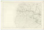
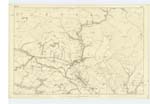
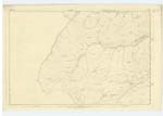
OS1/10/44/172


| List of names as written | Various modes of spelling | Authorities for spelling | Situation | Description remarks |
|---|---|---|---|---|
| KELLO WATER | Kello Water | John Dryfe James Pearson Johnston's County Map. History of Sanquhar, |
005; 006; 012 | A considerable stream having its source on Black Larg Hill - on the Boundary between the Counties of Ayr and Dumfries, and falling into the Nith a short distance to the east of Old Kello Side. It flows through a very bleak - moorland district and its bed generally - but more par- -ticularly from the Sheep-bridge at Drumb[uie] Plantation to Old Kello Side, is of an exceedingly rugged character, being cove[?red] in many places with large blocks of rock - apparently of the transition cl[?ass] The Kello from the Nith to the County Boundary (Ayr & Dumfries) forms the boundary between the Parishes of Sanquhar & Kirkconnel |
Continued entries/extra info
[Page:] 172Parish of Sanquhar. -- Sheet 5.16. Trace No [Number] 1, & 2
[KELLO WATER - Situation:]
On Wn. [Western] Parish
Boundary. -
[List of Names column has an entry for March Burn, re-directing to another page:]
March Burn -- March Burn -- See Page 266 for Authorities &c. [et cetera]
[Page is signed:]
C. A. [Civilian Assistant] Thomas Matheson
Transcriber's notes
KELLO WATER - some text in the Descriptive Remarks column is obscured in the binding.Transcribers who have contributed to this page.
George Howat
Location information for this page.