OS1/10/44/171


| List of names as written | Various modes of spelling | Authorities for spelling | Situation | Description remarks |
|---|---|---|---|---|
| DRUMBUIE PLANTATION | Drumbuie Plantation | John Dryfe James Pearson, William Armstrong, |
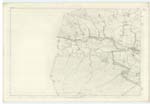
005 | [Situation] On En. [Eastern] Bank of Kello Water, 3 miles East of the Burgh of Sanquhar, A large fir plantation of 13 or 14 years growth on the farm of Drumbuie, the Property of His Grace The Duke of Buccleuch. Drumbuie Plantation is but a small portion of a very Extensive and continuous belt which stretches from east to west commencing on the Barr Farm, passing over Drumbuie and Crossing the Kello Water into Kirkconnel parish through which it is continued for apparently a Considerable distance in a northwesterly direction. This portion of the Belt takes its name from Drumbuie the farm upon which it is situated, |
| THWARTER BURN | Thurter Burn. Thwarter Burn Thwarter Burn |
John Dryfe. James Pearson. William Armstrong, Johnston's County Map Crawfords County Map |
005; 006; 012; 013 | [Situation] From S.W. [South West] side of Herd Hill N. [North] to Kello Water A small stream rising on the high ground forming the Southern limit of Drumbuie farm and flowing in a northerly direction until it falls into Kello Water, a little below the sheep-bridge at Drumbuie Plantation. The orthography of this name is gathered from the way in which it is pronounced - The Name is evidently derived from the rugged character of the sides or bed of this Stream. The Name may be written either Thorter or Thwarter, |
Continued entries/extra info
[Page] 171,Parish of Sanquhar -- Sheet 5.16. Trace No. [Number] 1
[DRUMBUIE PLANTATION - Situation:]
On En. [Eastern] Bank
of Kello Water, 3
miles East of the
Burgh of Sanquhar,
[THWARTER BURN - Situation:]
From S.W. [South West] side
of Herd Hill
N. [North] to Kello Water
[Page signed]
Thomas Matheson C A. [Civilian Assistant]
Transcribers who have contributed to this page.
Chr1smac -Moderator, George Howat
Location information for this page.