OS1/35/67/13


| List of names as written | Various modes of spelling | Authorities for spelling | Situation | Description remarks |
|---|---|---|---|---|
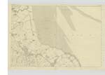
| RING HILL | Ring Hill Ring Hill Ringhill |
Mr. Robert McClelland Mr. C. Christison Ainslies Map of Galloway. |
026 | [Situation] On the farm of 'Balfern' (N) [North] bounded on the west by 'Balfern' & on the East by 'Shell Hill'. I mile East by South of Kirkinner. A prominent hill on its Summit is the Site of an old camp in shape of a ring, hence the name 'Ring Hill'. |
| CAMP | Old Camp Old Camp Ancient Intrenchment. |
Mr. J. Broadfoot G. McHaffie, Esqr. Rl. Engrs. [Royal Engineers] Map 1819. |
026 | [Situation] On the Summit of 'Ring Hill', on the farm of 'Balfern' (North). The 'Site of an Old Camp' supposed to be formed by the 'Danes'. The moat is not traceable. |
| WIGTOWN BAY | Wigtown Bay Wigtown Bay Wigton Bay |
G. McHaffie, Esqr. Mr. J. Muir Ainslie's Map 1782. |
026 | [Situation] On the East side of the Plan, extending N & S [North & South] of this Name. A large & very extensive Bay on the west side are the 'Baldoon Sands'. |
Continued entries/extra info
[Page] 13 -- Plan 26 A -- Parish of KirkinnerForm 136
Page 32 - Ring Hill
32- Old Camp
33- Wigtown Bay
Ring - A circular fort. Dr. [Doctor] Jamieson's Scot. Dicty. [Scottish Dictionary]
[Note] Camp - In the Statistical Acct. [Account] 1841, page 15, mention is made
"The vestiges of two circular camps may be traced,
"but there is no tradition connected with them".
Transcribers who have contributed to this page.
Chr1smac -Moderator, Muriel Rousay
Location information for this page.
Linked mapsheets.