OS1/35/19/91


| List of names as written | Various modes of spelling | Authorities for spelling | Situation | Description remarks |
|---|---|---|---|---|
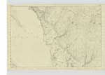
| ROCK MCGIBBON | Rock McGibbon | David Douglas Rood Farm Innermessan via Stranraer Peter Blane Low Innermessan (via) Stranraer Michael Gray Smith Innermessan via) Stranraer |
010 | This name applies to a Considerable Stone or Rock Within H. W. M. [High Water Mark] (Visible at half tide) Mention is Made of this is the Charter by which the Lands are held, A few Years back it was in Contemplation to Remove it but the Earl of Stairs Servants Stopp'd them although a hole had been bored for the Charge it is Situate N. W. [North West] of Innermessan Moat about 10 Chains. |
Continued entries/extra info
Plan 10 C -- List of Names collected by L Corpl. [Lance Corporal] William Rogers R S & [Royal Sappers & ] Miners -- 1st Examiner -- [Page] 91 -- Parish of Inch -- Trace 2 -- No. 136Object
Rock McGibbon - Rock & Land mark
[Signed]
13th. March 1847 by
William Rogers
L Corpl. [Lance Corporal] R S & M [Royal Sappers & Miners]
Transcribers who have contributed to this page.
Chr1smac -Moderator
Location information for this page.
Linked mapsheets.