OS1/32/7/14


| List of names as written | Various modes of spelling | Authorities for spelling | Situation | Description remarks |
|---|---|---|---|---|
| Waterhead | Waterhead Waterhead Waterhead Waterhead |
Estate Map Co. [County] Maps Valuation Roll J. Begg Factor |
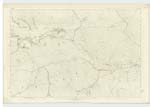
022 | A good Farm Steading in the north eastern extremity of the Parish on the Estate of Woodhead, the property of Lady Strangford. |
| Red Burn | Red Burn Red Burn Red Burn |
R. Kincaid D. Ferguson Shepherd D. Foyers Knowehead |
022 | A small stream which flows from the foot of "Lecket Hill" to the Burn forming the Parish Boundary. The stream is inconsiderate but the name is generally for miles around. |
| Toddle Knowe | Toddle Knowe Toddle Knowe Toddle Knowe Toddle Hill |
Neil McPherson Shepherd J. Davie Waterhead J Begg Factor Estate map |
022 | A small & crooked ridge near the Boundary Burn. It is well known in the locality as " Toddle Knowe" but not as "Toddle Hill" as given on Estate map. Another reason for the name being known is its proximity to the ancient Drove Road, from the north of Scotland to England, which passes close to it, but there is no track to be seen as the Road is seldom used now. The Gate for this Drove Road is near the Knowe (see description of "Drove Hill" Trace 14) |
Continued entries/extra info
[Page] 14Co. [County] Stirling -- Campsie Parish
Transcribers who have contributed to this page.
Alison James- Moderator, Rmgt
Location information for this page.
Linked mapsheets.