OS1/30/14/29


| List of names as written | Various modes of spelling | Authorities for spelling | Situation | Description remarks |
|---|---|---|---|---|
| Brown Knowe | Brown Knowe Brown Knowe Brown Knowe |
John Brockie David Brunton Yarrow Feus John Laidlaw Yarrowford |
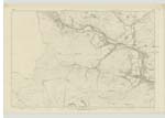
007 | This name is applied to the highest part of a hill, that extends about a mile and a half in an easterly direction from the Minchmoor road to the head of Penmanscore; on the top of the hill human bones have frequently been dug up. |
| Lucken Head | Lucken Head Lucken Head Lucken Head |
John Brockie David Brunton John Laidlaw |
007 | Part of a hill at the head of Gauntly Burn and east of the Brown Knowe. |
| Minchmoor Bog | Minchmoor Bog Minchmoor Bog Minchmoor Bog |
John Brockie John Laidlaw David Brunton |
007 | A mossy piece of ground, about a quarter of a mile south of the Nowte Market. |
| Wallace's Trench | Wallace's Trench Wallace's Trench Wallace's Trench |
John Brockie John Laidlaw David Brunton |
A trench near the top of the Brown Knowe and extending in a southerly direction & the Minchmoor road; there is a bank on the west side of the upper part of the trench. |
Continued entries/extra info
[Page] 29Parish of Yarrow
Sheet 7 Trace 4
Described by Sapper Montgomery RE [Royal Engineers]
Transcribers who have contributed to this page.
Skinnb1- Moderator, Soutar99
Location information for this page.
Linked mapsheets.