OS1/29/16/1


| List of names as written | Various modes of spelling | Authorities for spelling | Situation | Description remarks |
|---|---|---|---|---|
| HOBKIRK [parish] | Hobkirk Hobkirk Hobkirk |
Blackwood's Map of Roxburgh. Johnston's Map of Roxburgh Valuation Rolls for 1811. |
026; 032; 033; 039 | [Situation] In the S.En. [South Eastern] district of Roxburghshire. The name of this Parish is written in ancient documents Hopkirk an abbreviation probably of Hopekirk or the Kirk of the Hope. |
Continued entries/extra info
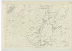
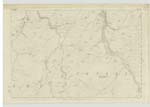
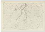
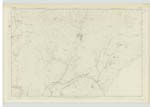
[Page] 1Parish of Hobkirk
County of Roxburgh.
The Parish of Hobkirk is bounded on the North by those of Cavers
Bedrule and Jedburgh, on the East by Southdean, on the South by Castleton and on the West by Cavers
From North to South it measures about 9 miles in length and from West to East about 3 miles in breadth
and has an area of about 16.242 Impl. [Imperial] Acres. There is no detached part of another Ph. [Parish] situated within its boundaries, nor is there a detached portion of this Ph. [Parish] within the boundaries of another. The principal Summits are at the Southern extremity
of the Parish where they have an elevation of about 1600 feet.
Merely the declination or base of this hill is situate within Hobkirk, the summit having been defined within common Ph [Parish] of Cavers where name was accordingly written.
Rubers Law a dark rugged and heath-covered
height at the northern extremity attains an elevation of 1420 feet - also Bonchester Hill in the N.En [North Eastern] district
reaches a height of about 1260 feet. The greater part of the arable lands lies principally along the valley
of the Rule the chief stream of the district, and on each side of which the ground rises with a considerable
acclivity to the eastern and western borders of the Parish. Rule Water the principal stream of
the district traces for the most part the Eastern boundary of the Nn. [Northern] division of Parish - receiving
during its whole course many minor streams from the interior. A line of Turnpike Road between
Hawick and Carlisle runs across the Nn. [Northern] division. No minerals are wrought - limestone is abundant and some
symptoms of coal formation have been met with. There are no villages, Hobkirk and Bonchester Bridge
being merely hamlets consisting of a few scattered houses. The Parish Church situate in the N.Wn. [North Western] district - erected
viz
Transcribers who have contributed to this page.
Skinnb1- Moderator, ElaineF
Location information for this page.