OS1/25/27/3


| List of names as written | Various modes of spelling | Authorities for spelling | Situation | Description remarks |
|---|---|---|---|---|
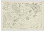
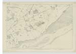
| ERROL [parish] | Errol Ph [Parish] Errol Ph [Parish] Errol Ph [Parish] Errol Ph [Parish] Errol Ph [Parish] Errol Ph [Parish] Errol Ph [Parish] |
New Stat. Acct. [Statistical Account] Sheriff's List of meresmen Fullarton's Gazetteer Oliver and Boyds Almk [Almanack] Old Stat. Acct. [Statistical Account] Johnston's Co [County] map Valn [Valuation] Roll of Co [County] 1857-8 |
087 ; 099 | [Situation] In the eastern side of Perthshire -- A parish on the northern shore of the Tay in the Carse of Gowrie Perthshire Its average length is about 5½ miles, its average breadth about 3 miles and its Superficial extent as computed from the Ordnance plans is 11723.070 imperial acres. It is bounded on the north by the parishes of Kinnard and Inchture, on the South by the Firth of Tay, on the west by the parishes of Kilspindie and St. Madoes and on the east by the parish of Inchture. Forming an integral part of the Carse of Gowrie its surface is generally flat. In the west however there are several ridges of slight elevation which extend in a direction nearly parallel with the Tay and give a pleasing diversity to the landscape. All the land in the parish is arable. The soil is principally composed of alluvial clay The parish of Errol is in the presbytery of Perth and Synod of Perth and Stirling. Patron - Allen Esqr of Errol. There are no detached portions of Errol parish nor are there any detached portions of any other parish within that of Errol. |
Continued entries/extra info
[page] 3 -- Parish of ErrolTranscribers who have contributed to this page.
Moira L- Moderator, Claire
Location information for this page.