OS1/25/15/12


| List of names as written | Various modes of spelling | Authorities for spelling | Situation | Description remarks |
|---|---|---|---|---|
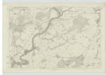
| Site of ROMAN ROAD [Gallowhill; Woodhead] | Roman Road Roman Road Roman Road Roman Road Roman Road |
Peter Stewart, Woodhead Mrs. Boyd Gallowhill Mr. James Ramsay, Burrelton John Pirnie Burrelton John Scott, Burnside |
074 | An old road, which the authorities here quoted, say, that it is traditionally handed down as having been made by the Romans, and had extended from Stirling to Coupar Angus. John Pirnie says that when he was a boy at school in Newbigging, that the portion of it passing Gallowhill was quite entire, and went under the name of the Long Causeway, from the fact of it being paved with stones. The greater portion of it through this parish is long since obliterated and cannot now be identified, except the site of those 2 portions. 1st. at Woodhead in plan "74.10 " and secondly at Gallowhill in Plan "74.7." These were pointed out by Peter Stewart, And Mrs Boyd of Gallowhill. In reference to the portion on this plan passing Wellsies, there is nothing to appearance remarkable about it, farther than any other worn out, or disused road. And as to its continuation from the "Village Acres", Mr. Ramsay says that it had passed close by the Free Church in Woodside, and crossed the Turnpike road somewhere about 50 yards south West of the farm house of Crossroads in plan 75-1. thence to the Roman Camp at Coupar Angus. Its whole Course through the parish seems to have kept the summit of a gentle ridge where a good view of the adjacent country can can be obtained. |
Continued entries/extra info
[Page] 12[Initials beneath Object Name:]
JB
Lt Col. [Lieutenant Colonel]
Written to the ascertained track at Gallowhill & Woodhead.
The Track itself shown at Wellsies on 74/4. [Initialled] JB
"The Roman Road, & Richard's Itinerary, took different directions; and we may infer,
from this unnoticed circumstance, that they belonged to different ages, or at least
were composed, with dissimlar views. Having crossed the Tay, by means of the wooden
bridge, the Roman road went up the east side of the river, and passed through the
centre of the camp at Grassy-walls. From this position, the remains of the road are distinct,
for a mile, up to Gellyhead (in Scone parish), on the west of which it passed; and
went on, by Innerbuist, to Nether Collin, where it again becomes apparent; and
continues distinct to the eye, for 2½ miles; passing, in its obvious course, to
Drichmuir and Byres (in St. Martins parish). The Road now went forward, in a
North east direction, passing between Blairhead and Gillwell, to Woodhead;
and thence pushing on, by Newbigging, and Gallowhill, on the right, it
decends Leyston-Moor; and passing that Village, it proceeds forward to the
Roman camp at Coupar Angus."
Chalmers Caledonia, page 148
The land immediately north of the Roman Road at Wellsies farm house
wont to be Called Layston Muir, informed so by Mr. Macintosh
farmer, of Wellsies, but no one knows of a Village of the name.
Transcribers who have contributed to this page.
Alison James- Moderator, GMB
Location information for this page.
Linked mapsheets.