OS1/24/2/3


| List of names as written | Various modes of spelling | Authorities for spelling | Situation | Description remarks |
|---|---|---|---|---|
| BROUGHTON-GLENHOLM AND KILBUCHO | Broughton Broughton Broughton Broughton Broughton Glenholm Kilbucho Broughton Glenholm Kilbucho Broughton etc |
Sheriff's list of Parishes Johnston's Map of Peebles Chalmer's Caledonia Old Stat Acct. [Statistical Account] V [Volume] 7 Page 156 New Stat [Statistical] Account Fullerton's Gazetteer Oliver and Boyd's [Almanack] |
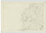
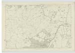
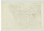
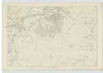
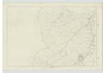
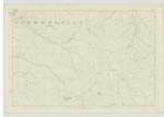
011 ; 012 ; 015 ; 016 ; 019 ; 020 | [Situation] In the Western portion of the County of Peebles A Parish in the County of Peebles which Comprehends the Old Parishes of Broughton, Glenholm and the Southern or larger division of Kilbucho, but strictly identified on their ecclesiastical Connection and Statistics. This United Parish is bounded on the West and North West by Cutler [Culter] and Skirling, on the North by Kirkurd, on the East and North East by Stobo, and on the South and South East by Drummelzier. It is 9½ Miles long and about 3½ Miles broad. The superficial Area is about 20,390 acres of which upwards of ¼ is under Cultivation, the Remainder is principally under pasture for sheep and black Cattle. The surface of the ground is beautifully irregular and well watered |
| GLENHOLM | Glenholm Glenholm Glenholm Glenholm Broughton, Glenhom & Kilbucho Broughton, Glenholm & Kilbucho Broughton etc |
Sheriffs list of Parishes Chalmer's Gazetteer Johnston's County Map Old Stat Acct. [Statistical Account] Volume 4 page New Stat Acct. [Statistical Account] Fullarton's Gazetteer Oliver & Boyd's almanack |
011; 012; 015; 016; 019; 020 | [Situation] in the Western portion of the County of Peebles A Parish in the County of Peebles which Comprehends the Old Parishes of Broughton, Glenholm and the Southern or larger division of Kilbucho, but strictly identified on their ecclesiastical Connection and Statistics. This United Parish is bounded on the West and North West by Cutler [Culter] and Skirling, on the North by Kirkurd, on the East and North East by Stobo, and on the South and South East by Drummelzier. It is 9½ Miles long and about 3½ Miles broad. The superficial Area is about 20,390 acres of which upwards of ¼ is under Cultivation, the Remainder is principally under pasture for sheep and black Cattle. The surface of the ground is beautifully irregular and well watered |
Continued entries/extra info
[page] 3Transcribers who have contributed to this page.
Moira L- Moderator, P Wills
Location information for this page.
Linked mapsheets.