OS1/17/27/103


| List of names as written | Various modes of spelling | Authorities for spelling | Situation | Description remarks |
|---|---|---|---|---|
| BEINN NA H-EAGLAISE | Beinn na h' Eaglaise | Rev. [Reverend] J. McRae, E.C. [Established Church] Glenelg. Mr A. Barclay, Schoolmaster, Arnisdale Mr A. McCaskell, gamekeeper Arnisdale |
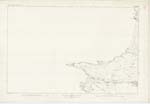
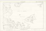
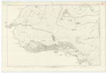
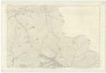
062 | An eminence of considerable height, situate between Beinn Buidhe and Bealach Arnasdail, and about a mile N.W. [North West] of Camus Bàn Sig. [Signification] "Mountain of the Church." |
| BEINN BHUIDHE | Beinn Bhuidhe | Rev. [Reverend] J. McRae, E.C. [Established Church] Glenelg. Mr A. Barclay, Schoolmaster, Arnisdale Mr A. McCaskell, gamekeeper Arnisdale |
062 ; 063 | A considerable eminence, situate about a mile N.W. [North West] of Camus Bàn, and forming the S.E. [South East] extremity of a range of Hills N. [North] of Loch Hourn. Sig.- [Signification] "Yellow Mountain." |
| ALLT A' BHILE | Allt a Bhile | Rev. [Reverend] J. McRae, E.C. [Established Church] Glenelg. Mr A. Barclay, Schoolmaster, Arnisdale Mr A. McCaskell, gamekeeper Arnisdale |
062 | A stream, rising between Beinn na h' Eaglaise and Beinn Bhuide, and flowing into Camus Bàn Sig.- [Signification] "Burn of the Rim or Edge." |
Continued entries/extra info
[Page] 103Sheet 62
Parish of Glenelg. Co. [County] Inverness.
[Signed] Charles Cooke. Sapper, R.E. [Royal Engineers]
Transcribers who have contributed to this page.
Jm Bell
Location information for this page.
Linked mapsheets.