OS1/14/10/70


| List of names as written | Various modes of spelling | Authorities for spelling | Situation | Description remarks |
|---|---|---|---|---|
| GAA SAND | Gaa Sand Gaa Sand Gaa Sand Gaa Sand |
Chart of Frith of Tay, by Robert Stevenson C.E. [Civil Engineer] 1816 Chart of Frith of Tay, by Commander Slater 1813 Mr. Jack Harbour Master Dundee James Martin Lighthouse Keeper |
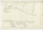
055 | [Situation] At the SE [South East] side of Buddon Ness This name applies to the part of Barry Sands situated at the S.E. [South East] corner of the parish. The name is well known, and marked on the several charts of the Frith of Tay |
| BUDDON NESS | Buddon Ness Buddon Ness Buddon Ness Buddon Ness |
Chart of Frith of Tay by Robert Stevenson C.E. [Civil Engineer] 1816 Chart of Frith of Tay, by Commander Slater 1835 Mr. Jack Harbour Master Dundee James Martin Lighthouse Keeper |
055 | [Situation] Consisting of the south point of Barry parish A headland or promonatory forming the N.E. [North East] Corner of Barry Parish. The coast northward from this headland is washed by the German ocean, and westward by the Frith of Tay. |
Continued entries/extra info
[Page] 70Barry parish -- Sheet 55.8 trace 4.
Transcribers who have contributed to this page.
Alison James- Moderator
Location information for this page.
Linked mapsheets.