OS1/10/53/42


| List of names as written | Various modes of spelling | Authorities for spelling | Situation | Description remarks |
|---|---|---|---|---|
| KIRK GILL HILL | Kirk Gill Hill Kirk Gll Hill |
John Armstrong Shepherd Kirkton Hill James Glendinning Shepherd Rigg |
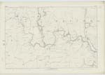
035; 036 | [Situation] 1/2 Mile S.W. [South West] of Great Hill. An eminence of a ridge like Shape on the farm of Georgefield Situated West of Kirk Burn. The surface of which is Rough and Heathy Pasture. |
| BOSSTREE HEIGHTS | Bosstree Heights Bosstree Heights |
John Armstrong Shepherd Kirkton Hill James Glendinning Shepherd Rigg | 036 | [Situation] About 3/4 of a Mile S.W. [South West] of Great Hill. A ridge situated South of Great Hill on the farm of Georgefield The surface of which is Heathy Pasture |
| KIRK BURN | Kirk Burn Kirk Burn |
James Armstrong Farmer Effgill John Armstrong Shepherd |
036 | [Situation] About 1/2 Mile S.W. [South West] of Kirk Gill Hill. A large stream which rises between Great Hill and Kirkgil Hill and flows South until it joins the Esk a short distance east of Westerkirk Kirk. |
| RIG BURN | Rig Burn | See Name Sheet for Plan 36/6 Page 46. |
Continued entries/extra info
[Page] 42Parish of Westerkirk -- Sheet 36 No 5 Trace 5
Transcribers who have contributed to this page.
DANIALSAN, Larry mag
Location information for this page.
Linked mapsheets.