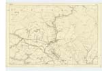
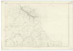
OS1/10/44/228


| List of names as written | Various modes of spelling | Authorities for spelling | Situation | Description remarks |
|---|---|---|---|---|
| AUCHENGRUITH MOOR | Auchengruith Muir Auchengruith Muir Auchengruich Muir Auchengrouth Muir Auchengruith - - - Auchengruith |
James Dalziel James Stewart Old Estate Map Revd. Dr. [Reverend Doctor] Simpson Johnston's County Map. - William Maxwell Esquire Chamberlain to the Duke of Buccheuch. |
006 | [Struck out text in Hand 1] [Hand 2] An enclosed district of reclaimed Mossy soil, partly, arable R.P. [Rough Pasture] & P.P., [Permanent Pasture] It is a portion of the farm of Auchengruith,. |
| COAL BURN | Coal Burn | James Dalziel James Stewart Old Estate Map |
006 | A small Burn running in a Southe [South] East direction, and falling in to Glendyne Burn betwixt Auchentaggert and Auchengruith Muirs. and near to a great curve of a Parish Road |
| GLENDYNE BURN | Glendyne Burn | Old Estate Map James Dalziel History of Sanquhar |
006; 007 | A fine large Burn having its source near Wanlock Head, After leaving the Hills it runs between two large tracts of Table land, falls in to the Menneck Water about 1 mile from Menneck Bridge |
Continued entries/extra info
[Page:] 228Parish of Sanquhar -- Plan 6.16 Trace No. [Number] 2.
[AUCHENGRUITH MOOR - Situation:]
Almost in the centre
of Sanquhar Parish-
[COAL BURN - Situation:]
10 Chains S,E, [South East] of
Brandleys Cottage
S,E, [South East] to Glendyne
Burn. -
[GLENDYNE BURN - Situation]
From S, En. [South Eastern] slope
of Stood Hill, SW. [South West]
to Menock Water.
[Page is signed:]
Charles J Fearnside
Pte. [Private] R.S. & M's. [Royal Sappers and Miners]
Transcriber's notes
AUCHENGRUITH MOOR- The abbreviations R.P. and P.P. in Descriptive Remarks have been transcribed as Rough Pasture and Permanent Pasture, respectively. The former agrees with transcribers in other pages, the "permanent" is suggested by reference to e.g. http://www.ukagriculture.com/crops/grassland_uk.cfm
Transcribers who have contributed to this page.
George Howat
Location information for this page.