OS1/10/38/173


| List of names as written | Various modes of spelling | Authorities for spelling | Situation | Description remarks |
|---|---|---|---|---|
| BLACKHOPE BURN | Blackhope Burn Blackhope Burn |
James Johnstone, Copplegill David Johnstone, Copplegill David Bryden, Bodesbeck Walter Johnstone, Archbank |
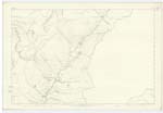
010 | [Situation] From the junction of cold Grain and Whirly Gill Burn S.E. [South East] to Moffat Water. Is formed by the confluence of the Cold Grain and Whirlie Gill, and runs almost in a direct line for about 3 miles, to the Moffat Water, at Bodesbeck. The sides of the Hope or Hollow through which this stream flows, is said to be the steepest, and most rugged in the south of Scotland. |
| BLACK HOPE | Black Hope Black Hope Black Hope |
Walter Johnstone, Archbank Micael Johnstone, Archbank John Thompson, Moffat |
010 | [Situation] East of Black Craig. A dark, rugged glen situated near Copplegill. No glen in the south of Scotland can be compared to this, for the steepness of its hills, and the narrowness of the glen. It derives its name from its dark appearance. |
Continued entries/extra info
[Page] 173Parish of Moffat Sheet 10.9 Trace 3
[signed] John Jane Sapper R.E. [Royal Engineers]
Transcribers who have contributed to this page.
norma
Location information for this page.
Linked mapsheets.