OS1/10/22/1


| List of names as written | Various modes of spelling | Authorities for spelling | Situation | Description remarks |
|---|---|---|---|---|
| GRETNA | Gretna | Walkers' Map of Scotland Crawford's Map of Dumfriesshire Johnston's Map of Dumfriesshire |
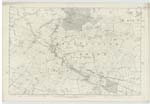
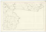
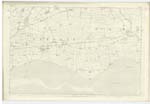
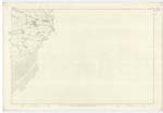
058; 059; 063; 064 | [Situation] At the S.En. [South Eastern] extremity of the County of Dumfries. - The name of this Parish was originally written Gretenhow. It is derived from Anglo-Saxon Gretan large and Hol - pronounced How - a hollow, which is descriptive of the village of Gretna situate as it is in a hollow upon the East bank of Kirtle Water. The Parish of Gretna is bounded on the North by Kirkpatrick Fleming and Half Morton on the East by Kirkandrews in Cumberlandshire, on the South by the Solway Firth and on the West by Dornock. There is no part of it detached nor is there within its boundaries a detached portion of any other Parish. Resembling in figure a paralm. [parallelogram] it stretches from East to west a distance of about 6½ miles and has an average breadth of nearly 3¼ miles. Its area has now been computed at 7926 acres of which 7,466 are arable, 400 pasture & 60 wood. There is also a Sandy Sea beach or foreshore measuring between 2,000 & 2,500 acres. The whole surface is flat, the soil for the most part being of a rich loamy nature interspersed with patches of moss. There are two prominent headlands on the Coast called RedKirk and Tordoff Points, the latter being rather of a bold character. - The district is well watered throughout with excellent springs which rise through Sandstone rock or beds of Sand of a reddish colour. - Sark a small river separates Gretna from Kirkandrews in England, Kirtle Water celebrated for the romantic scenery on its banks nearly bisects the Parish running S.E. [South East] to the Solway, and Black Sark from near the North-west [Continued on page 2] |
Continued entries/extra info
[page] 1Parish of Gretna -- County of Dumfries
Transcribers who have contributed to this page.
Moira L- Moderator, PeterRSL
Location information for this page.