OS1/10/19/5


| List of names as written | Various modes of spelling | Authorities for spelling | Situation | Description remarks |
|---|---|---|---|---|
| THE KIPPS | The Kipps The Kipps |
Archibald Glendinning, Glendearg. James Glendinning, Over Cassock |
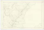
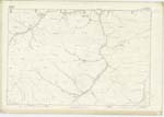
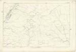
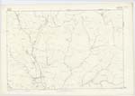
010 | [Situation] Northern portion of Eskdalemuir A range of elevated Knowes to the east of Ettrick Pen, along which the boundary separating the Counties of Dumfries and Selkirk, runs. The southern part of them are situated on the farm of Over Cassock, and consist of moss and rough pasture. On the highest of the above knowes there is a Trigl. [Trigonometrical] station called Kipps Hill |
| MUCKLE CAULDRON BURN | Muckle Cauldron Burn Muckle Cauldron Burn |
James Glendinning, Over Cassock. Archibald Glendinning, Glendearg |
010; 011; 017; 018 | [Situation] Flows 1/2 Mile South of the Kipps A considerable stream having its source on the east side of Ettrick Pen - flows south of the Kipps and north of Dob's Craig - and after receiving the Little Cauldron Burn, assumes the name of Strongcleugh Burn which, finally falls into Glendearg Burn. |
| BUZZARD LINN | Buzzard Linn Buzzard Linn |
James Glendinning Farmer Over Cassock Archibald Glendinning Farmer Glendearg |
010 | [Situation] on Little Cauldron Burn South of the Kipps A small cataract on the Little Cauldron Burn, and near its source; on the farm of Over Cassock. |
Continued entries/extra info
[Page] 5Parish of Eskdalemuir
Sheet 10. No. 16 Trace 2
Transcribers who have contributed to this page.
CorrieBuidhe- Moderator, VickiColeman
Location information for this page.