OS1/10/6/246


| List of names as written | Various modes of spelling | Authorities for spelling | Situation | Description remarks |
|---|---|---|---|---|
| GAWIN MOOR | Gawin Moor | Robert Boreland, Auchencairn James Blackwood, Pothouse Samuel McAdam, Clauchrie |
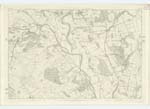
031; 032 | [Situation] Forming the S.En [South Eastern] Parish District A large district of Moor land lying to the east of Auchencairn. Embraces the whole of the moor land within the farm of Auchencairn and the conjoined farm of Pothouse |
| AUCHENCAIRN HEIGHT | Auchencairn Height | Robert Boreland James Blackwood Samuel McAdam |
032 | [Situation] On Gawin Moor 3/4 mile E, [East] of Auchencairn A small ridgelike hill situated in Gawin Moor, and lying immediately to the east of Auchencairn Wood |
| Site of ROYACH CAIRN | Royach Cairn (Site of) (Tumulus Royach Cairn (Site of) (Tumulus |
Robert Boreland James Blackwood Johnston's County Map Estate Map |
032 | [Situation] On Auchencairn Height Several large tumuli consisting of small stones are to be found on the heights within Gawin Moor One of these called Royach Cairn formerly existed on Auchencairn Height, but the stones were removed some time ago to build fences |
Continued entries/extra info
[page] 246Parish of Closeburn -- Plan 32-13 -- Trace 2
[signed] W. Paterson c/a [Civilian Assistant]
Transcribers who have contributed to this page.
Moira L- Moderator
Location information for this page.