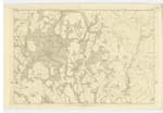
OS1/10/6/150


| List of names as written | Various modes of spelling | Authorities for spelling | Situation | Description remarks |
|---|---|---|---|---|
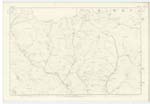
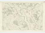
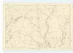
| BLAWPLAIN | Blawplain Blaplain |
James Brown, Holm William Brown, Holm Valuation Rolls Johnstones Co [County] Map |
031 | [Situation] 1/2 mile S,W, [South West] from KirKbog, A dwelling house, with garden, barns etc attached. The farm of land formerly attached is now included in that of the Holm |
| RIVER NITH | River Nith | James Brown, William Brown Edward Elton, Kirkbog |
031; 040 | [Situation] From Morton Parish S,S,E, [South South East] to Nn [Northern] Parish Boundary A large river flowing through the Parish [in] a Southern direction, but occasionally forms the boundary |
| CAMPLE WATER | Cample Water | James Brown William Brown Edward Elton |
022; 023; 031; 032 | [Situation] Tracing Wn [Western] Parish Boundary - S,S,W, [South South West] to River Nith, A large Stream rising in the parish of [Morton] flows in a western direction along the boundary of the parish & falls into the Nith. - |
Continued entries/extra info
[page] 150Parish of Closeburn -- Plan 31-6 -- Trace 2
[signed W. Paterson c/a [Civilian Assistant]
Transcribers who have contributed to this page.
Chr1smac -Moderator, Moira L- Moderator
Location information for this page.
Linked mapsheets.