
Freswick Castle


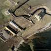
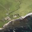
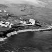
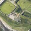
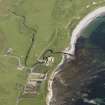
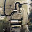
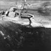
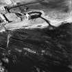
Oblique aerial view of Freswick castle, bridge, farmsteading and the remains of the mausoleum, dovecot and anti-tank blocks, taken from the E.
View in Canmore
View in Canmore

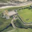
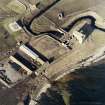
Oblique aerial view of Freswick Castle and bridge, looking ESE.
View in Canmore
View in Canmore

Oblique aerial view of the castle, bridge, farmsteading and the remains of the mausoleum, dovecot and anti-tank blocks, taken from the NE.
View in Canmore
View in Canmore

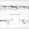
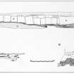
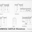
Elevation/sections - north, west and east walls. Glasgow Archaeological Journal, vol. 11
(1984), fig.5.
View in Canmore
View in Canmore

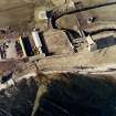
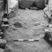
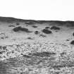
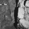
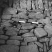
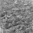
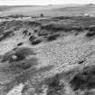
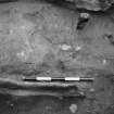
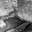
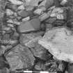
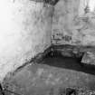
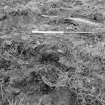
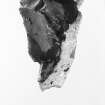
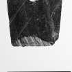
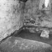
Excavation photograph. View of trench. October 1979.
View in Canmore
View in Canmore

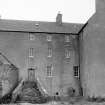
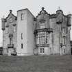
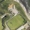
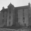
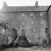
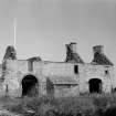
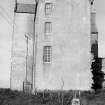
Survey photograph. View of castle.
View in Canmore
View in Canmore

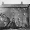
Survey photograph. View of castle from courtyard.
View in Canmore
View in Canmore

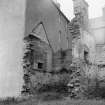
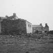
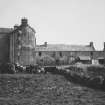
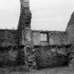
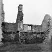
Survey photograph. View of derelict range.
View in Canmore
View in Canmore

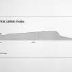
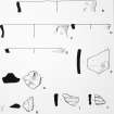
Fig. 14. Pottery small finds. Profiles.
View in Canmore
View in Canmore


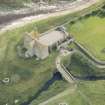
View of mausoleum with castle in background
View in Canmore
View in Canmore

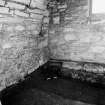
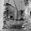
Room 2. Detail of NW corner, oblique from SE.
View in Canmore
View in Canmore

Oblique aerial view centred on Freswick Castle, taken from the ESE.
View in Canmore
View in Canmore

Oblique aerial view of Freswick Castle and bridge, looking NNE.
View in Canmore
View in Canmore

Excavation photograph. Detail of trench. October 1979.
View in Canmore
View in Canmore

Survey photograph. View of castle and bridge.
View in Canmore
View in Canmore

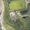
Aerial view showing the castle, bridge, mausoleum and dovecot at Freswick.
View in Canmore
View in Canmore

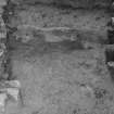
Excavation photograph. Cobbled surface. October 1979.
View in Canmore
View in Canmore


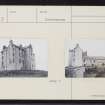
View of Castle elevation
View in Canmore
View in Canmore

Excavation photograph. View of trench. October 1979.
View in Canmore
View in Canmore

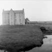
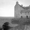
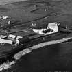
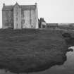
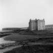
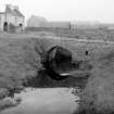
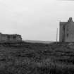
View of bridge and castle from south west
View in Canmore
View in Canmore

Oblique aerial view of Freswick Castle and bridge, looking SW.
View in Canmore
View in Canmore

Oblique aerial view of the castle, bridge, farmsteading and the remains of the mausoleum, dovecot and anti-tank blocks, taken from the SE.
View in Canmore
View in Canmore

Aerial photograph of Freswick Castle, dovecot and mausoleum.
View in Canmore
View in Canmore

Survey photograph. View of ruined wing.
View in Canmore
View in Canmore

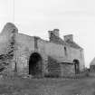
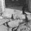
View of courtyard and entrance stairway.
View in Canmore
View in Canmore


Freswick Castle, ND36NE 3, Ordnance Survey index card, page number 2, Recto
View in Canmore
View in Canmore

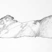
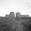
General view
View in Canmore
View in Canmore

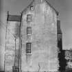
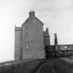
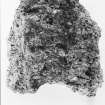
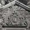
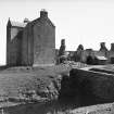
View of gable of castle.
View in Canmore
View in Canmore

View of castle and bridge.
View in Canmore
View in Canmore

Oblique aerial view of Freswick Castle and bridge, looking SSE.
View in Canmore
View in Canmore

Excavation photograph. Detail of trench. October 1979.
View in Canmore
View in Canmore

Excavation photograph. View of trench. October 1979.
View in Canmore
View in Canmore

Survey photograph. View of castle.
View in Canmore
View in Canmore

Survey photograph. View of derelict range.
View in Canmore
View in Canmore

Fig. 6. Trench sections. The original ink drawings for this illustration came from DC 467, DC 490 & DC 491.
View in Canmore
View in Canmore

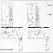
Fig. 7. Trench plans. The original ink drawings for this illustration came from DC 496, DC 495, DC 493, DC 487 & DC 486.
View in Canmore
View in Canmore

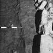
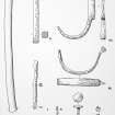
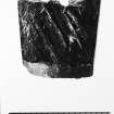
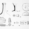
Fig. 12. Shoe leather.
View in Canmore
View in Canmore

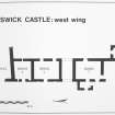
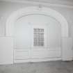
FC W wing.
View in Canmore
View in Canmore


Freswick Castle, ND36NE 3, Ordnance Survey index card, page number 1, Recto
View in Canmore
View in Canmore

Freswick Castle, ND36NE 3, Ordnance Survey index card, Recto
View in Canmore
View in Canmore

View of courtyard and entrance stairway.
View in Canmore
View in Canmore

Excavation photograph. View of trench. October 1979.
View in Canmore
View in Canmore

Oblique aerial view centred on Freswick Castle, taken from the SSE.
View in Canmore
View in Canmore

Oblique aerial view of Freswick Castle and bridge, looking E.
View in Canmore
View in Canmore

Excavation photograph. Room 2: detail of NE corner, oblique from SW.
View in Canmore
View in Canmore

Elevations. Glasgow Archaeological Journal, vol. 11 (1984), fig.3.
View in Canmore
View in Canmore

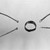
Recorded finds of metal. Glasgow Archaeological Journal, vol. 11 (1984), fig.10.
View in Canmore
View in Canmore

Excavation photograph. Detail of trench. October 1979.
View in Canmore
View in Canmore

Excavation photograph. View of trench. October 1979.
View in Canmore
View in Canmore

Survey photograph. View of ruined wing.
View in Canmore
View in Canmore

Survey photograph. View of castle.
View in Canmore
View in Canmore

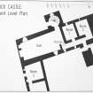
Freswick Castle: Basement Level Plan (2 negatives). Copy in library.
View in Canmore
View in Canmore

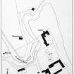
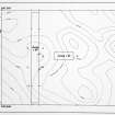
Fig. 2. Location of Garden trenches. Copy in library.
View in Canmore
View in Canmore

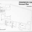
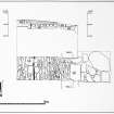
Fig. 4. Ground plan. Copy in library. Original illustration based on pencil drawing DC 498.
View in Canmore
View in Canmore


Freswick Castle, ND36NE 3, Ordnance Survey index card, page number 2, Verso
View in Canmore
View in Canmore

Oblique aerial view of the castle, bridge, farmsteading and the remains of the mausoleum, dovecot and anti-tank blocks, taken from the SE.
View in Canmore
View in Canmore

Oblique aerial view of the castle, bridge, farmsteading and the remains of the mausoleum, dovecot and anti-tank blocks, taken from the E.
View in Canmore
View in Canmore

Excavation photograph. View of trench. October 1979.
View in Canmore
View in Canmore

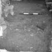
View of trench. October 1979.
View in Canmore
View in Canmore

Survey photograph. View of bridge.
View in Canmore
View in Canmore

Trench plans. The original ink drawings for this illustration came from DC 489, DC 492 & DC 497.
View in Canmore
View in Canmore

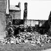
View of castle and bridge. Collapse of outbuilding.
View in Canmore
View in Canmore

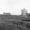
View of castle with mausoleum, and dovecot in foreground
View in Canmore
View in Canmore

Excavation photograph. Detail of trench. October 1979.
View in Canmore
View in Canmore

Oblique aerial view of the castle, bridge, farmsteading and the remains of the mausoleum, dovecot and anti-tank blocks, taken from the NE.
View in Canmore
View in Canmore

Excavation photograph. View of trench. October 1979.
View in Canmore
View in Canmore

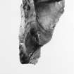
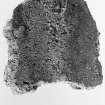
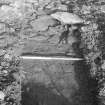
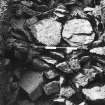
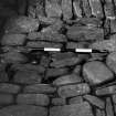
Detail of foundation. October 1979.
View in Canmore
View in Canmore

Survey photograph. View of ruined wing.
View in Canmore
View in Canmore

Survey photograph. View of castle and mausoleum..
View in Canmore
View in Canmore

Survey photograph. Castle and mausoleum.
View in Canmore
View in Canmore

View of ruined wing.
View in Canmore
View in Canmore

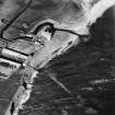
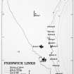
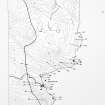
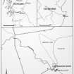
Canisbay (East) Map
View in Canmore
View in Canmore

View of derelict range. Detail of collapse.
View in Canmore
View in Canmore

Excavation photograph. Cobbled surface. October 1979.
View in Canmore
View in Canmore


Freswick Castle, ND36NE 3, Ordnance Survey index card, Recto
View in Canmore
View in Canmore

Oblique aerial view of the castle, bridge, farmsteading and the remains of the mausoleum, dovecot and anti-tank blocks, taken from the E.
View in Canmore
View in Canmore

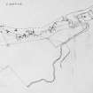
Location maps of Freswick Castle. Glasgow Archaeological Journal, vol. 11 (1984), fig.1.
View in Canmore
View in Canmore

Recorded finds of glass, bone, stone, clay and mortar. Glasgow Archaeological Journal,
vol. 11 (1984), fig.11.
View in Canmore
View in Canmore

Selected pottery sherds. Glasgow Archaeological Journal, vol. 11 (1984), fig.13.
View in Canmore
View in Canmore

Room 2. Detail of NW corner, oblique from SE.
View in Canmore
View in Canmore

Excavation photograph. Detail of trench. October 1979.
View in Canmore
View in Canmore

View of gable of castle.
View in Canmore
View in Canmore

You may copy, display, store and make derivative works for personal use or use solely within an educational institution by staff and students, under these conditions: the ScotlandsPlaces website is attributed, there is no commercial use or sale, and no public distribution (for example, by hand, email, or web). Full licence details.