
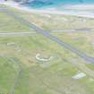
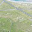
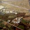
Benbecula Airport, Airfield


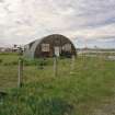
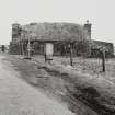
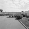
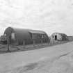
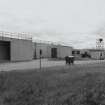
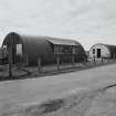
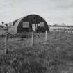
Detail of nissen huts on South East perimeter
View in Canmore
View in Canmore

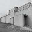
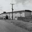
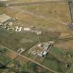
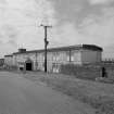
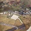
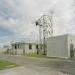
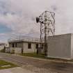
Detail of W side of station.
View in Canmore
View in Canmore

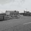
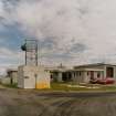
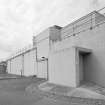
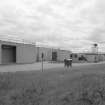
View of WW11 building to right of security gate from WSW.
View in Canmore
View in Canmore

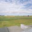
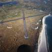
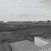
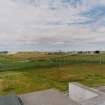
View over airfield from ESE from roof of station.
View in Canmore
View in Canmore

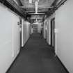
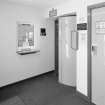
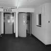
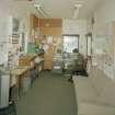
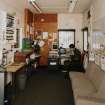
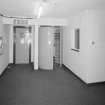
Interior.
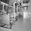
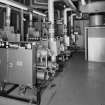
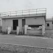
Detail of plant room.
View in Canmore
View in Canmore

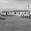
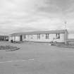
View of officers mess from NNW.
View in Canmore
View in Canmore

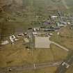
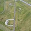
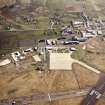
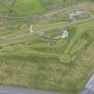
Oblique aerial view.
View in Canmore
View in Canmore

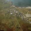
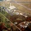
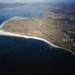
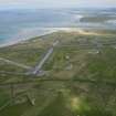
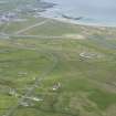
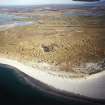
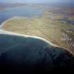
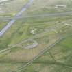
Oblique aerial view centred on the airfield with the township adjacent, taken from the SW.
View in Canmore
View in Canmore

View of W side of station from SW.
View in Canmore
View in Canmore

View of E side of station from NNE.
View in Canmore
View in Canmore

Interior.
Detail of plant room.
View in Canmore
View in Canmore

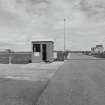
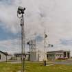
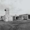
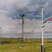
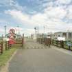
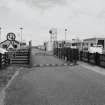
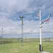
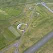
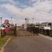
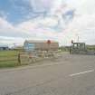
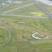
View of airfield security gate and control tower from S.
View in Canmore
View in Canmore

Oblique aerial view.
View in Canmore
View in Canmore

Oblique aerial view centred on the airfield with the township adjacent, taken from the N.
View in Canmore
View in Canmore

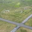
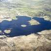
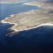
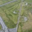
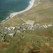
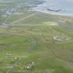
General oblique aerial view centred on the remains of the dun and the buildings looking towards the crofting township of Dunganachy and to Benbecula Aerodrome beyond, taken from the SE
View in Canmore
View in Canmore

General view.
View in Canmore
View in Canmore

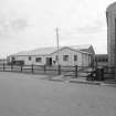
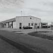
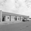
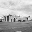
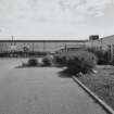
General view of station from SW.
View in Canmore
View in Canmore

Interior.
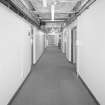
View of main access corridor from E.
View in Canmore
View in Canmore

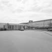
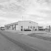
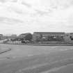
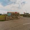
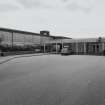
View of Benbecula civilian airport terminal from ESE.
View in Canmore
View in Canmore

View of airfield security gate and control tower from South
View in Canmore
View in Canmore

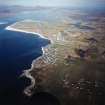
General oblique aerial view looking over Balvanich and Benbecula airport, towards Grimsey in the distance, taken from the W.
View in Canmore
View in Canmore

Oblique aerial view centred on Balivanich village with Benbecula airfield adjacent, taken from the SE.
View in Canmore
View in Canmore

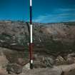
View of excavated section with scale.
View in Canmore
View in Canmore

Interior.
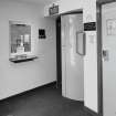
View of entrance hall and turnstile from SE (visitors side).
View in Canmore
View in Canmore

View of Benbecula civilian airport terminal from SW.
View in Canmore
View in Canmore

Oblique aerial view.
View in Canmore
View in Canmore

General oblique aerial view looking over Balvanich and Benbecula airport, towards Grimsey in the distance, taken from the W.
View in Canmore
View in Canmore

View of station from SSW.
View in Canmore
View in Canmore

Detail of W side of station.
View in Canmore
View in Canmore

View over airfield from ESE.
View in Canmore
View in Canmore

Interior.
View of entrance hall and turnstile from SE (visitors side).
View in Canmore
View in Canmore

View of officers mess from NE.
View in Canmore
View in Canmore

View of former WW11 guardroom on SW perimeter from SE.
View in Canmore
View in Canmore

Oblique aerial view centred on Balivanich village with Benbecula airfield adjacent, taken from the NNE.
View in Canmore
View in Canmore

Digital copy of oblique aerial view centred on the village with the airfield adjacent, taken from the SSE.
View in Canmore
View in Canmore

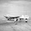
Alistair Maclaren boarding the plane at Benbecula, on the way back from excavations at Drimore.
View in Canmore
View in Canmore

View of security gate from SSW.
View in Canmore
View in Canmore

View of officers mess from W.
View in Canmore
View in Canmore

View of officers mess from NE.
View in Canmore
View in Canmore

Detail of WW11 building adjacent to 'Winfield Way' staff housing.
View in Canmore
View in Canmore

View of Benbecula civilian airport terminal from ESE.
View in Canmore
View in Canmore

Oblique aerial view.
View in Canmore
View in Canmore

Oblique aerial view centred on the village with the airfield adjacent, taken from the SSE.
View in Canmore
View in Canmore

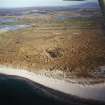
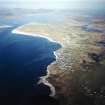
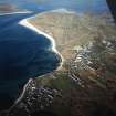
General oblique aerial view looking across the bay of Culla towards the crofting township of Aird with the township of Balvanich and Benbecula aerodrome beyond, taken from the WSW.
View in Canmore
View in Canmore

General oblique aerial view looking over Benbecula airport and Gramasdail towards The Little Minch beyond, taken from the NNW.
View in Canmore
View in Canmore

Oblique aerial view centred on the village with the airfield adjacent, taken from the S.
View in Canmore
View in Canmore

Oblique aerial view centred on the village with the airfield adjacent, taken from the NNE.
View in Canmore
View in Canmore

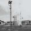
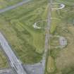
View of main entrance gate from SSW.
View in Canmore
View in Canmore

Interior.
View of entrance hall and turnstile from N (staff side).
View in Canmore
View in Canmore

Interior.
View of guardroom/security office from N.
View in Canmore
View in Canmore

Detail of WW11 building adjacent to 'Winfield Way' staff housing.
View in Canmore
View in Canmore

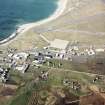
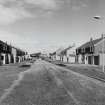
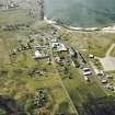
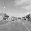
View of staff housing from S.
View in Canmore
View in Canmore

Oblique aerial view centred on the airfield with the township adjacent, taken from the SW.
View in Canmore
View in Canmore

General view of station from SW.
View in Canmore
View in Canmore

View of station from SSW.
View in Canmore
View in Canmore

General view of station from ESE.
View in Canmore
View in Canmore

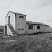
Detail of nissen huts on SE perimeter.
View in Canmore
View in Canmore

Oblique aerial view.
View in Canmore
View in Canmore

Oblique aerial view centred on the village with the airfield adjacent, taken from the SE.
View in Canmore
View in Canmore

General oblique aerial view centred on the airfield, taken from the W.
View in Canmore
View in Canmore

Oblique aerial view centred on the village with the airfield adjacent, taken from the SE.
View in Canmore
View in Canmore

View of station from SSW.
View in Canmore
View in Canmore

View over airfield from ESE from roof of station.
View in Canmore
View in Canmore

View over airfield from ESE from roof of station.
View in Canmore
View in Canmore

View of officers mess from W.
View in Canmore
View in Canmore

Interior.
View of main access corridor from E.
View in Canmore
View in Canmore

View of former WW11 guardroom on SW perimeter from SE.
View in Canmore
View in Canmore

Oblique aerial view.
View in Canmore
View in Canmore

Oblique aerial view centred on the village with the airfield adjacent, taken from the N.
View in Canmore
View in Canmore

View of security gate from SSW.
View in Canmore
View in Canmore

General view of station from SW.
View in Canmore
View in Canmore

View of W side of station from NW.
View in Canmore
View in Canmore

View of 'Winfield Way' staff housing from North East
View in Canmore
View in Canmore

Oblique aerial view centred on Balivanich village with Benbecula airfield adjacent, taken from the S.
View in Canmore
View in Canmore

View of W side of station from SW.
View in Canmore
View in Canmore

View of E side of station from NNE.
View in Canmore
View in Canmore

View over airfield from ESE.
View in Canmore
View in Canmore

Interior.
View of guardroom/security office from N.
View in Canmore
View in Canmore

Oblique aerial view.
View in Canmore
View in Canmore

Oblique aerial view.
View in Canmore
View in Canmore

Oblique aerial view.
View in Canmore
View in Canmore

Oblique aerial view.
View in Canmore
View in Canmore

General oblique aerial view looking over Balvanich and Benbecula airport, towards Grimsey in the distance, taken from the W.
View in Canmore
View in Canmore

General oblique aerial view looking over Benbecula airport and Gramasdail towards The Little Minch beyond, taken from the NNW.
View in Canmore
View in Canmore

View of main entrance gate from SSW.
View in Canmore
View in Canmore

View of security gate from SSW.
View in Canmore
View in Canmore

View of W side of station from SW.
View in Canmore
View in Canmore

Interior.
View of guardroom/security office from N.
View in Canmore
View in Canmore

View of officers mess from NNW.
View in Canmore
View in Canmore

Detail of nissen huts on SE perimeter.
View in Canmore
View in Canmore

Detail of nissen huts on SE perimeter.
View in Canmore
View in Canmore

General oblique aerial view centred on the airfield, taken from the W.
View in Canmore
View in Canmore

View of main entrance gate from SSW.
View in Canmore
View in Canmore

View of W side of station from NW.
View in Canmore
View in Canmore

Interior.
View of entrance hall and turnstile from N (staff side).
View in Canmore
View in Canmore

View of staff housing from S.
View in Canmore
View in Canmore

Oblique aerial view.
View in Canmore
View in Canmore

Oblique aerial view.
View in Canmore
View in Canmore

Oblique aerial view.
View in Canmore
View in Canmore

Oblique aerial view centred on the airfield with the township adjacent, taken from the SW.
View in Canmore
View in Canmore


You may copy, display, store and make derivative works for personal use or use solely within an educational institution by staff and students, under these conditions: the ScotlandsPlaces website is attributed, there is no commercial use or sale, and no public distribution (for example, by hand, email, or web). Full licence details.
Details
Organisation: Historic Environment Scotland (HES)
Alternative name(s): Balivanich; Raf Benbecula; Benbecula Aerodrome; Port Adhair; Bheinn Na Faoghla
Canmore ID: 90522
Site type: Airfield (20th Century)
County: Inverness-shire
Parish: South Uist
Council: Western Isles