
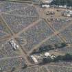
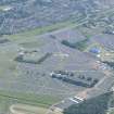
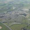
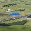
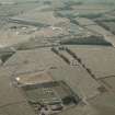
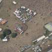
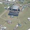
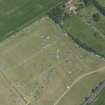
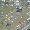
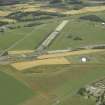
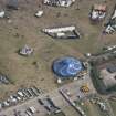
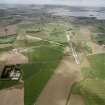
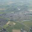
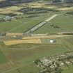
Balado Bridge Airfield


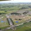
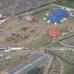
Oblique aerial view of T in the Park at Balado Bridge airfield, taken from the WSW.
View in Canmore
View in Canmore

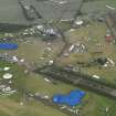
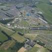
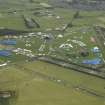
General oblique aerial view of the T in the Park site at Balado Bridge Airfield, looking W.
View in Canmore
View in Canmore

Oblique aerial view of the T in the Park festival at Balado, looking SSW.
View in Canmore
View in Canmore

Oblique aerial view of the T in the Park festival at Balado, looking SSW.
View in Canmore
View in Canmore

Oblique aerial view of the T in the Park festival at Balado, looking S.
View in Canmore
View in Canmore

Oblique aerial view of the T in the Park festival at Balado, looking SSE.
View in Canmore
View in Canmore

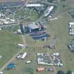
General oblique aerial view centred on the T in the Park festival at Balado, looking NNW.
View in Canmore
View in Canmore

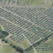
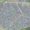
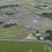
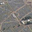
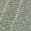
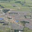
Oblique aerial view of the off-site car parking for T in the Park, looking NW.
View in Canmore
View in Canmore

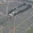
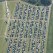
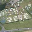
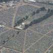
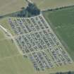
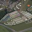
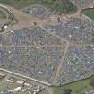
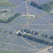
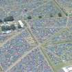
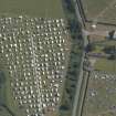
Oblique aerial view of camping at T in the Park, looking SSE.
View in Canmore
View in Canmore

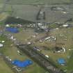
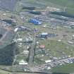
General oblique aerial view of T in the Park, looking SE.
View in Canmore
View in Canmore

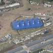
Oblique aerial view of the yurts in The Residence at T in the Park , looking N.
View in Canmore
View in Canmore

Oblique aerial view of camping at T in the Park, looking N.
View in Canmore
View in Canmore

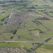
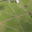
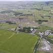
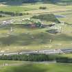
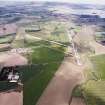
General oblique aerial view centred on Balado Bridge airfield, looking NNW.
View in Canmore
View in Canmore

General oblique aerial view centred on Balado Bridge airfield, looking NW.
View in Canmore
View in Canmore

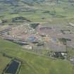
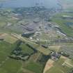
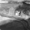
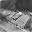
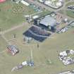
Balado Bridge Radio Station and Airfield, oblique aerial view, taken from the NE, centred on the radio station.
View in Canmore
View in Canmore

Oblique aerial view of the camp site for T in the Park, lookign to the E.
View in Canmore
View in Canmore

General oblique aerial view centred on the T in the Park festival at Balado, looking SW.
View in Canmore
View in Canmore

Oblique aerial view of the T in the Park festival at Balado, looking SSW.
View in Canmore
View in Canmore

Oblique aerial view of the T in the Park festival at Balado, looking SSE.
View in Canmore
View in Canmore

Oblique aerial view of the T in the Park festival at Balado, looking SSE.
View in Canmore
View in Canmore

Oblique aerial view of the T in the Park festival at Balado, looking SE.
View in Canmore
View in Canmore

Oblique aerial view of the T in the Park festival at Balado, looking E.
View in Canmore
View in Canmore

Oblique aerial view of the T in the Park festival at Balado, looking E.
View in Canmore
View in Canmore

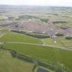
Oblique aerial view of Balado showing T in the Park, looking N.
View in Canmore
View in Canmore

Oblique aerial view of Balado showing T in the Park, looking NE.
View in Canmore
View in Canmore

Oblique aerial view of the off-site car parking for T in the Park, looking NNW.
View in Canmore
View in Canmore

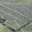
Oblique aerial view of camping at T in the Park, looking SE.
View in Canmore
View in Canmore

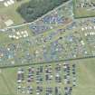
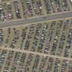
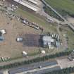
Oblique aerial view of car parking at T in the Park, looking ESE.
View in Canmore
View in Canmore

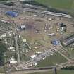
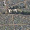
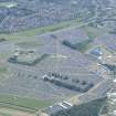
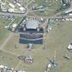
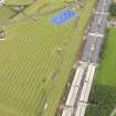
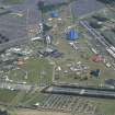
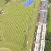
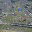
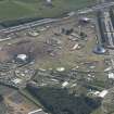
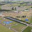
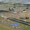
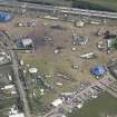
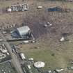
Oblique aerial view of T in the Park centred on the Main Stage, looking ENE.
View in Canmore
View in Canmore

Oblique aerial view of camping at T in the Park.
View in Canmore
View in Canmore

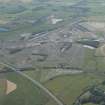
General oblique aerial view of the remains of the airfield and T in the Park, taken from the E.
View in Canmore
View in Canmore

Oblique aerial view of T in the Park at Balado Bridge airfield, taken from the W.
View in Canmore
View in Canmore

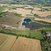
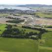
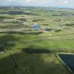
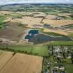
General oblique aerial view of T in the Park with Loch Leven beyond, looking to the ESE.
View in Canmore
View in Canmore

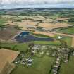
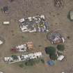
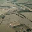
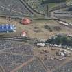
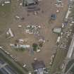
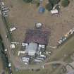
General oblique aerial view of Toll House Poultry Farm and the preparations for T-in-the-Park, taken from the WSW.
View in Canmore
View in Canmore

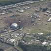
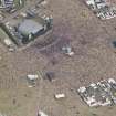
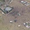
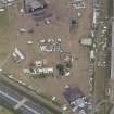
General oblique aerial view of the aftermath of T in the Park, looking NNW.
View in Canmore
View in Canmore

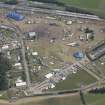
Oblique aerial view of the T in the Park festival at Balado, looking SE.
View in Canmore
View in Canmore

Oblique aerial view of the T in the Park festival at Balado, looking NNE.
View in Canmore
View in Canmore

Oblique aerial view of the T in the Park festival at Balado, looking NNE.
View in Canmore
View in Canmore

Oblique aerial view of car parking at T in the Park, looking SE.
View in Canmore
View in Canmore

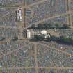
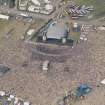
Oblique aerial view of T in the Park centred on the Main Stage with King Tuts Wah Wah Tent beyond, looking SE.
View in Canmore
View in Canmore

Oblique aerial view of T in the Park centred on the Main Stage, looking NE.
View in Canmore
View in Canmore

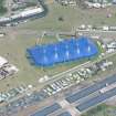
Oblique aerial view of T in the Park centred on the Radio 1 Stage, looking NNE.
View in Canmore
View in Canmore

Balado Bridge Radio Station and Airfield, oblique aerial view, taken from the SSE, centred on the radio station.
View in Canmore
View in Canmore

General oblique aerial view of the remains of the airfield and T in the Park, taken from the E.
View in Canmore
View in Canmore

Oblique aerial view of T in the Park, looking to the NE.
View in Canmore
View in Canmore

General oblique aerial view of Toll House Poultry Farm and the preparations for T-in-the-Park, taken from the W.
View in Canmore
View in Canmore

Oblique aerial view of the T in the Park festival at Balado, looking E.
View in Canmore
View in Canmore

Oblique aerial view of the T in the Park festival at Balado, looking NNE.
View in Canmore
View in Canmore

General oblique aerial view of T in the Park, looking SSE.
View in Canmore
View in Canmore

Oblique aerial view of T in the Park centred on the Main Stage with King Tuts Wah Wah Tent beyond, looking ESE.
View in Canmore
View in Canmore

Oblique aerial view of a camp site at T in the Park, looking NE.
View in Canmore
View in Canmore

Oblique aerial view of T in the Park centred on the Main Stage, looking E.
View in Canmore
View in Canmore

Oblique aerial view of T in the Park centred on the Main Stage, looking NE.
View in Canmore
View in Canmore

Balado Bridge Radio Station and Airfield, oblique aerial view, taken from the NNW, centred on the radio station.
View in Canmore
View in Canmore

Balado Bridge Radio Station and Airfield, oblique aerial view, taken from the W, centred on the radio station.
View in Canmore
View in Canmore

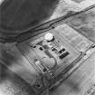
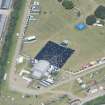
Scanned image of oblique aerial view showing Bridge, SATCOM III satellite tracking station and part of the WW II Airfield taken from the ESE, centred on the tracking station.
View in Canmore
View in Canmore

General oblique aerial view centred on the radio station and airfield with the aircraft hangars in the distance, taken from the SSE.
View in Canmore
View in Canmore

General oblique aerial view centred on the T in the Park festival at Balado, looking SW.
View in Canmore
View in Canmore

Oblique aerial view of the T in the Park festival at Balado, looking SSW.
View in Canmore
View in Canmore

Oblique aerial view of the T in the Park festival at Balado, looking SSW.
View in Canmore
View in Canmore

Oblique aerial view of the T in the Park festival at Balado, looking SE.
View in Canmore
View in Canmore

Oblique aerial view of the T in the Park festival at Balado, looking NNE.
View in Canmore
View in Canmore

Oblique aerial view of the T in the Park festival at Balado, looking NNE.
View in Canmore
View in Canmore

Oblique aerial view of Balado showing T in the Park, looking NNE.
View in Canmore
View in Canmore

Oblique aerial view of T in the Park centred on the Main Stage with King Tuts Wah Wah Tent beyond, looking SSE.
View in Canmore
View in Canmore

Oblique aerial view of camping at T in the Park, looking SE.
View in Canmore
View in Canmore

Oblique aerial view of T in the Park centred on the Main Stage, looking NNE.
View in Canmore
View in Canmore

Oblique aerial view of T in the Park centred on the Main Stage, looking NNE.
View in Canmore
View in Canmore

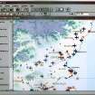
Scanned image of GIS distribution map (arcview) of World War II sites in the Fife and Angus areas of Scotland. The distribution is of airfields, anti-aircraft batteries, radar stations, radio stations and military camps.
View in Canmore
View in Canmore

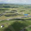
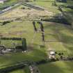
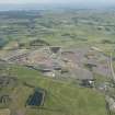
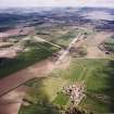
Oblique aerial view looking across the farmsteading, airfield and radio station towards Kinross, taken from the W.
View in Canmore
View in Canmore

Oblique aerial view of T in the Park, looking to the E.
View in Canmore
View in Canmore

General oblique aerial view of the aftermath of T in the Park, looking N.
View in Canmore
View in Canmore

General oblique aerial view of the aftermath of T in the Park, looking N.
View in Canmore
View in Canmore

General oblique aerial view centred on the T in the Park festival at Balado, looking WSW.
View in Canmore
View in Canmore

Oblique aerial view of the T in the Park festival at Balado, looking S.
View in Canmore
View in Canmore

Oblique aerial view of the T in the Park festival at Balado, looking ENE.
View in Canmore
View in Canmore

Oblique aerial view of the T in the Park festival at Balado, looking NE.
View in Canmore
View in Canmore

Oblique aerial view of Balado showing T in the Park, looking NNE.
View in Canmore
View in Canmore

Oblique aerial view of car parking at T in the Park.
View in Canmore
View in Canmore

Oblique aerial view of T in the Park centred on King Tuts Wah Wah Tent, looking NNE.
View in Canmore
View in Canmore

Oblique aerial view of camping at T in the Park.
View in Canmore
View in Canmore

General oblique aerial view centred on Balado Bridge airfield, looking NNW.
View in Canmore
View in Canmore

General oblique aerial view centred on the radio station and airfield with the aircraft hangars in the distance, taken from the SSE.
View in Canmore
View in Canmore

Oblique aerial view of T in the Park, looking to the E.
View in Canmore
View in Canmore

Oblique aerial view of the T in the Park campsite, looking to the WSW.
View in Canmore
View in Canmore

Oblique aerial view of the T in the Park festival at Balado, looking SSE.
View in Canmore
View in Canmore

Oblique aerial view of the T in the Park festival at Balado, looking SSE.
View in Canmore
View in Canmore

General oblique aerial view centred on the T in the Park festival at Balado, looking NNW.
View in Canmore
View in Canmore

Oblique aerial view of the T in the Park festival at Balado, looking E.
View in Canmore
View in Canmore

General oblique aerial view centred on the radio station and airfield with the aircraft hangars in the distance, taken during T in the Park from the W.
View in Canmore
View in Canmore

Oblique aerial view of the T in the Park festival at Balado, looking S.
View in Canmore
View in Canmore

Oblique aerial view of the T in the Park festival at Balado, looking SSE.
View in Canmore
View in Canmore

General oblique aerial view centred on the T in the Park festival at Balado, looking NNW.
View in Canmore
View in Canmore

Oblique aerial view of the T in the Park festival at Balado, looking NNE.
View in Canmore
View in Canmore

General oblique aerial view looking across the farmsteading, airfield and radio station towards Kinross, taken from the W.
View in Canmore
View in Canmore

General oblique aerial view looking across the farmsteading, airfield and radio station towards Kinross, taken from the WSW.
View in Canmore
View in Canmore

You may copy, display, store and make derivative works for personal use or use solely within an educational institution by staff and students, under these conditions: the ScotlandsPlaces website is attributed, there is no commercial use or sale, and no public distribution (for example, by hand, email, or web). Full licence details.
Details
Organisation: Historic Environment Scotland (HES)
Alternative name(s): Raf Balado Bridge; T In The Park
Canmore ID: 90519
Site type: Airfield (20th Century)
County: Kinross-shire
Parish: Kinross
Council: Perth And Kinross