
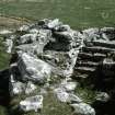
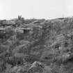
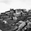
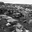
Wag Of Forse


Oblique aerial view.
View in Canmore
View in Canmore


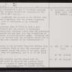
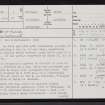
Wag Of Forse, ND23NW 1, Ordnance Survey index card, page number 3, Recto
View in Canmore
View in Canmore

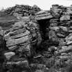
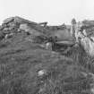
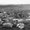
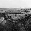
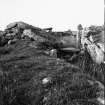
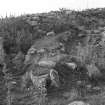
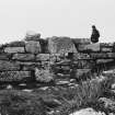
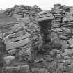
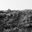
Wag of Forse
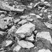
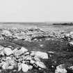
General view
View in Canmore
View in Canmore

Oblique aerial view.
View in Canmore
View in Canmore

Oblique aerial view.
View in Canmore
View in Canmore

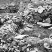
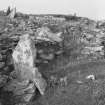
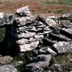
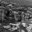
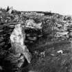
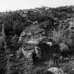
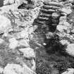
Wag of Forse
General view
View in Canmore
View in Canmore

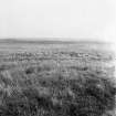
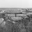
Wag of Forse
General view
View in Canmore
View in Canmore

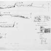
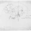
Sections and entrance elevations. Copied 1996.
View in Canmore
View in Canmore

Oblique aerial view.
View in Canmore
View in Canmore

Oblique aerial view.
View in Canmore
View in Canmore

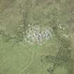
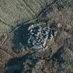
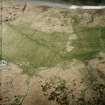
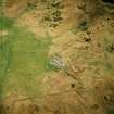
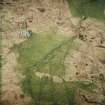
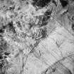
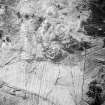
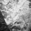
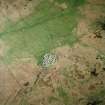
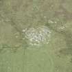
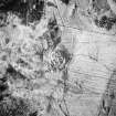
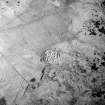
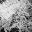
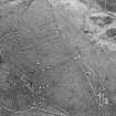
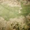
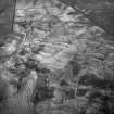
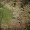
Oblique aerial view centred on the remains of the farmstead and field system with dun, settlement, hut-circle and burnt mounds adjacent, taken from the W.
View in Canmore
View in Canmore


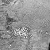
Oblique aerial view centred on the remains of the dun, settlement and field system with hut-circle and farmstead adjacent, taken from the NE.
View in Canmore
View in Canmore

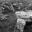
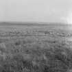
Wag of Forse
General view
View in Canmore
View in Canmore

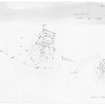
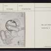
Plan. Copied 1996.
View in Canmore
View in Canmore

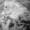
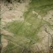
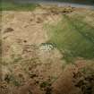
Oblique aerial view centred on the remains of the farmstead and field system with dun, settlement and burnt mounds adjacent, taken from the SSE.
View in Canmore
View in Canmore


Oblique aerial view.
View in Canmore
View in Canmore

Oblique aerial view.
View in Canmore
View in Canmore

Oblique aerial view.
View in Canmore
View in Canmore


Wag of Forse
General view
View in Canmore
View in Canmore

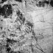
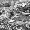
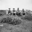
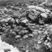
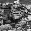
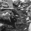
Excavation photograph. The Staff, July 1939. One figure marked with initials 'H I'.
View in Canmore
View in Canmore

Oblique aerial view centred on the remains of the dun, settlement and field system with hut-circle and farmstead adjacent, taken from the NW.
Digital copy of photograph.
View in Canmore
View in Canmore

Oblique aerial view.
View in Canmore
View in Canmore

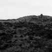
Wag of Forse
General view
View in Canmore
View in Canmore

Oblique aerial view.
View in Canmore
View in Canmore

Oblique aerial view.
View in Canmore
View in Canmore

Oblique aerial view centred on the remains of the dun, settlement and field system with hut-circle and farmstead adjacent, taken from the NW.
View in Canmore
View in Canmore

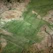
Oblique aerial view centred on the remains of the dun, settlement and field system with hut-circle and farmstead adjacent, taken from the W.
View in Canmore
View in Canmore

Oblique aerial view centred on the remains of the dun, settlement and field system with hut-circle and farmstead adjacent, taken from the NNW.
View in Canmore
View in Canmore


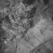
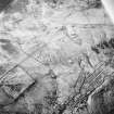
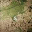
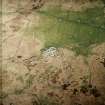
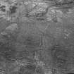
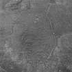
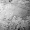
Aerial photograph, origin unknown - part of R J Mercer Caithness survey archive.
View in Canmore
View in Canmore

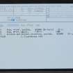
Wag Of Forse, ND23NW 1, Ordnance Survey index card, Recto
View in Canmore
View in Canmore

Wag Of Forse, ND23NW 1, Ordnance Survey index card, Recto
View in Canmore
View in Canmore

Wag of Forse
General view
View in Canmore
View in Canmore

Wag of Forse
General view
View in Canmore
View in Canmore

Wag of Forse
General view
View in Canmore
View in Canmore

Wag of Forse
General view
View in Canmore
View in Canmore

Wag of Forse
General view
View in Canmore
View in Canmore

Wag of Forse
General view
View in Canmore
View in Canmore

Wag of Forse
General view
View in Canmore
View in Canmore

Oblique aerial view.
View in Canmore
View in Canmore


Aerial photograph, origin unknown - part of R J Mercer Caithness survey archive.
View in Canmore
View in Canmore

Aerial photograph, origin unknown - part of R J Mercer Caithness survey archive.
View in Canmore
View in Canmore

Wag Of Forse, ND23NW 1, Ordnance Survey index card, Recto
View in Canmore
View in Canmore

Oblique aerial view centred on the remains of the farmstead and field system with dun, settlement, hut-circle and burnt mounds adjacent, taken from the W.
View in Canmore
View in Canmore

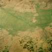
Oblique aerial view centred on the remains of the farmsteads, field system and burnt mounds, taken from the SE.
View in Canmore
View in Canmore

Wag of Forse
General view
View in Canmore
View in Canmore

Plan. Copied 1996.
View in Canmore
View in Canmore

Oblique aerial view centred on the remains of the farmstead and field system with dun, settlement, hut-circle and burnt mounds adjacent, taken from the W.
View in Canmore
View in Canmore

Oblique aerial view centred on the remains of the farmsteads, field system and burnt mounds, taken from the SE.
View in Canmore
View in Canmore


Aerial photograph, origin unknown - part of R J Mercer Caithness survey archive.
View in Canmore
View in Canmore

Wag Of Forse, ND23NW 1, Ordnance Survey index card, Recto
View in Canmore
View in Canmore

Oblique aerial view.
View in Canmore
View in Canmore

Wag of Forse
General view
View in Canmore
View in Canmore

Oblique aerial view centred on the remains of the dun, settlement and field system with hut-circle and farmstead adjacent, taken from the NE.
View in Canmore
View in Canmore

Oblique aerial view centred on the remains of the dun and settlement with field system and hut circle adjacent, taken from the WSW.
View in Canmore
View in Canmore

Oblique aerial view centred on the remains of the dun, settlement and field system with hut-circle and farmstead adjacent, taken from the WNW.
View in Canmore
View in Canmore


Wag Of Forse, ND23NW 1, Ordnance Survey index card, page number 1, Recto
View in Canmore
View in Canmore

Wag Of Forse, ND23NW 1, Ordnance Survey index card, page number 2, Verso
View in Canmore
View in Canmore

Wag Of Forse, ND23NW 1, Ordnance Survey index card, Recto
View in Canmore
View in Canmore

Wag of Forse
General view
View in Canmore
View in Canmore
You may copy, display, store and make derivative works for personal use or use solely within an educational institution by staff and students, under these conditions: the ScotlandsPlaces website is attributed, there is no commercial use or sale, and no public distribution (for example, by hand, email, or web). Full licence details.