
Mid Bracco


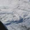
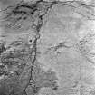
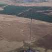
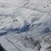
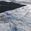
Oblique aerial view centred on the snow-covered remains of the farmsteads, enclosures and rig, taken from the NE.
View in Canmore
View in Canmore

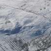
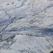
Oblique aerial view centred on the snow-covered remains of the farmsteads, enclosures and rig, taken from the NNE.
View in Canmore
View in Canmore

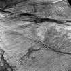
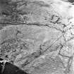
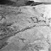
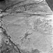
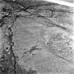
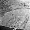
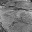
Mid Bracco, oblique aerial view, taken from the SSW, showing the traces of huts, enclosures and a building in the centre, and a field system across the rest of the photograph.,
View in Canmore
View in Canmore

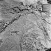
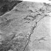
Mid Bracco, oblique aerial view, taken from the ESE, showing the remains of buildings, huts, enclosures and a farmstead in the centre, and field-systems across the remainder of the photograph.
View in Canmore
View in Canmore

Mid Bracco, oblique aerial view, taken from the SSE, showing the remains of buildings, huts and enclosures in the top right-hand corner, and field-systems across the rest of the photograph.
View in Canmore
View in Canmore

Mid Bracco, oblique aerial view, taken from the NE, showing the remains of buildings, huts, enclosures and a farmstead running across the centre of the photograph, and field-systems at the top and bottom.
View in Canmore
View in Canmore

Mid Bracco, oblique aerial view, taken from the N, showing the remains of buildings, huts and enclosures in the centre of the photograph, and field-systems at the top right-hand corner and bottom.
View in Canmore
View in Canmore

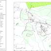
Publication Drawing: 'Plan of Mid Bracco farmstead, compiled from ground survey, aerial photographs and OS map detail'.
View in Canmore
View in Canmore

Mid Bracco and Blackhill, oblique aerial view, taken from the SE, showing the remains of huts, enclosures and field systems at Mid Bracco in the centre of the photograph, and Blackhill enclosures in the centre of the photograph.
View in Canmore
View in Canmore

Oblique aerial view centred on the snow-covered remains of the farmsteads, enclosures and rig, taken from the NNE.
View in Canmore
View in Canmore

Mid Bracco, oblique aerial view, taken from the E, showing the remains of buildings, huts, enclosures and a farmstead in the centre, and field-systems across most of the remainder of the photograph.
View in Canmore
View in Canmore

Mid Bracco, oblique aerial view, taken from the SE, showing the remains of buildings, huts and enclosures in the right of the photograph, field-systems in the centre, and the traces of a farmstead in the top right-hand corner.
View in Canmore
View in Canmore

Mid Bracco, oblique aerial view, taken from the S, showing the remains of buildings, huts and enclosures in the centre of the photograph, and field-systems in the top and bottom.
View in Canmore
View in Canmore

Mid Bracco, oblique aerial view, taken from the SSE, showing the remains of buildings, huts and enclosures in the centre of the photograph, and field-systems in the top right-hand corner and bottom left-hand corner.
View in Canmore
View in Canmore

Mid Bracco, oblique aerial view, taken from the ENE, showing the remains of buildings, huts and enclosures in the centre right of the photograph, and field-systems at the top and bottom left-hand corner.
View in Canmore
View in Canmore

Oblique aerial view centred on the snow-covered remains of the farmsteads, enclosures and rig, taken from the NNE.
View in Canmore
View in Canmore

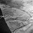
General oblique aerial view centred on the snow-covered remains of the farmsteads, enclosures and rig, taken from the NW.
View in Canmore
View in Canmore

Mid Bracco, oblique aerial view, taken from the SSW, showing the traces of huts, enclosures and a building in the centre, and a field system across the rest of the photograph.,
View in Canmore
View in Canmore
You may copy, display, store and make derivative works for personal use or use solely within an educational institution by staff and students, under these conditions: the ScotlandsPlaces website is attributed, there is no commercial use or sale, and no public distribution (for example, by hand, email, or web). Full licence details.
Details
Organisation: Historic Environment Scotland (HES)
Alternative name(s):
Canmore ID: 83272
Site type: Archaeological Landscape (medieval) - (post Medieval)
County: Lanarkshire
Parish: Shotts (monklands)
Council: North Lanarkshire