
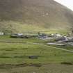
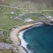
St Kilda, Hirta, Village Bay, Ministry Of Defence Establishment


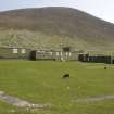
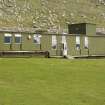
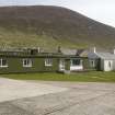
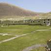
Village Bay, Ministry of Defence Establishment. View of main accommodation block from NE.
View in Canmore
View in Canmore

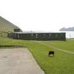
Village Bay, Ministry of Defence Establishment. View of main accommodation block from SW, including the Puff Inn.
View in Canmore
View in Canmore

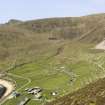
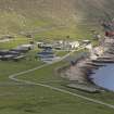
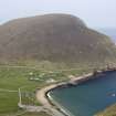
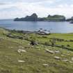
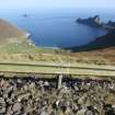
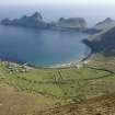
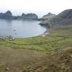
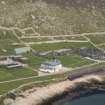
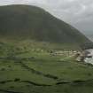
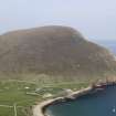
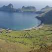
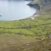
Hirta, Village Bay. General view from SW including the Ministry of Defence Establishment, An Lag and The Gap, with Boreray beyond.
View in Canmore
View in Canmore

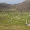
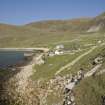
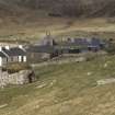
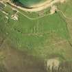
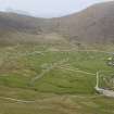
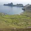
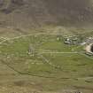
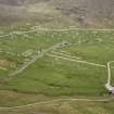
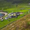
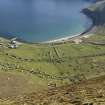
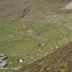
Hirta, Village Bay. General view from SE showing the Street, crofts and head dyke, and including the Ministry of Defence Establishment and the radar station on Mullach Mor.
View in Canmore
View in Canmore

Village Bay, Hirta, St Kilda.
General view from N with cleit in foreground, including the Ministry of Defence Establishment, the radar station on Mullach Sgar and Dun beyond.
View in Canmore
View in Canmore

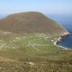
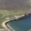
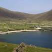
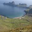
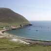
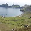
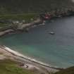
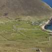
General view of Village Bay, St Kilda, looking E.
View in Canmore
View in Canmore

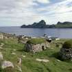
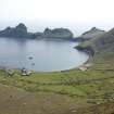
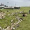
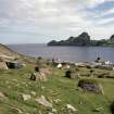
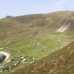
St Kilda, Village Bay. General view of cleitean, military base and Dun, facing south east, with cleitean 34 and 35 over old head dyke in the foreground.
View in Canmore
View in Canmore

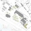
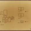
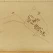
St Kilda, General Layout of Domestic SIte, with contours.
View in Canmore
View in Canmore

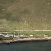
Ministry of Defence Establishment, the Puff Inn. View from SW, including part of main accommodation block.
View in Canmore
View in Canmore

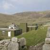
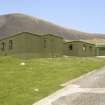
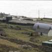
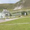
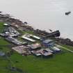
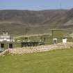
Village Bay, Ministry of Defence Establishment. View of office block, garages and stores from S.
View in Canmore
View in Canmore

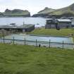
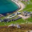
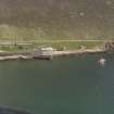
Village Bay, Ministry of Defence Establishment. General elevated view from NW, including the church and manse, the Feather Store, quay and the Spinningdale.
View in Canmore
View in Canmore

Village Bay, Ministry of Defence Establishment. General view from SW, including the Factor's House, quay, church and Feather Store.
View in Canmore
View in Canmore

Village Bay, Ministry of Defence Establishment. Elevated distant view from SW.
View in Canmore
View in Canmore

Village Bay, Ministry of Defence Establishment. Elevated general view from SW, including including the Factor's House, quay, manse, the Feather Store and the Spinningdale.
View in Canmore
View in Canmore

Village Bay, Ministry of Defence Establishment. General view from E, including the gun emplacement, Feather Store, church and manse.
View in Canmore
View in Canmore

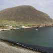
Hirta, Village Bay. General view from W including the Ministry of Defence Establishment.
View in Canmore
View in Canmore

General view from NW.
View in Canmore
View in Canmore

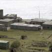
View of the military base, St Kilda. Copied from a slide in the collection of G Stell.
View in Canmore
View in Canmore

View of the military base, St Kilda. Copied from a slide in the collection of G Stell.
View in Canmore
View in Canmore

General view of the military base and Dun
View in Canmore
View in Canmore

General view of the village, military base and Dun
View in Canmore
View in Canmore

Vertical aerial photograph showing St Kilda.
View in Canmore
View in Canmore

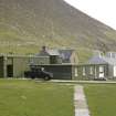
Village Bay, St Kilda, Ministry of Defence Establishment. View of the officer's mess (1962) from WSW with the whitewashed manse (1827-8) adjoining.
View in Canmore
View in Canmore

Village Bay, Ministry of Defence Establishment. View of main accommodation block from NW.
View in Canmore
View in Canmore

Village Bay, Ministry of Defence Establishment. General view from NW, including the Factor's House, the Feather Store, church and manse, quay and the Spinningdale.
View in Canmore
View in Canmore

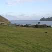
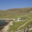
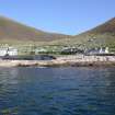
Hirta, Village Bay. General view from SW across the bay, including the Ministry of Defence Establishment.
View in Canmore
View in Canmore

Hirta, Village Bay. General view from N, including the Ministry of Defence Establishment, with Dun beyond.
View in Canmore
View in Canmore

Hirta, Village Bay. General view from N, including the Ministry of Defence Establishment, with Dun beyond.
View in Canmore
View in Canmore

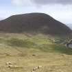
General view of Village Bay and Dun from the road to Mullach Geal, St Kilda.
View in Canmore
View in Canmore

Vertical aerial photograph of St Kilda, taken at the beginning of Operation Hardrock when only the advance party was on island. Scanned image of 58/RAF/2147/F22/0053.
View in Canmore
View in Canmore

Publication Illustration: St Kilda, phased plan of the military base,
View in Canmore
View in Canmore

Hirta, Village Bay. General view from N, including the Ministry of Defence Establishment, with Dun beyond.
View in Canmore
View in Canmore

Hirta, Village Bay. General view from N, including the Ministry of Defence Establishment, with Dun beyond.
View in Canmore
View in Canmore

Hirta, Village Bay. General view from SW including the Ministry of Defence Establishment, An Lag and The Gap, with Boreray beyond.
View in Canmore
View in Canmore

Hirta, Village Bay. General view from SE showing the Street, crofts and head dyke, and including the Ministry of Defence Establishment and the radar station on Mullach Mor.
View in Canmore
View in Canmore

Hirta, Village Bay. General view from N, including the Ministry of Defence Establishment, with Dun beyond.
View in Canmore
View in Canmore

Hirta, Village Bay. General view from N, including the Ministry of Defence Establishment and the radar station on Mullach Sgar, with Dun beyond.
View in Canmore
View in Canmore

Hirta, Village Bay. General view from N, including the Ministry of Defence Establishment, with Dun beyond.
View in Canmore
View in Canmore

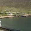
Village Bay, Ministry of Defence Establishment. General view across the bay from SW.
View in Canmore
View in Canmore

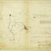
St Kilda - Location Plan showing proposed road and areas for acquisition.
View in Canmore
View in Canmore

St Kilda, plans of blocks 31, 32, 49 and 50 (factor's house, ablutions block, church and manse).
View in Canmore
View in Canmore

Village Bay, Ministry of Defence Establishment. Elevated general view from W, including the Factor's House, church and manse.
View in Canmore
View in Canmore

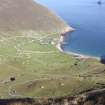
Village Bay, Abhainn Ilishgil. General view of the 'Dry Burn' from NNE, including cleits 24-25 and 27, with the Ministry of Defence office block, garages and stores in the background.
View in Canmore
View in Canmore

Hirta, Village Bay. General view from N, including the Ministry of Defence Establishment, with Dun beyond.
View in Canmore
View in Canmore

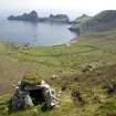
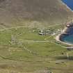
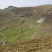
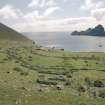
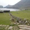
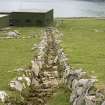
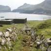
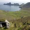
St Kilda, Village Bay. General view of cleitean and enclosures above head dyke.
View in Canmore
View in Canmore

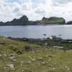
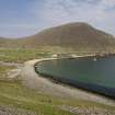
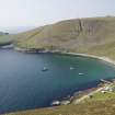
View E across Village Bay
View in Canmore
View in Canmore

A new block being constructed within the military base
View in Canmore
View in Canmore

Village Bay, Ministry of Defence Establishment. View of main accommodation block, manse and church from W.
View in Canmore
View in Canmore

Village Bay, Abhainn Ilishgil. View of the 'Dry Burn' from NNE, with the Ministry of Defence office block, garages and stores in the background.
View in Canmore
View in Canmore

Village Bay, Ministry of Defence Establishment. General view from E, including the gun emplacement, Feather Store, church and manse.
View in Canmore
View in Canmore

Village Bay, Ministry of Defence Establishment. General view from E, including the gun emplacement, Feather Store, church and manse.
View in Canmore
View in Canmore

Hirta, Village Bay. General view from W including the Ministry of Defence Establishment.
View in Canmore
View in Canmore

2009-05 Village Bay.
View in Canmore
View in Canmore

General view of Village Bay, St Kilda, looking E.
View in Canmore
View in Canmore

St Kilda, Village Bay. General view of cleitean, military base and Dun, facing south east, with the old head dyke in the foreground.
View in Canmore
View in Canmore

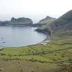
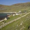
St Kilda, Village Bay. General view of military base, church, quay and storehouse.
View in Canmore
View in Canmore

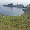
St Kilda, Village Bay. General view looking east across village bay to the military base.
View in Canmore
View in Canmore

View of the military base, St Kilda. Copied from a slide in the collection of G Stell.
View in Canmore
View in Canmore

View of the floor of the former sports hall during construction work
View in Canmore
View in Canmore

General view
View in Canmore
View in Canmore

Village Bay, Ministry of Defence Establishment. View of main accommodation block from E.
View in Canmore
View in Canmore

Village Bay, Ministry of Defence Establishment. View of main accommodation block from SSW, including the Puff Inn.
View in Canmore
View in Canmore

Village Bay, Ministry of Defence Establishment. General elevated view from N, including the Factor's House, church and manse, the Feather Store and quay.
View in Canmore
View in Canmore

Village Bay, Ministry of Defence Establishment. Distant view across the bay from W.
View in Canmore
View in Canmore

Village Bay, Ministry of Defence Establishment. Elevated distant view from WNW.
View in Canmore
View in Canmore

Village Bay, Abhainn Ilishgil. View of the 'Dry Burn' from NNE, with the Ministry of Defence office block, garages and stores in the background.
View in Canmore
View in Canmore

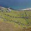
Hirta, Village Bay. General view from SW across the crofts and along the Street, including the Ministry of Defence Establishment.
View in Canmore
View in Canmore

Hirta, Village Bay. General view from SE showing the Street, crofts and head dyke, and including the Ministry of Defence Establishment and the radar station on Mullach Mor.
View in Canmore
View in Canmore

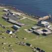
General view of the military base, St Kilda.
View in Canmore
View in Canmore

General view
View in Canmore
View in Canmore

General view
View in Canmore
View in Canmore

Village Bay, Ministry of Defence Establishment. Distant view across the bay from the WNW.
View in Canmore
View in Canmore

Village Bay, Ministry of Defence Establishment. General view from SW, including the quay, manse, the Feather Store and the Spinningdale.
View in Canmore
View in Canmore

Village Bay, Abhainn Ilishgil. View of the 'Dry Burn' from NNE, with the Ministry of Defence office block, garages and stores in the background.
View in Canmore
View in Canmore

Hirta, Village Bay. General view from N, including the Ministry of Defence Establishment.
View in Canmore
View in Canmore

Hirta, Village Bay. General view from N, including the Ministry of Defence Establishment.
View in Canmore
View in Canmore

Hirta, Village Bay. General view from N, including the Ministry of Defence Establishment, with Dun beyond.
View in Canmore
View in Canmore

Hirta, Village Bay. Distant view from W, including the Ministry of Defence Establishment, with Oiseval beyond.
View in Canmore
View in Canmore

Hirta, Village Bay. General view from SE showing the Street, crofts and head dyke, and including the Ministry of Defence Establishment.
View in Canmore
View in Canmore

Village Bay, Ministry of Defence Establishment. General view from NE across the bay, including the radar station on Mullach Sgar and Ruaival.
View in Canmore
View in Canmore

Hirta, Village Bay. General view from N, including the Ministry of Defence Establishment.
View in Canmore
View in Canmore

Hirta, Village Bay. General view from N with cleit in foreground, including the Ministry of Defence Establishment, the radar station on Mullach Sgar and Dun beyond.
View in Canmore
View in Canmore

Hirta, Village Bay. General view from W including the Ministry of Defence Establishment.
View in Canmore
View in Canmore

St Kilda, General Layout of Domestic Site.
View in Canmore
View in Canmore
You may copy, display, store and make derivative works for personal use or use solely within an educational institution by staff and students, under these conditions: the ScotlandsPlaces website is attributed, there is no commercial use or sale, and no public distribution (for example, by hand, email, or web). Full licence details.
Details
Organisation: Historic Environment Scotland (HES)
Alternative name(s):
Canmore ID: 75830
Site type: Military Base (20th Century)
County: Inverness-shire
Parish: Harris
Council: Western Isles