
Dallachy Airfield


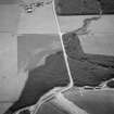
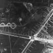
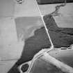
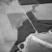
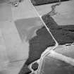
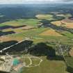
Oblique aerial view centred on the cropmarks of the unenclosed settlement, ring ditches and enclosures at Lower Auchenreath with Dallachy airfield adjacent, looking to the SE.
View in Canmore
View in Canmore

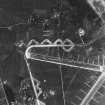
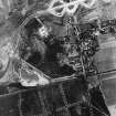
RAF WWII vertical aerial photograph of the NW part of Dallachy Airfield during the construction phase. Visible are part of the main runways, the perimeter track and technical area. Also visible is the small village of Nether Dallachy
View in Canmore
View in Canmore

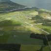
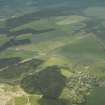
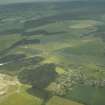
General oblique aerial view centred on the airfield with the villages in the distance, taken from the SE.
View in Canmore
View in Canmore

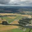
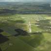
General oblique aerial view centred on the remains of the airfield, taken from the E.
View in Canmore
View in Canmore

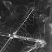
RAF WWII vertical aerial photograph of the main runway crossing point of Dallachy Airfield during the construction phase. Visible are several anti-landing ditches.
View in Canmore
View in Canmore

General oblique aerial view centred on the remains of the airfield, taken from the N.
View in Canmore
View in Canmore

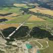
General oblique aerial view centred on Dallachy Airfield, looking NNW.
View in Canmore
View in Canmore

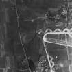
RAF WWII vertical aerial photograph of W part of airfield during the construction phase.Visible are taxiways and part of E-W runway. Also seen on the image is the small village of Nether Dallachy.
View in Canmore
View in Canmore

Oblique aerial view centred on the cropmarks of the unenclosed settlement, ring ditches and enclosures at Lower Auchenreath with Dallachy airfield adjacent, looking to the SE.
View in Canmore
View in Canmore

RAF WWII vertical aerial photograph showing the runways during the construction phase.Also visible are areas of anti-landing ditches on the limits of Spey Bay.
View in Canmore
View in Canmore

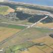
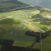
General oblique aerial view centred on the remains of the airfield with the village adjacent, taken from the NNW.
View in Canmore
View in Canmore

General oblique aerial view centred on the airfield with the villages in the distance, taken from the ESE.
View in Canmore
View in Canmore

Oblique aerial view centred on the cropmarks of the unenclosed settlement, ring ditches and enclosures at Lower Auchenreath with Dallachy airfield adjacent, looking to the SE.
View in Canmore
View in Canmore

Oblique aerial view centred on the cropmarks of the unenclosed settlement, ring ditches and enclosures at Lower Auchenreath with Dallachy airfield adjacent, looking to the SE.
View in Canmore
View in Canmore

General oblique aerial view centred on the remains of the airfield with the village adjacent, taken from the NNW.
View in Canmore
View in Canmore

General oblique aerial view centred on the airfield with the villages in the distance, taken from the E.
View in Canmore
View in Canmore

General oblique aerial view centred on the remains of the airfield, taken from the NNW.
View in Canmore
View in Canmore

RAF WWII vertical aerial photograph of the NE part of Dallachy Airfield during the construction phase. Visible is part of the perimeter track and taxiways. Also visible is the small village of Nether Dallachy and an area of freshly dug anti-landing ditches to the NE of the village.
View in Canmore
View in Canmore
You may copy, display, store and make derivative works for personal use or use solely within an educational institution by staff and students, under these conditions: the ScotlandsPlaces website is attributed, there is no commercial use or sale, and no public distribution (for example, by hand, email, or web). Full licence details.
Details
Organisation: Historic Environment Scotland (HES)
Alternative name(s): Raf Dallachy; Moor Of Dallachy; Bogmoor; Nether Dallachy
Canmore ID: 74207
Site type: Airfield (20th Century)
County: Morayshire
Parish: Bellie
Council: Moray