
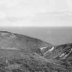
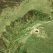
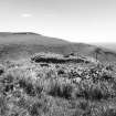
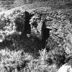
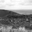
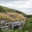
Ousdale Burn


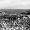
From up slope
View in Canmore
View in Canmore

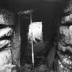
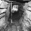
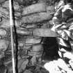
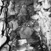
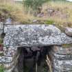
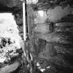
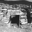
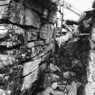
Inside entrance looking out.
View in Canmore
View in Canmore

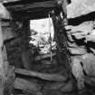
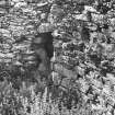
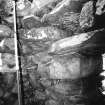
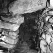
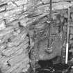
Guard cell.
View in Canmore
View in Canmore

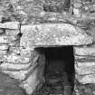
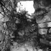
Entrance passage,looking out.
View in Canmore
View in Canmore

Entrance passage,looking in.
View in Canmore
View in Canmore


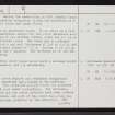
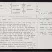
Ousdale Burn, ND01NE 1, Ordnance Survey index card, Recto
View in Canmore
View in Canmore

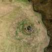
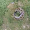
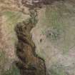
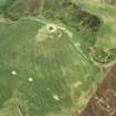
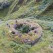
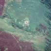
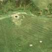
Near vertical aerial view of Ousdale Broch, looking ESE.
View in Canmore
View in Canmore

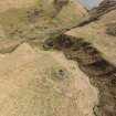
Vertical aerial photograph showing full site extent of Ousdale Burn broch
View in Canmore
View in Canmore

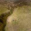
Aerial view of Ousdale Broch, Ousdale Burn, Helmsdale, East Sutherland, looking N.
View in Canmore
View in Canmore

Interior
View in Canmore
View in Canmore

Guard cell with door and entrance.
View in Canmore
View in Canmore

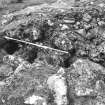
Stair-foot guard cell looking up.
View in Canmore
View in Canmore

Ousdale Burn, ND01NE 1, Ordnance Survey index card, page number 3, Recto
View in Canmore
View in Canmore


Entrance and void above, from interior
View in Canmore
View in Canmore

Stair foot cell.
View in Canmore
View in Canmore


Ousdale Burn, ND01NE 1, Ordnance Survey index card, page number 2, Verso
View in Canmore
View in Canmore

Oblique aerial view of Ousdale Broch, looking south east.
View in Canmore
View in Canmore

Oblique aerial view of Ousdale Broch, looking west.
View in Canmore
View in Canmore

Oblique aerial view of Ousdale Broch, looking west.
View in Canmore
View in Canmore

Detailed view showing lintel stone over main passage entrance at Ousdale Burn broch
View in Canmore
View in Canmore

Aerial view of Ousdale Broch, Helmsdale, East Sutherland, looking SW.
View in Canmore
View in Canmore

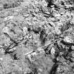
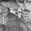
Bar socket and door check.
View in Canmore
View in Canmore

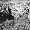
Inside mural cell.
View in Canmore
View in Canmore

Childe Collection
View in Canmore
View in Canmore

Maps of Latheron parish. Negative Available.
View in Canmore
View in Canmore

Maps of Latheron parish. Negative Available.
View in Canmore
View in Canmore

Maps of Latheron parish
View in Canmore
View in Canmore

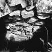
Void over entrance.
View in Canmore
View in Canmore

Remains of chamber over entrance.
View in Canmore
View in Canmore

Looking down into guard cell.
View in Canmore
View in Canmore

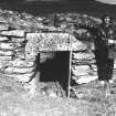
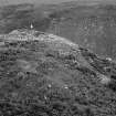
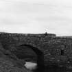
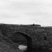
Outer wall with broch entrance behind pole.
View in Canmore
View in Canmore


Ousdale Burn, ND01NE 1, Ordnance Survey index card, Recto
View in Canmore
View in Canmore

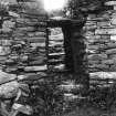
Broch, Ousdale: entrance from interior
View in Canmore
View in Canmore

Aerial view of Ousdale Broch, Helmsdale, East Sutherland, looking SE.
View in Canmore
View in Canmore


Inside cell
View in Canmore
View in Canmore

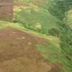
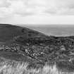
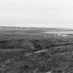
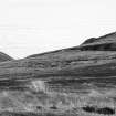
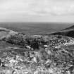
Distant view
View in Canmore
View in Canmore

From the West.
View in Canmore
View in Canmore

Interior.
View in Canmore
View in Canmore

Interior. Shows main door.
View in Canmore
View in Canmore

Stair-foot guard cell looking up the stair.
View in Canmore
View in Canmore


Oblique aerial view of Ousdale Burn broch, facing SE
View in Canmore
View in Canmore

Stair-foot guard cell.
View in Canmore
View in Canmore


Aerial view of Ousdale Broch and Borg township, Ousdale, near Helmsdale, Sutherland, looking NW.
View in Canmore
View in Canmore

Ousdale Burn, ND01NE 1, Ordnance Survey index card, Recto
View in Canmore
View in Canmore

View across Ousdale Burn broch, facing east, including lintel over entrance passage
View in Canmore
View in Canmore

Aerial view of Ousdale Broch, Helmsdale, East Sutherland, looking SSE.
View in Canmore
View in Canmore

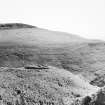
Distant view
View in Canmore
View in Canmore

Stair looking up.
View in Canmore
View in Canmore

General survey area plan.
View in Canmore
View in Canmore

Ousdale Burn, ND01NE 1, Ordnance Survey index card, page number 1, Recto
View in Canmore
View in Canmore


You may copy, display, store and make derivative works for personal use or use solely within an educational institution by staff and students, under these conditions: the ScotlandsPlaces website is attributed, there is no commercial use or sale, and no public distribution (for example, by hand, email, or web). Full licence details.