
Kilphedir


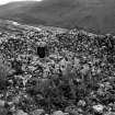
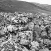
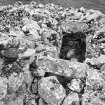
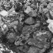
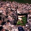
View across broch interior.
View in Canmore
View in Canmore

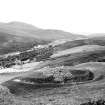
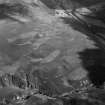
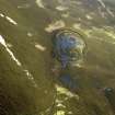
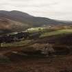
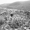
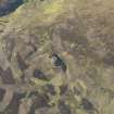
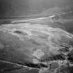
Oblique aerial view centred on Kilphedir Broch with the small cairns and hut-circles adjacent, taken from the SSW.
View in Canmore
View in Canmore


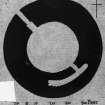
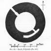
Publication drawing; plan of 'Broch, Kilphedir'.
View in Canmore
View in Canmore

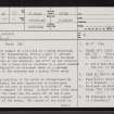
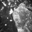
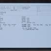
Kilphedir, NC91NE 27, Ordnance Survey index card, page number 1, Recto
View in Canmore
View in Canmore

Kilphedir, NC91NE 27, Ordnance Survey index card, Recto
View in Canmore
View in Canmore

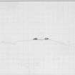
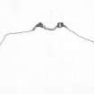
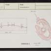
Section across broch at Kilphedir.
View in Canmore
View in Canmore

Section across broch at Kilphedir.
View in Canmore
View in Canmore

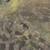
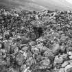
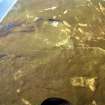
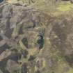
Oblique aerial view.
View in Canmore
View in Canmore


Kilphedir, NC91NE 27, Ordnance Survey index card, Recto
View in Canmore
View in Canmore

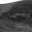
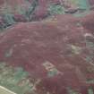
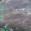
Oblique aerial view centred on the remains of Kilphedir Broch, field system and hut circles, looking to the SE.
View in Canmore
View in Canmore


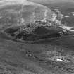
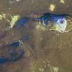
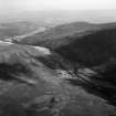
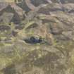
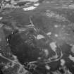
An oblique aerial view of Kilphedir Broch, Strath of Kildonan, East Sutherland, looking E.
View in Canmore
View in Canmore

An oblique aerial view of Kilphedir Broch, Strath of Kildonan, East Sutherland, looking SSE.
View in Canmore
View in Canmore

An oblique aerial view of Kilphedir Broch, Strath of Kildonan, East Sutherland, looking ENE.
View in Canmore
View in Canmore

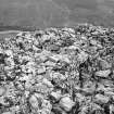
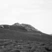
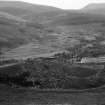
Approach from below
View in Canmore
View in Canmore

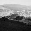
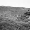
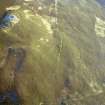
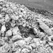
Ditch
View in Canmore
View in Canmore

Aerial view of Kilphedir Broch, near Helmsdale, East Sutherland, looking SE.
View in Canmore
View in Canmore

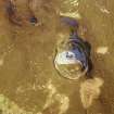
Oblique aerial view.
View in Canmore
View in Canmore

Oblique aerial view centred on Kilphedir Broch with the small cairns and hut-circles adjacent, taken from the ESE.
View in Canmore
View in Canmore

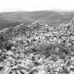
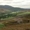
View looking from higher ground onto the Kilphedir broch.
View in Canmore
View in Canmore


An oblique aerial view of Kilphedir Broch, Strath of Kildonan, East Sutherland, looking NNW.
View in Canmore
View in Canmore

Kilphedir, NC91NE 27, Ordnance Survey index card, page number 2, Verso
View in Canmore
View in Canmore

Publication drawing; plan of 'Broch, Kilphedir'.
View in Canmore
View in Canmore

View across broch interior.
View in Canmore
View in Canmore

An oblique aerial view of Kilphedir Broch, Strath of Kildonan, East Sutherland, looking SE.
View in Canmore
View in Canmore

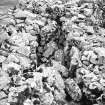
Wall gallery and stair
View in Canmore
View in Canmore

Aerial view of Kilphedir Broch, Cairns and roundhouse settlement, Strath of Kildonan looking NNW.
View in Canmore
View in Canmore

Oblique aerial view centred on the remains of Kilphedir Broch, field system and hut circles, looking to the ESE.
View in Canmore
View in Canmore

Oblique aerial view.
View in Canmore
View in Canmore

Aerial view of Kilphedir Broch, near Helmsdale, East Sutherland, looking NE.
View in Canmore
View in Canmore

Kilphedir, NC91NE 27, Ordnance Survey index card, Recto
View in Canmore
View in Canmore

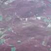
Oblique aerial view centred on Kilphedir Broch with the small cairns and hut-circles adjacent, taken from the S.
View in Canmore
View in Canmore

Oblique aerial view centred on Kilphedir Broch with the small cairns and hut-circles adjacent, taken from the ENE.
View in Canmore
View in Canmore

An oblique aerial view of Kilphedir Broch, Strath of Kildonan, East Sutherland, looking NE.
View in Canmore
View in Canmore

Aerial view of Kilphedir Broch, near Helmsdale, East Sutherland, looking E.
View in Canmore
View in Canmore

View looking from higher ground onto the Kilphedir broch.
View in Canmore
View in Canmore


Oblique aerial view of Kilphedir broch, looking to the NNE.
View in Canmore
View in Canmore

Oblique aerial view centred on the remains of Kilphedir Broch, field system and hut circles, looking to the SSE.
View in Canmore
View in Canmore

Oblique aerial view centred on Kilphedir Broch with the small cairns and hut-circles adjacent, taken from the SSE.
View in Canmore
View in Canmore


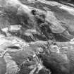
From above
View in Canmore
View in Canmore
You may copy, display, store and make derivative works for personal use or use solely within an educational institution by staff and students, under these conditions: the ScotlandsPlaces website is attributed, there is no commercial use or sale, and no public distribution (for example, by hand, email, or web). Full licence details.
Details
Organisation: Historic Environment Scotland (HES)
Alternative name(s): Kilphader Tower
Canmore ID: 7000
Site type: Broch (iron Age)
County: Sutherland
Parish: Kildonan
Council: Highland