
Liddel Castle


Oblique aerial view.
View in Canmore
View in Canmore

Oblique aerial view.
View in Canmore
View in Canmore

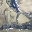
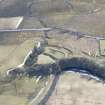
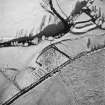
Oblique aerial view of Liddel Castle centred on the remains of an earthwork fortification with a burial ground and remains of a church adjacent, from NW.
View in Canmore
View in Canmore

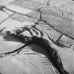
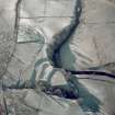
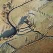
Oblique aerial view of Liddel Castle centred on the remains of an earthwork fortification and burial-ground, from NE.
View in Canmore
View in Canmore

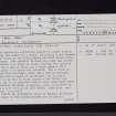
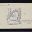
Liddel Castle, NY58NW 2, Ordnance Survey index card, page number 2, Verso
View in Canmore
View in Canmore

Oblique aerial view of Liddel Castle centred on the remains of an earthwork fortification and burial-ground, taken from the NE.
View in Canmore
View in Canmore

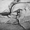
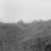
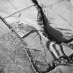
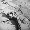
Oblique aerial view of Liddel Castle centred on the remains of an earthwork fortification, taken from the SSE.
View in Canmore
View in Canmore

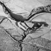
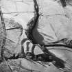
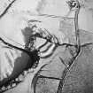
Oblique aerial view of Liddel Castle centred on the remains of an earthwork fortification, taken from the ESE.
View in Canmore
View in Canmore

Liddel Castle, NY58NW 2, Ordnance Survey index card, page number 1, Recto
View in Canmore
View in Canmore

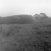
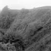
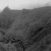
General view.
View in Canmore
View in Canmore

Oblique aerial view.
View in Canmore
View in Canmore

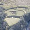
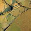
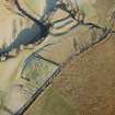
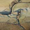
Oblique aerial view of Castleton centred on a burial-ground and remains of an earthwork fortification, taken from the SW. Digital image of D/24606/CN.
View in Canmore
View in Canmore

General view.
View in Canmore
View in Canmore

Oblique aerial view of Liddel Castle centred on the remains of an earthwork fortification with a burial ground and remains of a church adjacent, from ENE.
View in Canmore
View in Canmore

Oblique aerial view of Castleton centred on a burial ground and remains of a church with the remains of an earthwork fortification adjacent, from S.
View in Canmore
View in Canmore

Oblique aerial view of Castleton centred on a burial-ground and remains of an earthwork fortification, from SW.
View in Canmore
View in Canmore

Liddel Castle, NY58NW 2, Ordnance Survey index card, page number 2, Recto
View in Canmore
View in Canmore

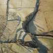
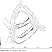
Publication drawing; Plan of Liddle Castle earthworks, redrawn from Inventory illustration [1912] for publication with comparative plans of mottes and medieval earthwork monuments.
View in Canmore
View in Canmore

General view.
View in Canmore
View in Canmore

General view.
View in Canmore
View in Canmore

Oblique aerial view.
View in Canmore
View in Canmore

Oblique aerial view of Castleton centred on a burial ground and remains of a church with the remains of an earthwork fortification adjacent, from E.
View in Canmore
View in Canmore

Oblique aerial view of Liddel Castle centred on the remains of an earthwork fortification with a burial ground and remains of a church adjacent, from NE.
View in Canmore
View in Canmore

Oblique aerial view of Liddel Castle centred on the remains of an earthwork fortification, taken from the SSE.
View in Canmore
View in Canmore

Oblique aerial view of Castleton centred on a burial ground and remains of a church with the remains of an earthwork fortification adjacent, from SSW.
View in Canmore
View in Canmore

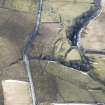
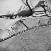
Oblique aerial view of Liddel Castle centred on the remains of an earthwork fortification and burial-ground, from E.
View in Canmore
View in Canmore

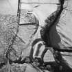
Oblique aerial view of Liddel Castle centred on the remains of an earthwork fortification, taken from the SSW.
View in Canmore
View in Canmore

Oblique aerial view of Liddel Castle centred on the remains of an earthwork fortification with a burial ground and remains of a church adjacent, from WNW.
View in Canmore
View in Canmore

Oblique aerial view of Liddel Castle centred on the remains of an earthwork fortification with a burial ground and remains of a church adjacent, from WSW.
View in Canmore
View in Canmore

You may copy, display, store and make derivative works for personal use or use solely within an educational institution by staff and students, under these conditions: the ScotlandsPlaces website is attributed, there is no commercial use or sale, and no public distribution (for example, by hand, email, or web). Full licence details.
Details
Organisation: Historic Environment Scotland (HES)
Alternative name(s): Liddel Motte; Liddle
Canmore ID: 67934
Site type: Earthwork (period Unassigned), Fortification (period Unassigned), Motte And Bailey (medieval)
County: Roxburghshire
Parish: Castleton
Council: Scottish Borders, The