ScotlandsPlaces Home

Scotlands Places

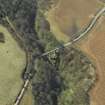
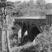
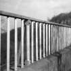
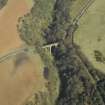
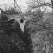
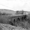
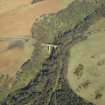
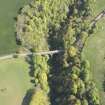
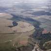
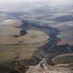
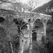
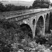
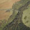
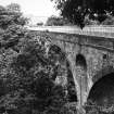
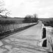
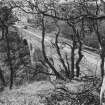
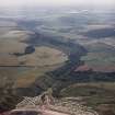
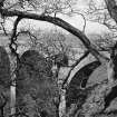
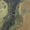
Cockburnspath, Pease Bridge


  • Pease Bridge View looking W along deck John R Hume Date 10/4/1978 Copyright RCAHMS
  • Pease Bridge View showing arches John R Hume Date 10/4/1978 Copyright RCAHMS
  • Pease Bridge View showing arches John R Hume Date 10/4/1978 Copyright RCAHMS
  • Pease Bridge View from ENE showing N front John R Hume Date 10/4/1978 Copyright RCAHMS
  • Oblique aerial view centred on the road bridge, taken from the S. RCAHMS Aerial Photography Digital Date 4/4/2006 Copyright RCAHMS
  • Oblique aerial view centred on the road bridge, taken from the SSW. RCAHMS Aerial Photography Digital Copyright RCAHMS
  • Oblique aerial view centred on the road bridge, taken from the NNW. RCAHMS Aerial Photography Digital Copyright RCAHMS
  • Oblique aerial view centred on the road bridge, taken from the NNE. RCAHMS Aerial Photography Digital Copyright RCAHMS
  • Oblique aerial view centred on the road bridge, taken from the SSE. RCAHMS Aerial Photography Digital Date 4/4/2006 Copyright RCAHMS


You may copy, display, store and make derivative works for personal use or use solely within an educational institution by staff and students, under these conditions: the ScotlandsPlaces website is attributed, there is no commercial use or sale, and no public distribution (for example, by hand, email, or web). Full licence details.

Pease Bridge View looking W along deck John R Hume Date 10/4/1978 Copyright RCAHMS
Item SC525295

Organisation

The Royal Commission on the Ancient and Historical Monuments of Scotland

Alternative Name(s)

PEASE BURN; PEASE DEAN

Canmore ID

58739

Site Type

ROAD BRIDGE

County

BERWICKSHIRE

Parish

COCKBURNSPATH

Council

SCOTTISH BORDERS, THE

NGR

NT 79153 69977

Latitude, Longitude

55.922418N, 2.335157W

Images

Archaeological Notes
NT76NE 30 79153 69977

Pease Bridge [NAT]
OS 1:10,000 map, 1977.

(NT 7915 6997) Pease Bridge was built in 1786. Comprising four tall arches, it is 300ft [91.5m] long, 16ft [4.9m] wide and 130ft [39.6m] high. The parapet is surmounted by an iron railing.
New Statistical Account (NSA, A Baird) 1845; A Thomson 1908.

Pease Bridge, 1786: David Henderson, mason/architect. Four tall arches, nearly 39m (130ft) high over the Pease Dean: the highest bridge in the world at the time of construction.
C A Strang 1994.

This bridge carries the A1107 public road over the Pease Burn to the SE of Cockburnspath village (NT77NE 65).
The location assigned to this record defines the centre of the structure. The available map evidence suggests that it extends from NT c. 79099 69967 to NT c. 79199 69972.
Information from RCAHMS (RJCM), 1 February 2006.


Related Material Information - Bibliographical References


NSA (1834-1845) The new statistical account of Scotland by the ministers of the respective parishes under the superintendence of a committee of the society for the benefit of the sons and daughters of the clergy, Edinburgh. Held at RCAHMS: B.2.2.STA
Paxton and Shipway, R and J (2007) Civil engineering heritage: Scotland - Lowlands and Borders, London. Held at RCAHMS: J.5.41.PAX
Strang, C A (1994) Borders and Berwick: an illustrated architectural guide to the Scottish Borders and Tweed valley, [Edinburgh]. Held at RCAHMS: D.1.BOR
Thompson, A (1908) Coldingham Parish and Priory,

Related Material Information - Description of Collections


Digital Images

DP013271 (4/4/2006)
Oblique aerial view centred on the road bridge, taken from the S. RCAHMS collection RCAHMS Aerial Photography Digital
DP013270
Oblique aerial view centred on the road bridge, taken from the SSW. RCAHMS collection RCAHMS Aerial Photography Digital
DP013269
Oblique aerial view centred on the road bridge, taken from the NNW. RCAHMS collection RCAHMS Aerial Photography Digital
DP013268
Oblique aerial view centred on the road bridge, taken from the NNE. RCAHMS collection RCAHMS Aerial Photography Digital
DP013267 (4/4/2006)
Oblique aerial view centred on the road bridge, taken from the SSE. RCAHMS collection RCAHMS Aerial Photography Digital

Photographs

NBR262B3/35 (2/1962)
General view. RCAHMS collection RCAHMS
NBR262B3/36 (2/1962)
General view. RCAHMS collection RCAHMS
NBR262B3/34 (2/1962)
General view. RCAHMS collection RCAHMS
C27869CN (15/7/1994)
Oblique aerial view. General view taken over Pease Bay looking S towards the road bridge. RCAHMS collection RCAHMS Aerial Photography
C27868CN (15/7/1994)
Oblique aerial view. General view taken over Pease Bay looking S towards the road bridge. RCAHMS collection RCAHMS Aerial Photography
C27867CN (15/7/1994)
Oblique aerial view. General view taken over Pease Bay looking S towards the road bridge. RCAHMS collection RCAHMS Aerial Photography
D27917CN
Photographic copy of a watercolour of Pease Bridge. Insc on verso 'Bridge for fast wagons' RCAHMS collection Survey of Private Collections
D27916
Photographic copy of a watercolour of Pease Bridge. Insc on verso 'Bridge for fast wagons' RCAHMS collection Survey of Private Collections
H82017
General view. Historic Scotland
H82016
General view. Historic Scotland
E53147
Photographic copy of engraving showing view of the bridge. RCAHMS
BW706 (1963)
General view. RCAHMS
BW123 (1963)
Detail of handrail. RCAHMS

Print Room

C96234PC
Postcard view. RCAHMS collection Ian G Lindsay
RAB290/41
Engraving of Pease Bridge seen from river level. RCAHMS collection General Collection
PA216/22V/1 (1900)
General view, Pease Bridge near Dunbar, PHOTOGRAPH ALBUM No.216: Scotland and the Isle of Man Album. RCAHMS
C96233PO (1880)
Historic photograph. General view. RCAHMS
BWD85/1
Engraved view. RCAHMS

Scanned Images

SC525295 (10/4/1978)
Pease Bridge View looking W along deck RCAHMS collection John R Hume
SC525294 (10/4/1978)
Pease Bridge View showing arches RCAHMS collection John R Hume
SC525293 (10/4/1978)
Pease Bridge View showing arches RCAHMS collection John R Hume
SC525292 (10/4/1978)
Pease Bridge View from ENE showing N front RCAHMS collection John R Hume
SC1102733
Digital copy of engraving showing view of the bridge. RCAHMS

Related OS 6-inch maps


Related OS 25-inch maps