
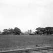
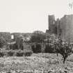
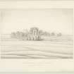
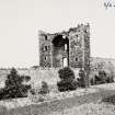
Gullane, Saltcoats Road, Saltcoats Castle


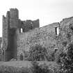
View from SW.
View in Canmore
View in Canmore

Illegible Castle, Gullane
View in Canmore
View in Canmore

Illegible Castle, Gullane
View in Canmore
View in Canmore

Illegible Castle, Gullane
View in Canmore
View in Canmore

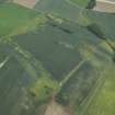
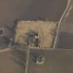
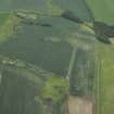
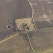
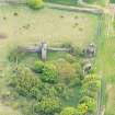
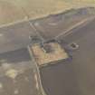
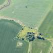
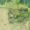
Oblique aerial view centred on the cropmarks of the rig and field boundaries with the remains of the tower-house, cottage and dovecot adjacent, taken from the NW.
View in Canmore
View in Canmore

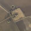
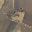
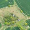
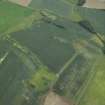
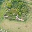
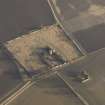
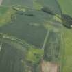
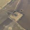
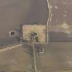
Oblique aerial view centred on the remains of the castle with the remains of the farmstead adjacent, taken from the SSW.
View in Canmore
View in Canmore

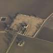
Oblique aerial view centred on the remains of the castle with the remains of the farmstead adjacent, taken from the NW.
View in Canmore
View in Canmore

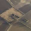
Oblique aerial view centred on the remains of the castle with the remains of the farmstead adjacent, taken from the SSE.
View in Canmore
View in Canmore

Oblique aerial view centred on the remains of the castle with the remains of the farmstead adjacent, taken from the WSW.
View in Canmore
View in Canmore

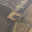
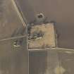
Oblique aerial view.
View in Canmore
View in Canmore

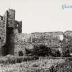
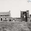
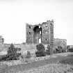
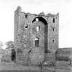
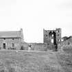
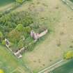
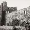
General view of Saltcoats Castle from west.
View in Canmore
View in Canmore

Illegible Castle, Gullane
View in Canmore
View in Canmore

Gullane, Saltcoats Road, Saltcoats Castle, NT48SE 7, Ordnance Survey index card, Recto
View in Canmore
View in Canmore

General view.
View in Canmore
View in Canmore

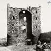
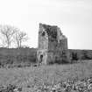
View from NW.
View in Canmore
View in Canmore

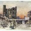
View of Saltcoats Castle, Gullane.
View in Canmore
View in Canmore

Gullane, Saltcoats Road, Saltcoats Castle, NT48SE 7, Ordnance Survey index card, page number 1, Recto
View in Canmore
View in Canmore

Oblique aerial view centred on the cropmarks of the rig and field boundaries with the remains of the tower-house, cottage and dovecot adjacent, taken from the NNW.
View in Canmore
View in Canmore

Oblique aerial view centred on the cropmarks of the rig and field boundaries with the remains of the tower-house, cottage and dovecot adjacent, taken from the NW.
View in Canmore
View in Canmore

Oblique aerial view centred on the remains of the castle with the remains of the farmstead adjacent, taken from the NW.
View in Canmore
View in Canmore

Oblique aerial view centred on the remains of the castle with the remains of the farmstead adjacent, taken from the WNW.
View in Canmore
View in Canmore

View from NW.
View in Canmore
View in Canmore

View from E.
View in Canmore
View in Canmore

Oblique aerial view.
View in Canmore
View in Canmore

Illegible Castle, Gullane
View in Canmore
View in Canmore

General view.
View in Canmore
View in Canmore

Oblique aerial view centred on the remains of the castle with the remains of the farmstead adjacent, taken from the W.
View in Canmore
View in Canmore

Oblique aerial view centred on the remains of the castle with the remains of the farmstead adjacent, taken from the WSW.
View in Canmore
View in Canmore

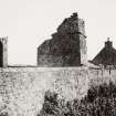
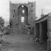
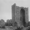
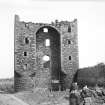
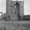
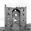
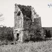
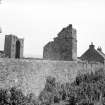
View from SE showing corbels on bartizan.
View in Canmore
View in Canmore

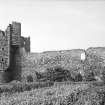
View from walled garden.
View in Canmore
View in Canmore

View from W.
View in Canmore
View in Canmore

View of Saltcoats Castle, Gullane.
View in Canmore
View in Canmore

Oblique aerial view.
View in Canmore
View in Canmore

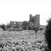
General view of Saltcoats Castle from north west.
View in Canmore
View in Canmore

Oblique aerial view centred on the cropmarks of the rig and field boundaries with the remains of the tower-house, cottage and dovecot adjacent, taken from the NNW.
View in Canmore
View in Canmore

Oblique aerial view centred on the remains of the castle with the remains of the farmstead adjacent, taken from the SE.
View in Canmore
View in Canmore

Oblique aerial view centred on the remains of the castle with the remains of the farmstead adjacent, taken from the E.
View in Canmore
View in Canmore

Oblique aerial view centred on the remains of the castle with the remains of the farmstead adjacent, taken from the W.
View in Canmore
View in Canmore

View from W.
View in Canmore
View in Canmore

General view.
View in Canmore
View in Canmore

Oblique aerial view.
View in Canmore
View in Canmore

Oblique aerial view.
View in Canmore
View in Canmore

Illegible Castle, Gullane
View in Canmore
View in Canmore

Oblique aerial view centred on the remains of the castle with the remains of the farmstead adjacent, taken from the S.
View in Canmore
View in Canmore

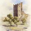
Plan.
View in Canmore
View in Canmore

View from S.
View in Canmore
View in Canmore

Oblique aerial view.
View in Canmore
View in Canmore

Illegible Castle, Gullane
View in Canmore
View in Canmore

Illegible Castle, Gullane
View in Canmore
View in Canmore

Gullane, Saltcoats Road, Saltcoats Castle, NT48SE 7, Ordnance Survey index card, page number 2, Recto
View in Canmore
View in Canmore
You may copy, display, store and make derivative works for personal use or use solely within an educational institution by staff and students, under these conditions: the ScotlandsPlaces website is attributed, there is no commercial use or sale, and no public distribution (for example, by hand, email, or web). Full licence details.
Details
Organisation: Historic Environment Scotland (HES)
Alternative name(s):
Canmore ID: 55082
Site type: Architectural Fragment (17th Century), Castle (16th Century)
County: East Lothian
Parish: Dirleton
Council: East Lothian