ScotlandsPlaces Home

Scotlands Places

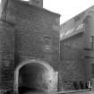
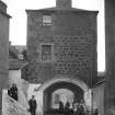
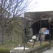
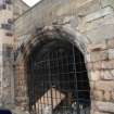
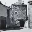
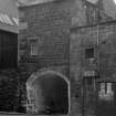
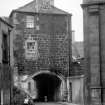
Edinburgh, Leith, Dock Street, Johnston Street, Citadel Arch


  • Edinburgh, Leith, Dock Street, Citadel. General view of the archway.  Copyright RCAHMS
  • Edinburgh, Leith, Dock Street, Citadel. General view of the arch.  Copyright RCAHMS
  • Ordnance Survey Map of Edinburgh. Coloured 1st edition 'Edinburgh and its Environs', Sheet 12. Includes Leith Fort, Leith Citadel, part of Leith Docks, North Junction Street. Ordnance Survey. Historical Maps. Date 30/9/1853 Copyright RCAHMS
  • Edinburgh, Dock Street, Citadel. General view with children. Francis M Chrystal Date 1900 Copyright RCAHMS
  • The Citadel Arch, Dock Street, Edinburgh with people. Since demolished. Francis M Chrystal Date 1912 Copyright RCAHMS


You may copy, display, store and make derivative works for personal use or use solely within an educational institution by staff and students, under these conditions: the ScotlandsPlaces website is attributed, there is no commercial use or sale, and no public distribution (for example, by hand, email, or web). Full licence details.

Edinburgh, Leith, Dock Street, Citadel. General view of the archway. Copyright RCAHMS
Item SC610477

Organisation

The Royal Commission on the Ancient and Historical Monuments of Scotland

Alternative Name(s)

CITADEL OF LEITH; LEITH CITADEL; CROMWELLIAN FORT

Canmore ID

51917

Site Type

ARTILLERY FORTIFICATION

County

MIDLOTHIAN

Parish

EDINBURGH (EDINBURGH, CITY OF)

Council

EDINBURGH, CITY OF

NGR

NT 26782 76615

Latitude, Longitude

55.976915N, 3.174845W

Images

Archaeological Notes
NT27NE 10 26782 76615

(NT 2678 7661) Citadel Port (NR)
Citadel (NR) (remains of)
OS 6" map, Edinburghshire, 1st ed., (1853).

For discovery or discoveries of bronze axes (possibly a hoard) near the citadel, see NT27NE 16.

For indeterminate 'Roman' remains (found 1825, 'in the neighbourhood of the Citadel'), see NT27NE 23.

For 2004 discovery of part of the course of the Leith Citadel ditch and revetment wall (at NT 267 765), see NT27NE 1555.

After the battle of Dunbar in 1650, Cromwell took possession of Leith and introduced a number of English settlers. For their protection, General Monk erected a citadel at the NW corner of North Leith, partly on the parish burial ground. (see NT27NE 9).
According to Maitland (1753) it was pentagonal in shape with a bastion at each corner and one gateway, facing E. Arnot (1788) writing in 1779, notes that apart from "a strong gate with portcullices" most of the Citadel had already been demolished. The substructure of this gate still survives, giving access from Dock Street to Johnstone Street. It consists of a vaulted pend, with an arched gateway at either end. The gateway to the NE has provision for a double door, no doubt the "portcullices" mentioned by Arnot. The superstructure has been rebuilt as a house of two storeys.
W Maitland 1753; H Arnot 1788; RCAHMS 1951.

No change from previous information.
Visited by OS (B S) 27 November 1975.

The parapet is a conjectured reconstruction by Edinburgh City Architect's Department, 1964.
J Gifford, C McWilliam and D Walker 1984.

NT 2674 7654 The projected route of the Leith Citadel ditch and revetment wall (NT27NE 10) was found during an evaluation between November 2004 and January 2005. Evidence of later stone robbing from the revetment wall was also recorded. In addition, buried garden soils possibly dating to the 17th century were seen to exist in the NE part of the site. Earlier coastal deposits also survived on site. No evidence was encountered of structures within the Citadel.
Archive to be deposited in NMRS.
Sponsor: Hart Estates Ltd.
E Hindmarch 2005.

Architectural Notes
NT27NE 10 26782 76615

Also known as Cromwell Barracks, built about 1656 by General Monk.
Demolished c.1948 to make way for industrial development.

Historical file.
"The Citadel Leith"
- 1 Drawing by Rollo.
- 1 News cutting.

In the National Library of Scotland, Vol.II., No 37, of Water Colour Sketches by Thomas Brown, Advocate, is a view in this Street. It seems to show the Citadel Port. Reference "Adv. MSS. 34.8.1-3"
See under "Water colour Sketches, series of, by Thomas Brown, Advocate".

Edinburgh, Leith, Citadel Feuing.
James Gillespie Graham.
Leith, lands at the Citadel. Feuing plan, 1807.
(Edinburgh Evening Courant, Feb 14, 1807).

Sources: Dean of Guild 2.6.1814
Pet. John Martin, Merchant in Queensferry.
Corner tenement fronting the Citadel of Leith, near to the West end of therof - - precise location unknown at time of upgrade, 8.2.2000
Minor alterations - door

Related Material Information - Bibliographical References


Arnot, H (1788) The history of Edinburgh from the earliest accounts to the present time..., Edinburgh. Held at RCAHMS: D.8.3.ARN.R
Brown and Stronach, G and S (2002) 'Dock Street, Leith, City of Edinburgh (City parish of Edinburgh), Cromwellian citadel',
Cruft, C (1975) Edinburgh old and new, Wakefield. Held at RCAHMS: D.8.31.CRU
Gifford, McWilliam and Walker, J, C and D (1984) Edinburgh, Harmondsworth. Held at RCAHMS: Quick
Hindmarch, E (2005) 'Coburg Street, Leith (City parish of Edinburgh), citadel'
Irons, J C (1901) Leith and its antiquities from the earliest times to the close of the nineteenth century: with numerous illustrations, biographical sketches and portraits of the Members of Parliament, Provosts and distinguished ministers &c. &c: also an appendix of charters, deeds and documents relating to the burgh, [s.l.] (Edinburgh). Held at RCAHMS: D.8.41.LEI
Maitland, W (1753) The history of Edinburgh from its foundation to the present time, containing a faithul relation of the publick transactions of the citizens; accounts of several parishes; its governments, civil, ecclesiastical, and military; incorporations of trades and manufactures; courts of justice; state of learning; charitable foundations &c....in nine books, Edinburgh. Held at RCAHMS: D.8.3.MAI.R
Pryde, G S (1965) The burghs of Scotland: a critical list, London. Held at RCAHMS: C.3.3.PRY
RCAHMS (1951) The Royal Commission on the Ancient Monuments of Scotland. An inventory of the ancient and historical monuments of the city of Edinburgh with the thirteenth report of the Commission, Edinburgh. Held at RCAHMS: A.1.1.INV/13
Roy, M (2002) 'The excavation of the south-western bastion of Cromwell's citadel on the South Inch, Perth', Perth.
Tait, A A (1965) 'The protectorate citadels of Scotland',

Related Material Information - Description of Collections


Digital Images

DP049352 (1943)
Edinburgh, Leith, Dock Street, Citadel. Plan and elevation of the Citadel gateway and barrel vault. Insc: 'Cromwell's Citadel, Leith' Dyeline copy RCAHMS
DP097474 (30/9/1853)
Ordnance Survey Map of Edinburgh. Coloured 1st edition 'Edinburgh and its Environs', Sheet 12. Includes Leith Fort, Leith Citadel, part of Leith Docks, North Junction Street. RCAHMS collection Ordnance Survey. Historical Maps.

Manuscripts

MS5266/4 (1/2002)
(Dock Street, Leith) Survey Points (1p) Context Sheets - Contexts 15-31 (17pp) Photo Register No.3 (1p) Drawing Register (1p) Photo Register No.2 (1p) Context Register - Contexts 15-31) (1p) Trench Record Sheets 3,4,6,5 (4pp) Headland Archaeology Ltd collection Headland Archaeology Ltd
MS5266/3 (1/2002)
(Dock Street, Leith) Sample Register (1p) Context Register - Contexts 1-14) (1p) Context Sheets - Contexts 1-14 (14pp) Sketch diagram Trench 2 (1p) Photo Register No. 1.(1p) Headland Archaeology Ltd collection Headland Archaeology Ltd
MS5266/2 (1/2002)
Results of an Archaeological Investigation at Dock Street, Leith: Phase 2 - (Simon Stronach),Headland Archaeology Ltd - for Client: Gregor Shore plc. August 2002 Headland Archaeology Ltd collection Headland Archaeology Ltd
MS5266/1 (1/2002)
Results of an Archaeological Investigation at Dock Street, Leith - Graeme Brown, Headland Archaeology Ltd - for Client: Gregor Shore plc. January 2002. Headland Archaeology Ltd collection Headland Archaeology Ltd

Photographs

ED2978 (1950)
Edinburgh, Leith, Dock Street, Citadel. General view of the archway. RCAHMS
ED2977 (1950)
Edinburgh, Leith, Dock Street, Citadel. General view of the arch. RCAHMS
ED3912
Edinburgh, Leith, Dock Street, Citadel. General view of the arch. RCAHMS
ED346/2PO
Edinburgh, Leith, Dock Street, Citadel. General view looking through the Citadel arch to Johnston Street with children and adults on the steps and on the pavement. RCAHMS
ED3911
Edinburgh, Leith, Citadel. General view with horse visible through archway. RCAHMS
ED14827 (1975)
Edinburgh, Leith Citadel. General view of arch and steps after demolision of the rest of the building. RCAHMS
G89925CS (1970)
View of the gates of the old Citidel, Dock Street, now demolished. collection William McKelvie
G89633CS (1970)
View of the entrance gate to the old Citidal, Dock Street. Leith. RCAHMS collection William McKelvie
G89632S (1970)
Photographic copy of an early map showing detail of the Citidal, Dock Street, Leith. RCAHMS collection William McKelvie
ED7632 (1900)
Edinburgh, Dock Street, Citadel. General view with children. RCAHMS collection Francis M Chrystal
ED7631 (1912)
Edinburgh, Dock Street, Citadel. General view with people. RCAHMS collection Francis M Chrystal
BP174/3 (1/2002)
Photographs from Dock Street, Leith 2 Facing NE Sondage down face of wall 28 3 Facing NE Sondage down face of wall 28 4 Facing W E facing section trench 3, cobbling 24 7 Facing N Cobbling 24 10 Facing SE Wall foundations 27 & 29 13 Facing NE Wall 28 ashlar face Headland Archaeology Ltd collection Headland Archaeology Ltd
BP174/2 (1/2002)
Photographs from Dock Street, Leith 2 Facing NW Trench 3 general 4 Facing W. Modern wall 15, trench 3 6 Facing E West facing section trench 3 (partial section through ditch) 7 Facing S NE facing section trench 4 (SE end) 10 Facing SE Trench 4 general (SE end) 13 Facing W Trench 4 sondage under cellar 16 Facing NW Citadel ditch wall foundation 28 in background, sondage following mortar spread in citadel ditch 18 Facing NE Citadel ditch wall foundation 28 & cut 17 in section 20 Facing SW Trench 5 general 22 Facing NE Trench 6 general 24 Facing SW Trench 6 general 26 Facing W Trench 3 E facing section of machine sondage 29 Facing E Trench 3 W facing section of machine sondage Headland Archaeology Ltd collection Headland Archaeology Ltd
BP174/1 (1/2002)
Photographs from Dock Street, Leith 1 & 2 Facing NW Western end of Trench 1 See also BS 141/1 3 Facing E. Trench 1 showing foundation See also BS 141/2 4 Facing E. Trench 1 showing foundation 5 Facing NE. Possibly omitted from Photo Register -(?) Showing depth of trench (?) 6 & 7 Facing NE. Walls11 &12 plus lime mortar spread, Trench 2 (?). See also BS 141/3 8 Facing NE. Walls 8 & 9 Trench 2 (?) 9 Facing NE. Wall 7 Trench 2 (?) Headland Archaeology Ltd collection Headland Archaeology Ltd
BS141CS (1/2002)
Colour Slides from Dock Street, Leith 1/1 Facing NW. Western end of Trench 1. (Phase 1, January 2002) See also BP 141/1 1/2 Facing E. Trench 1 showing foundation. (Phase 1, January 2002) See also BP 141/3 1/3 Facing NE. Trench 2. Walls 11&12 plus lime mortar spread. (Phase 1, January 2002). See also BP 141/6 Remaining slides are all from Phase 2, August 2002. 2.3 Facing NW. Trench 3 general (Remaining slides all Phase 2, August 2002) 2.5 Facing W. Modern wall 15, trench 3 2.6 Facing E. Modern wall 15, trench 3 2.8 Facing NW. Modern wall 15, trench 3 2.9 Facing NW. Modern wall 15, trench 3 2.12 Facing E. West facing section, trench 3 2.15 Facing S. NE facing section, trench 4 (SE end) 2.18 Facing SE. Trench 4 general (SE end) 2.21 Facing W. Trench 4 - sondage under cellar 2.23 Facing NW. Citadel ditch wall foundation 28 2.24 Facing NE. Citadel ditch wall foundation 28 & cut 17 2.26 Facing E. Trench 5 general 2.28 Facing E. Trench 6 general 2.30 Facing W. Trench 6 general 2.32 Facing W. Trench 3. E facing section of machine sondage 2.35 Facing E. Trench 3. W facing section of machine sondage 3.3 Facing NE. Sondage down face of wall 28 3.6 Facing W. E facing section trench 3, cobbling 24 3.7 Facing N. Cobbling 24 3.8 Facing N. Cobbling 24 3.11 Facing SE. Wall foundations 27 & 29 3.12 Facing NE. Wall 28 ashlar face Headland Archaeology Ltd collection Headland Archaeology Ltd

Print Room

E83486NC (23/10/1948)
Edinburgh, Leith, Leith Citadel. Image and caption of building at Leith Citadel. Titled: 'A seventeenth century building at Leith Citadel, which is now being demolished for industrial development. This building is part of the Citadel, known as Cromwell's Barracks, and was built about 1656 by General Monk, the City of Edinburgh contributing 5000 pounds'. Evening Dispatch

Prints And Drawings

EDD131/1 (1943)
Edinburgh, Leith, Dock Street, Citadel. Plan and elevation of the Citadel gateway and barrel vault. Insc: 'Cromwell's Citadel, Leith' Dyeline copy RCAHMS
DC6512
Edinburgh, Citadel Street, Leith Citadel. Plan of citadel superimposed upon modern map. Unsigned. RCAHMS
DC6511
Edinburgh, Citadel Street, Leith Citadel. Plan of Citadel existing. Titled: 'No.12' Unsigned. RCAHMS
DC6510
Edinburgh, Citadel Street, Leith Citadel. Plan of Mr Davidson property of Citadel. Titled: 'Plan of Property at Citadel belonging to Mr Davidson'. Unsigned. RCAHMS
DC6509
Edinburgh, Citadel Street, Leith Citadel. Plan of ground at Citadel Green. Titled: 'Plan of Citadel Green, Leith'. Unsigned. RCAHMS
BD149 (4/2002)
BD 149/1 Plan 1 - Trench 1. 1:50 16.1.02 BD 149/2 Plan 2 - Trench 2. 1:50 BD 149/3 Trench 3 - NW-facing Section of Wall foundation & overlying levelling deposit [18] BD 149/4 Trench 3 - continuation of BD 149/3: NW-facing Section of Wall foundation & overlying levelling deposit [18] BD 149/5 Untitled (but shows Section of Hardcore over [22], [23], [24] BD 149/6? (This plan appears to relate to different project) Headland Archaeology Ltd collection Headland Archaeology Ltd

Scanned Images

SC610477
Edinburgh, Leith, Dock Street, Citadel. General view of the archway. RCAHMS
SC610475
Edinburgh, Leith, Dock Street, Citadel. General view of the arch. RCAHMS
SC1098950 (1900)
Edinburgh, Dock Street, Citadel. General view with children. RCAHMS collection Francis M Chrystal
SC621194 (1912)
The Citadel Arch, Dock Street, Edinburgh with people. Since demolished. RCAHMS collection Francis M Chrystal

Related OS 6-inch maps