
Carlowrie


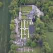
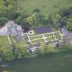
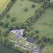
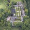
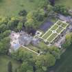
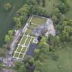
Oblique aerial view of Carlowrie Country House, walled garden, main stable block and Westfield Steading, looking ENE.
View in Canmore
View in Canmore

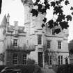
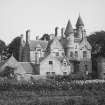
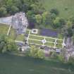
View from SE.
View in Canmore
View in Canmore

Oblique aerial view of Carlowrie Country House, walled garden, main stable block and Westfield Steading, looking SSE.
View in Canmore
View in Canmore

General oblique aerial view of the new Forth crossing works site centred on the M8 junction, taken from the W.
View in Canmore
View in Canmore

Oblique aerial view of Carlowrie Country House, walled garden, main stable block and Westfield Steading, looking N.
View in Canmore
View in Canmore

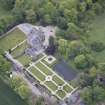
Oblique aerial view of Carlowrie Country House, walled garden, main stable block and Westfield Steading, looking ESE.
View in Canmore
View in Canmore

View from SW.
View in Canmore
View in Canmore

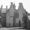
View from NW. View of rear.
View in Canmore
View in Canmore

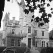
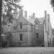
View of Carlowrie House from SE.
View in Canmore
View in Canmore

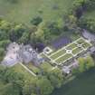
Oblique aerial view of Carlowrie Country House, walled garden, main stable block and Westfield Steading, looking SE.
View in Canmore
View in Canmore

Oblique aerial view of Carlowrie Country House, walled garden, main stable block and Westfield Steading, looking NNW.
View in Canmore
View in Canmore

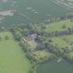
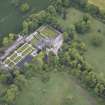
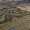
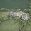
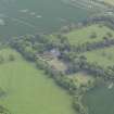
General oblique aerial view of Carlowrie Country House, looking NNE.
View in Canmore
View in Canmore

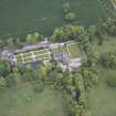
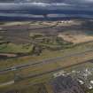
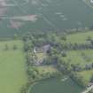
General oblique aerial view of Carlowrie Country House with the runway in the foreground, looking NNE.
View in Canmore
View in Canmore

General oblique aerial view of Carlowrie Country House with the runway in the foreground and the Bridges in the distance, looking N.
View in Canmore
View in Canmore

Oblique aerial view of Carlowrie Country House, walled garden, main stable block and Westfield Steading, looking SW.
View in Canmore
View in Canmore

Oblique aerial view of Carlowrie Country House, walled garden, stable block and Westfield Steading, looking SSW.
View in Canmore
View in Canmore

Oblique aerial view of Carlowrie Country House, walled garden, main stable block and Westfield Steading, looking S.
View in Canmore
View in Canmore

Oblique aerial view of Carlowrie Country House, walled garden, main stable block and Westfield Steading, looking NW.
View in Canmore
View in Canmore

View from NE.
View in Canmore
View in Canmore

Oblique aerial view of Carlowrie Country House, walled garden, main stable block and Westfield Steading, looking E.
View in Canmore
View in Canmore

Carlowrie, NT17SW 52, Ordnance Survey index card, Recto
View in Canmore
View in Canmore

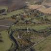
General oblique aerial view of Carlowrie Hous estate centred on the house, taken from the WNW.
View in Canmore
View in Canmore

General oblique aerial view of the new Forth crossing works site centred on the M8 junction, taken from the WSW.
View in Canmore
View in Canmore

Oblique aerial view of Carlowrie Country House, walled garden, main stable block and Westfield Steading, looking NE.
View in Canmore
View in Canmore
You may copy, display, store and make derivative works for personal use or use solely within an educational institution by staff and students, under these conditions: the ScotlandsPlaces website is attributed, there is no commercial use or sale, and no public distribution (for example, by hand, email, or web). Full licence details.
Details
Organisation: Historic Environment Scotland (HES)
Alternative name(s): Carlowrie Castle
Canmore ID: 50766
Site type: Country House (19th Century)
County: West Lothian
Parish: Kirkliston (city Of Edinburgh/w Lothian)
Council: Edinburgh, City Of