
Dun Canna


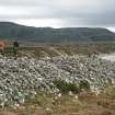
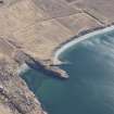
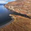
Copy of colour slide showing view of promontory fort, Dun Canna nr Ullapool, Highland - defence of main (landward) enclosure from seaward side
NMRS Survey of Private Collection
Digital Image only
View in Canmore
View in Canmore

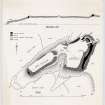
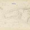
Publication drawing; plan and section of Dun Canna fort.
View in Canmore
View in Canmore

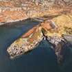
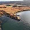
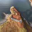
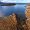
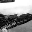
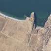
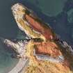
General oblique aerial view with Dun Canna fort and the adjacent fish trap in the foreground and Strath Canaird and the Rhidorroch Forest beyond, looking W.
View in Canmore
View in Canmore

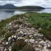
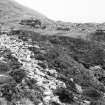
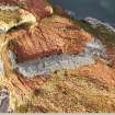
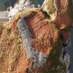
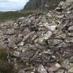
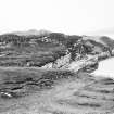
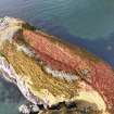
General view of walling on the SE side of the lower fort.
View in Canmore
View in Canmore


Dun Canna, NC10SW 1, Ordnance Survey index card, page number 2, Verso
View in Canmore
View in Canmore

Dun Canna, NC10SW 1, Ordnance Survey index card, Recto
View in Canmore
View in Canmore

Oblique aerial view
View in Canmore
View in Canmore

Dun Canna, NC10SW 1, Ordnance Survey index card, Recto
View in Canmore
View in Canmore

Oblique aerial view
View in Canmore
View in Canmore

Oblique aerial view
View in Canmore
View in Canmore

Copy of colour slide showing view of promontory fort, Dun Canna nr Ullapool, Highland - main (landward) rampart from seaward side
NMRS Survey of Private Collection
Digital Image only
View in Canmore
View in Canmore

Copy of colour slide showing view of promontory fort, Dun Canna nr Ullapool, Highland - main (landward) defence from seaward side
NMRS Survey of Private Collection
Digital Image only
View in Canmore
View in Canmore

Dun Canna, NC10SW 1, Ordnance Survey index card, page number 1, Recto
View in Canmore
View in Canmore

Dun Canna, NC10SW 1, Ordnance Survey index card, Recto
View in Canmore
View in Canmore

Oblique aerial view
View in Canmore
View in Canmore

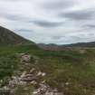
General view along the SE side of the lower enclosure towards the upper enclosure.
View in Canmore
View in Canmore

Survey drawing; Dun Canna fort.
View in Canmore
View in Canmore

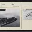
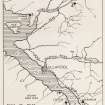
Publication drawing: Prehistoric Monuments near Ullapool: map showing sites.
View in Canmore
View in Canmore

Oblique aerial view
View in Canmore
View in Canmore

Dun Canna, NC10SW 1, Ordnance Survey index card, page number 3, Recto
View in Canmore
View in Canmore

Oblique aerial view
View in Canmore
View in Canmore

Oblique aerial view
View in Canmore
View in Canmore

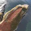
General oblique aerial view of Dun Canna fort and the adjacent fish trap, looking SW.
View in Canmore
View in Canmore

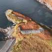
Oblique aerial view of Dun Canna fort and the adjacent fish trap, looking SE.
View in Canmore
View in Canmore

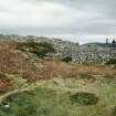
View down onto Dun Canna fort from higher ground.
View in Canmore
View in Canmore

Exposed outer wall face on the E wall of the E enclosure.
View in Canmore
View in Canmore

Oblique aerial view
View in Canmore
View in Canmore

Oblique aerial view
View in Canmore
View in Canmore

Oblique aerial view
View in Canmore
View in Canmore

Oblique aerial view of Dun Canna fort and the adjacent fish trap, looking W.
View in Canmore
View in Canmore

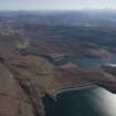
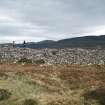
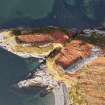
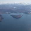
General oblique aerial view with Isle Martin and Loch Kanaird in the middle distance and Loch Broom and Ullapool beyond, looking SE.
View in Canmore
View in Canmore


Dun Canna, NC10SW 1, Ordnance Survey index card, Recto
View in Canmore
View in Canmore

Oblique aerial view
View in Canmore
View in Canmore

Oblique aerial view
View in Canmore
View in Canmore

Oblique aerial view
View in Canmore
View in Canmore


You may copy, display, store and make derivative works for personal use or use solely within an educational institution by staff and students, under these conditions: the ScotlandsPlaces website is attributed, there is no commercial use or sale, and no public distribution (for example, by hand, email, or web). Full licence details.
Details
Organisation: Historic Environment Scotland (HES)
Alternative name(s):
Canmore ID: 4530
Site type: Fort (prehistoric)
County: Ross And Cromarty
Parish: Lochbroom
Council: Highland