
Clachtoll


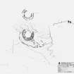
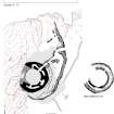
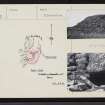
Clachtoll Broch, measured survey drawing including ground plan & section.
View in Canmore
View in Canmore

Clachtoll Broch, ground plan & section.
View in Canmore
View in Canmore

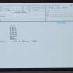
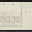
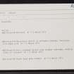
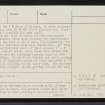
Clachtoll, NC02NW 2, Ordnance Survey index card, Recto
View in Canmore
View in Canmore

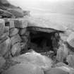
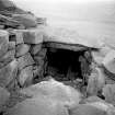
Clachtoll broch. End of stair emerging at level of first gallery.
View in Canmore
View in Canmore

Clachtoll broch. End of stair emerging at level of first gallery.
View in Canmore
View in Canmore

Clachtoll, NC02NW 2, Ordnance Survey index card, Recto
View in Canmore
View in Canmore

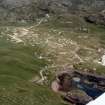
Oblique aerial view of holiday site at Bay of Clachtoll, Assynt, Sutherland, looking E.
View in Canmore
View in Canmore

Clachtoll broch
View from S showing outer wall joining up with broch face
View in Canmore
View in Canmore

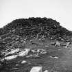
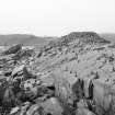
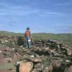
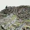
Clachtoll broch
General view.
View in Canmore
View in Canmore

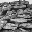
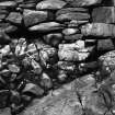
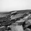
Clachtoll broch
Footings of wall founded on natural rock.
View in Canmore
View in Canmore

Clachtoll, NC02NW 2, Ordnance Survey index card, page number 1, Recto
View in Canmore
View in Canmore

Clachtoll, NC02NW 2, Ordnance Survey index card, page number 4, Verso
View in Canmore
View in Canmore

Clachtoll, NC02NW 2, Ordnance Survey index card, Recto
View in Canmore
View in Canmore

Copy of colour slide showing detail of Broch "An Dun" Stoer, Sutherland -interior
NMRS Survey of Private Collection
Digital Image only
View in Canmore
View in Canmore

Clachtoll broch
Footings of wall founded on natural rock.
View in Canmore
View in Canmore

Clachtoll broch
View towards entrance in outer wall leading to the broch entrance.
View in Canmore
View in Canmore

Copy of colour slide showing detail of Broch "An Dun" Stoer, Sutherland - rear view
NMRS Survey of Private Collection
Digital Image only
View in Canmore
View in Canmore

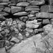
Clachtoll broch
Inner face showing angle of passage opening from chamber over entrance.
View in Canmore
View in Canmore

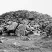
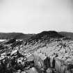
Clachtoll broch
General view.
View in Canmore
View in Canmore

Clachtoll, NC02NW 2, Ordnance Survey index card, page number 3, Recto
View in Canmore
View in Canmore

Clachtoll, NC02NW 2, Ordnance Survey index card, Recto
View in Canmore
View in Canmore

Clachtoll broch. End of stair emerging at level of first gallery.
View in Canmore
View in Canmore

Clachtoll, NC02NW 2, Ordnance Survey index card, Recto
View in Canmore
View in Canmore

Copy of colour slide showing detail of Broch "An Dun" Stoer, Sutherland - front view showing entrance to broch
NMRS Survey of Private Collection
Digital Image only
View in Canmore
View in Canmore

Clachtoll, NC02NW 2, Ordnance Survey index card, page number 2, Verso
View in Canmore
View in Canmore
You may copy, display, store and make derivative works for personal use or use solely within an educational institution by staff and students, under these conditions: the ScotlandsPlaces website is attributed, there is no commercial use or sale, and no public distribution (for example, by hand, email, or web). Full licence details.
Details
Organisation: Historic Environment Scotland (HES)
Alternative name(s):
Canmore ID: 4499
Site type: Broch (iron Age)
County: Sutherland
Parish: Assynt
Council: Highland