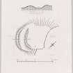
Dunduff


Details
Organisation: Historic Environment Scotland (HES)
Alternative name(s):
Canmore ID: 40936
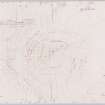
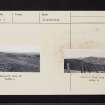
Site type: Fort (iron Age)
County: Ayrshire
Parish: Maybole
Council: South Ayrshire

Organisation: Historic Environment Scotland (HES)
Alternative name(s):
Canmore ID: 40936
Site type: Fort (iron Age)
County: Ayrshire
Parish: Maybole
Council: South Ayrshire