
St Kilda, Hirta, Mullach Mor, Radar Station


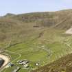
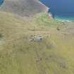
Hirta, Village Bay. General view from SE showing the Street, crofts and head dyke, and including the Ministry of Defence Establishment and the radar station on Mullach Mor.
View in Canmore
View in Canmore

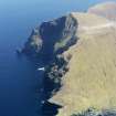
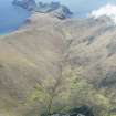
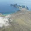
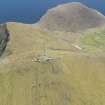
General oblique aerial view of St Kilda, centred on Mullach Sgar, taken from the S.
View in Canmore
View in Canmore

General oblique aerial view of St Kilda, centred on the island of Hirta, taken from the NW.
View in Canmore
View in Canmore

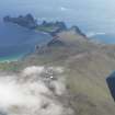
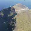
General oblique aerial view of St Kilda, centred on Mullach Mor Radar Station, taken from the NW.
View in Canmore
View in Canmore

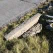
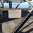
Detail of bridge abutment, Mullach Geal, St Kilda, showing graffiti.
View in Canmore
View in Canmore

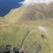
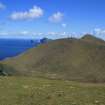
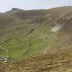
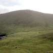
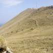
View E across Gleann Mor to Mullach Mor
View in Canmore
View in Canmore

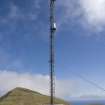
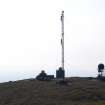
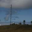
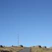
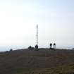
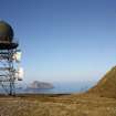
Mullach Mor, Radar Station. Tall mast viewed from SW.
View in Canmore
View in Canmore

General oblique aerial view of St Kilda, centred on Gleann Mor and the island of Dun, taken from the N.
View in Canmore
View in Canmore

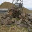
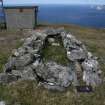
Cleit 654 and Radar Station (292457)
View in Canmore
View in Canmore

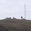
Mullach Mor, Radar Station. General view from Conachair to E.
View in Canmore
View in Canmore

Mullach Mor, Radar Station. General view from SSE.
View in Canmore
View in Canmore

General oblique aerial view of St Kilda, centred on Mullach Mor Radar Station, taken from the NW.
View in Canmore
View in Canmore

View from E
View in Canmore
View in Canmore

Hirta, Village Bay. General view from SE showing the Street, crofts and head dyke, and including the Ministry of Defence Establishment and the radar station on Mullach Mor.
View in Canmore
View in Canmore

General oblique aerial view of St Kilda, centred on Mullach Sgar and the island of Dun, taken from the N.
View in Canmore
View in Canmore

General oblique aerial view of St Kilda, centred on Mullach Mor Radar Station, taken from the NNW.
View in Canmore
View in Canmore

General oblique aerial view of St Kilda, centred on Mullach Mor Radar Station, taken from the WNW.
View in Canmore
View in Canmore

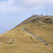
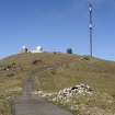
General view of Mullach Mor, St Kilda, showing cleitean and masts, looking N.
View in Canmore
View in Canmore

Detail of plate on radar tower, Mullach Mor, St Kilda.
View in Canmore
View in Canmore

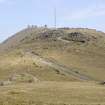
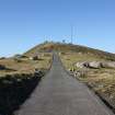
General view of the road to Mullach Mor, St Kilda, with the radars on Mullach Sgar in the distance.
View in Canmore
View in Canmore

View E across Gleann Mor to Mullach Mor
View in Canmore
View in Canmore

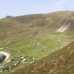
Mullach Mor, Radar Station. Distant view from the SW across the head of Gleann Mor with cleits in the foreground.
View in Canmore
View in Canmore

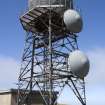
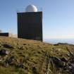
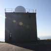
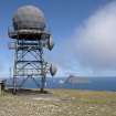
Mullach Mor, Radar Station. Mast with dome viewed from SE.
View in Canmore
View in Canmore

General oblique aerial view of St Kilda, centred on Mullach Sgar and the island of Dun, taken from the N.
View in Canmore
View in Canmore

Cleit 668 and Radar Station (292457)
View in Canmore
View in Canmore

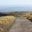
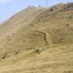
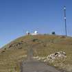
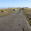
Mullach Mor, Radar Station. Road to radar station viewed from S, with cleits in the foreground.
View in Canmore
View in Canmore

Mullach Mor, Radar Station. Road to radar station viewed from S, with cleits in the foreground.
View in Canmore
View in Canmore

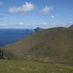
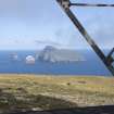
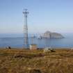
Mullach Mor, Radar Station. View across to Boreray, Stac Lee and Stac An Armin.
View in Canmore
View in Canmore

Mullach Mor, Radar Station. Detail of the tensioned mast supports with Oiseval and Levenish in the distance.
View in Canmore
View in Canmore

Mullach Mor, Radar Station. Road to radar station viewed from S.
View in Canmore
View in Canmore

Mullach Mor, Radar Station. Road to radar station viewed from S.
View in Canmore
View in Canmore

Detail of bridge abutment, Mullach Geal, St Kilda, showing graffiti.
View in Canmore
View in Canmore

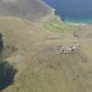
General view of buildings at Mullach Mor Radar Station, St Kilda.
View in Canmore
View in Canmore

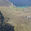
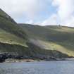
St Kilda, Gleann Mor. General view of the east side.
View in Canmore
View in Canmore

General view N towards Mullach Mor
View in Canmore
View in Canmore

Mullach Mor, Radar Station. Distant view from Conachair to E.
View in Canmore
View in Canmore

Hirta, Village Bay. General view from SE showing the Street, crofts and head dyke, and including the Ministry of Defence Establishment and the radar station on Mullach Mor.
View in Canmore
View in Canmore

General oblique aerial view of St Kilda, centred on the island of Hirta, taken from the NW.
View in Canmore
View in Canmore

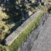
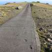
Detail of concrete road on Mullach Geal, St Kilda, showing footprints.
View in Canmore
View in Canmore

Detail of concrete road on Mullach Geal, St Kilda, showing footprints.
View in Canmore
View in Canmore

General view of the radar tower at Mullach Mor, St Kilda, with Conachair on the right and Boreray in the distance.
View in Canmore
View in Canmore

General view of mast at Mullach Mor, St Kilda, with Boreray in the distance.
View in Canmore
View in Canmore

General view of buildings at Mullach Mor Radar Station, St Kilda.
View in Canmore
View in Canmore

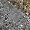
Detail of concrete patch and hand print in road to Mullach Mor, St Kilda.
View in Canmore
View in Canmore

Mullach Mor, Radar Station. Distant view from the SW across the head of Gleann Mor with cleits in the middle distance.
View in Canmore
View in Canmore

Mullach Mor, Radar Station. Mast with dome viewed from S with Boreray in the distance.
View in Canmore
View in Canmore

General view of the road to Mullach Mor, showing cleitean and masts, looking N.
View in Canmore
View in Canmore

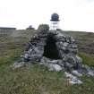
Cleit 665 with Radar Station in background (292457)
View in Canmore
View in Canmore

You may copy, display, store and make derivative works for personal use or use solely within an educational institution by staff and students, under these conditions: the ScotlandsPlaces website is attributed, there is no commercial use or sale, and no public distribution (for example, by hand, email, or web). Full licence details.
Details
Organisation: Historic Environment Scotland (HES)
Alternative name(s):
Canmore ID: 292457
Site type: Radar Station (20th Century)
County: Inverness-shire
Parish: Harris
Council: Western Isles