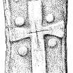
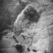
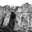
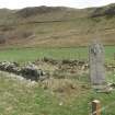
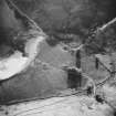
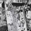
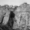
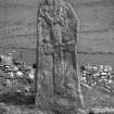
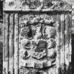
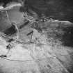
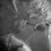
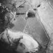
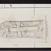
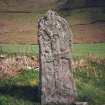
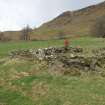
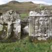
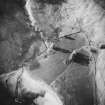
Camas Nan Geall, Cladh Chiarain
Organisation The Royal Commission on the Ancient and Historical Monuments of Scotland
Alternative Name(s) ARDNAMURCHAN, CAMAS NAN GEALL; LOCH SUNART; CLADH CHIARAN
Canmore ID 22350
Site Type BURIAL GROUND, CROSS INCISED STONE, GRAVE SLAB(S), STANDING STONE
County ARGYLL
Parish ARDNAMURCHAN
Council HIGHLAND
NGR NM 56039 61858
Latitude, Longitude 56.684579N, 5.985098W
Images 5
Alternative Name(s) ARDNAMURCHAN, CAMAS NAN GEALL; LOCH SUNART; CLADH CHIARAN
Canmore ID 22350
Site Type BURIAL GROUND, CROSS INCISED STONE, GRAVE SLAB(S), STANDING STONE
County ARGYLL
Parish ARDNAMURCHAN
Council HIGHLAND
NGR NM 56039 61858
Latitude, Longitude 56.684579N, 5.985098W
Images 5
Summary Notes
Camas nan Geall (bay of strangers) Ardnamurchan¿s long history of settlement can be traced through the rich layers of material evidence scattered about this unexpectedly fertile crescent in the lee of volcanic Ben Hiant (Beinn Shianta - holy mountain). Vestigial chambered cairn, parts of chamber evident but most cairn stones looted for later buildings. To the south, two graveyards, most notable the burial ground of the Campbells of Ardslignish, 18th century, with limemortared rubble masonry enclosing, among other fragments, two fine ogee-pedimented headstones carved with cherubs¿ heads. One stone depicts the Crucifixion in high relief, the other, dated 1737, a Campbell coat of arms flanked by reeded pilasters. Standing stone to south-west, one face carved with Early Christian motifs: a dog between two crosses. To the south (near Ardslignish farmhouse), old burying ground, now little more than a turf-walled enclosure. On the western headland, fragments of an Iron Age promontory fort. Around the bay, the evolution of the local dwelling types that superseded creel houses is well represented. Structures surviving in ruin include the round-angled, chimneyless stone house which had cruck couples and thatch, and the post-clearance `improved¿ shepherd¿s cottage, with gables and slated roof. Sheep fanks built of stones from abandoned dwellings symbolise 19th century changes in land use and settlement.
Taken from "Western Seaboard: An Illustrated Architectural Guide", by Mary Miers, 2008. Published by the Rutland Press http://www.rias.org.uk
Archaeological Notes
NM56SE 2 56039 61856.
(NM 5605 6184) Old Burial Ground (NAT)
OS 6"map, Argyllshire, 2nd ed., (1902)
An ancient burial ground called Cladh Chiarain, after St Ciaran mac an t-Saeir (d. 549) who is said to be buried there. It is a small enclosure and contains a cross-inscribed stone.
M E M Donaldson 1923; W J Watson 1926.
Cladh Chiarian, a disused burial ground, marked by a turf-covered wall, overlaid by modern fence. Within it a walled enclosure has been built, probably as a private burial plot. The cross-inscribed stone and a few 18th-century grave-slabs are within the graveyard.
Surveyed at 1:2500.
Visited by OS (N K B) 8 June 1970.
(NM 5605 6184) Cladh Chiarain (NR)
(NM 5603 6184) Cross Slab (NR)
OS 1:10,000 map, (1974)
Burial-ground, Camas nan Geall: The remains of this burial-ground comprise a ruinous outer enclosure-wall and an inner structure of lime-mortared rubble masonry. This measures 8.2m from NE to SW 5.9m transversely within walls 0.5m in thickness which stand to a uniform height of 0.9m; the entrance is in the NE wall, This structure may be ascribed to the 18th century and it is possible that the burial-ground as a whole was created at that period for the Roman Catholic members of the family of Campbell of Ardslignish. (Three 18th-century funerary monuments within the burial ground are described by the RCAHMS - see NM56SE 6 for an earlier burial-ground in the vicinity.)
A standing stone immediately to the SW of the burial-ground measures 2.30m in height and 0.90m by 0.23m at the base. The stone itself has not been shaped, and was probably erected in its present position in the Bronze Age, but subsequently the W face has been decorated with several motifs, all carved in low relief within a plain border.
RCAHMS 1980, visited 1971
A burial ground traditionally attributed to St Ciaran mac an t-Saeir is sited here. A standing stone within the graveyard has an early style Christian cross and other symbols incised on one face. The RCAHMS describes the surviving enclosure as a graveyard built in the 18th century for local Roman Catholics. This has been a desk assessment area.
J Wordsworth, SSSIs, Scottish Natural Heritage, 1993.
Standing-stone beside 18th-century burial-enclosure and 90m S of a chambered cairn. It is 2.3m by 0.9m by 0.23m, and the W face bears in relief a Latin cross 1.2m high, with wedge-shaped side-arms, a central crosslet and large pellets in the angles. At the top is an equal-armed cross above an animal with up-curved tail.
I Fisher 2001.


