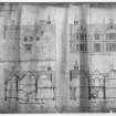
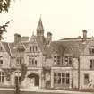
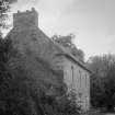
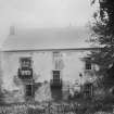
ScotlandsPlaces Home

Scotlands Places

Wauchope House


  • Possible farmhouse, possibly demolished View from W.  Copyright RCAHMS
  • Possible farmhouse, possibly demolished View from S.  Copyright RCAHMS


You may copy, display, store and make derivative works for personal use or use solely within an educational institution by staff and students, under these conditions: the ScotlandsPlaces website is attributed, there is no commercial use or sale, and no public distribution (for example, by hand, email, or web). Full licence details.

Possible farmhouse, possibly demolished View from W. Copyright RCAHMS
Item SC1265665

Organisation

The Royal Commission on the Ancient and Historical Monuments of Scotland

Canmore ID

181181

Site Type

COUNTRY HOUSE

County

ROXBURGHSHIRE

Parish

HOBKIRK

Council

SCOTTISH BORDERS, THE

NGR

NT 5823 0839

Latitude, Longitude

55.367717N, 2.660553W

Images

Architectural Notes
NT50NE 28 5823 0839

Wauchope is shown on the OS Second Edition 1899 Roxburgh Sheet XXXIII.N.E. The house was demolished in 1932.
(Undated) information in NMRS.


Related Material Information - Description of Collections


PA69 (1910)
PHOTOGRAPH ALBUM NO.69: THE EDENHALL ALBUM Album of green cloth with green leather spine and gilt trim. (8 1/2"x7") Insc: (inside back cover) 'Adie and Wedderburn, Edinburgh' Album of amateur snapshots, views from Fife and the Borders and of Fettes College, c.1910. Includes snapshots of family groups taken at Kinaldy House, and Fettes College cricket matches and O.T.C. around 1914-16. There is a view of Edenhall. A faded snap shows the 3/7th Royal Scots officers' tents at Peebles in September 1915, and another is of B Co's officers' hut at the Candle Works, Kinghorn in November 1915. There is a photograph of "Chris in uniform" and one of "Lilias aged 5 weeks, in January 1916". RCAHMS collection General Collection

Photographs

E10531 (9/1876)
West and east elevations. West and east levations. RCAHMS collection Dick Peddie and McKay
E10532 (9/1876)
Sections and elevations. RCAHMS collection Dick Peddie and McKay
C19350
Possible farmhouse, possibly demolished View from W.
C19374
Possible farmhouse, possibly demolished View from S.
RX2524PO (1896)
Copy of historic photograph showing general view. Hawick Museum

Print Room

PA69/5V/2 (1910)
Page 5v/2. General view. PHOTOGRAPH ALBUM NO.69:THE FETTES ALBUM RCAHMS collection General Collection

Prints And Drawings

E10529 (9/1876)
Block and layout plans. RCAHMS collection Dick Peddie and McKay
DPM1870/95/1/10 (9/1876)
Block and layout plans. RCAHMS collection Dick Peddie and McKay
DPM1870/95/1/6 (9/1876)
West and east elevations. West and east levations. RCAHMS collection Dick Peddie and McKay
DPM1870/95/1/7 (9/1876)
Sections and elevations. RCAHMS collection Dick Peddie and McKay
DPM1870/95/2 (4/1877)
Plans and sections of new wine and beer cellars. Plans and elevation. Block plan showing drainage. RCAHMS collection Dick Peddie and McKay
DPM1870/95/1 (9/1876)
Block and layout plans, including sections of ground levels. Plans, sections and elevations. RCAHMS collection Dick Peddie and McKay

Scanned Images

SC1265665
Possible farmhouse, possibly demolished View from W.
SC1265663
Possible farmhouse, possibly demolished View from S.

Related OS 6-inch maps


Related OS 25-inch maps