
Ring Of Brodgar


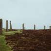
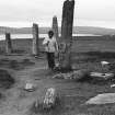
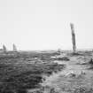
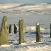
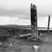
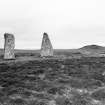
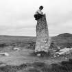
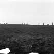
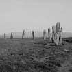
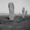
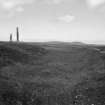
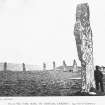
View of stones from within circle.
View in Canmore
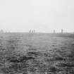
View in Canmore

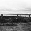
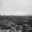
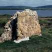
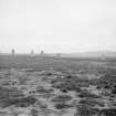
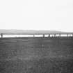
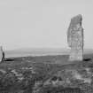
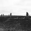
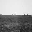
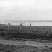
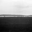
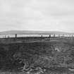
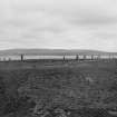
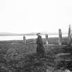
General view from the south east.
View in Canmore
View in Canmore

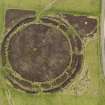
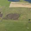
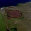
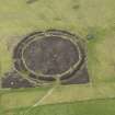
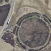
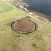
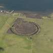
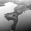
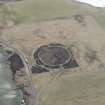
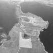
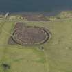
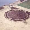
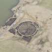
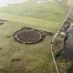
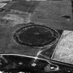
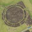
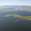
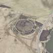
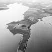
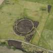
Oblique aerial view centred on the remains of the henge and stone circle at Ring of Brodgar, taken from the SW.
View in Canmore
View in Canmore

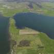
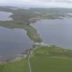
Oblique aerial view with Maes Howe in the foreground looking towards the Loch of Harray with the Ring of Brodgar beyond, taken from the NE.
View in Canmore
View in Canmore

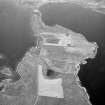
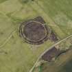
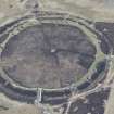
Oblique aerial view centred on the Ring of Brodgar with the cairns adjacent, taken from the NW.
View in Canmore
View in Canmore

General oblique view centred on the Ring of Brodgar with Stenness beyond, taken from the N.
View in Canmore
View in Canmore

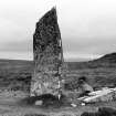
The Ring of Brodgar stone circle.
View in Canmore
View in Canmore

wider view of ring after storm damage.
View in Canmore
View in Canmore

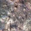
John Hedges and damaged stone.
View in Canmore
View in Canmore

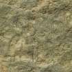
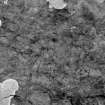
Orkney, Ring of Brodgar, Runic Inscription
View in Canmore
View in Canmore

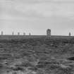
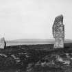
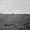
General view from SE.
View in Canmore
View in Canmore

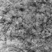
Detail of runes.
View in Canmore
View in Canmore

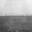
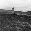
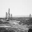
General view from edge of circle.
View in Canmore
View in Canmore

Ring Of Brodgar, HY21SE 1, Ordnance Survey index card, page number 3, Recto
View in Canmore
View in Canmore

Ring Of Brodgar, HY21SE 1, Ordnance Survey index card, Recto
View in Canmore
View in Canmore

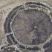
Oblique aerial view of the Ring of Brodgar, henge and stone circle, taken from the W. Also visible are cairns and the 'Comet Stone'
View in Canmore
View in Canmore

Photograph of stone with runes at the Ring of Brodgar.
View in Canmore
View in Canmore

Ring of Brodgar, Orkney, henge.
Copied from original photograph in possession of Richard Welsby.
Digital image only with print made from scanned image.
View in Canmore
View in Canmore

General oblique aerial view centred on the Ring of Bordgar, taken from the NW.
View in Canmore
View in Canmore

Oblique aerial view centred on the Ring of Brodgar, taken from the NW.
View in Canmore
View in Canmore

Oblique aerial view.
View in Canmore
View in Canmore

General view from SE.
View in Canmore
View in Canmore

General oblique aerial view of Ring of Stenness, Ring of Brodgar and Bridge of Brodgar, looking NW.
View in Canmore
View in Canmore

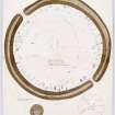
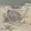
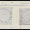
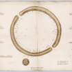
Plan of Ring of Brodgar with notes and measurements, planned by H Dryden and G Petrie in 1851, copied by W Galloway in 1868.
Titled: ''Circle at Stennis, Orkney'.
View in Canmore
View in Canmore

Oblique aerial view.
View in Canmore
View in Canmore

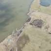
Aerial view of the Ring of Brodgar, henge and stone circle, taken from the SW. Also visible are some of the surrounding cairns.
View in Canmore
View in Canmore

General view.
View in Canmore
View in Canmore

storm damaged stone.
View in Canmore
View in Canmore

Oblique aerial view centred on the Ring of Brodgar stone circle and henge, taken from the ENE.
View in Canmore
View in Canmore

Oblique aerial view with Maes Howe in the foreground looking towards the Loch of Harray with the Ring of Brodgar beyond, taken from the NE.
View in Canmore
View in Canmore

Oblique aerial view centred on the Ring of Brodgar with the cairns adjacent, taken from the SW.
View in Canmore
View in Canmore

Sketch of the Ring of Brodgar, from Sketches of Scottish Antiquities by Waller Hugh Paton (1828-1895)
View in Canmore
View in Canmore

Oblique aerial view.
View in Canmore
View in Canmore

Oblique aerial view.
View in Canmore
View in Canmore

General view.
View in Canmore
View in Canmore

General view from Salt Knowe.
View in Canmore
View in Canmore

The Ring of Brodgar, runic inscription on stone No. 3
View in Canmore
View in Canmore

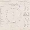
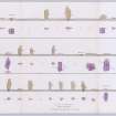
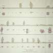
Elevation and plan in three registers of the stones in Ring of Brodgar with measurements and annotations. Planned by H Dryden and G Petrie in 1851 and copied by W Galloway in 1868.
Titled: 'Panorama of the Circle. Stennis. Orkney'.
View in Canmore
View in Canmore

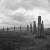
Ring of Brodgar - general view of the monoliths.
View in Canmore
View in Canmore

Oblique aerial view.
View in Canmore
View in Canmore

Oblique aerial view.
View in Canmore
View in Canmore

Oblique aerial view.
View in Canmore
View in Canmore

wider view of circle after storm damage.
View in Canmore
View in Canmore

storm damaged stone.
View in Canmore
View in Canmore

circle after storm damage.
View in Canmore
View in Canmore

John Hedges up a stone.
View in Canmore
View in Canmore

View of stone circle.
View in Canmore
View in Canmore

General view.
View in Canmore
View in Canmore

Ring Of Brodgar, HY21SE 1, Ordnance Survey index card, Recto
View in Canmore
View in Canmore

Ring Of Brodgar, HY21SE 1, Ordnance Survey index card, page number 2, Verso
View in Canmore
View in Canmore

View of stone circle.
View in Canmore
View in Canmore

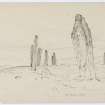
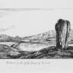
Digital copy of illustration showing two Standing Stones, western Stones of Stenness. The two stones are the Watch Stone (on the left) and the Stone of Odin (on the right) . The Ring of Brodgar is in the background.
Inscribed: ' Western Circle of the Stones of the Stones of Stennis'
View in Canmore
View in Canmore

Oblique aerial view with Maes Howe in the foreground looking towards the Loch of Harray with the Ring of Brodgar beyond, taken from the NE.
View in Canmore
View in Canmore

Oblique aerial view with Maes Howe in the foreground looking towards the Loch of Harray with the Ring of Brodgar beyond, taken from the NE.
View in Canmore
View in Canmore

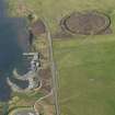
General oblique aerial view of the parking area and the Ring of Brodgar, taken from the NNW.
View in Canmore
View in Canmore

Oblique aerial view centred on the Ring of Brodgar with the cairns adjacent, taken from the SW.
View in Canmore
View in Canmore

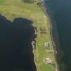
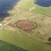
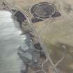
General oblique aerial view centred on the excavations of Brodgar settlement with the Ring of Brodgar beyond, taken from the SSW.
View in Canmore
View in Canmore

View of stone circle.
View in Canmore
View in Canmore

General view.
View in Canmore
View in Canmore

View of Ring of Brodgar stone circle.
View in Canmore
View in Canmore

Ring of Brodgar - general view of the monoliths.
View in Canmore
View in Canmore

Oblique aerial view
View in Canmore
View in Canmore

Oblique aerial view.
View in Canmore
View in Canmore

Oblique aerial view.
View in Canmore
View in Canmore

Oblique aerial view.
View in Canmore
View in Canmore

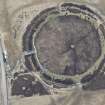
Aerial view of Orkney, Ring of Brodgar, henge and stone circle, taken from the NW. Also visible are cairns and the 'Comet Stone'.
View in Canmore
View in Canmore

Aerial view of Orkney, Ring of Brodgar, henge and stone circle, taken from the SE. Also visible are cairns and the 'Comet Stone'.
View in Canmore
View in Canmore

storm damaged stone.
View in Canmore
View in Canmore

General view from Salt Knowe.
View in Canmore
View in Canmore


Oblique aerial view centred on the Ring of Brodgar.
View in Canmore
View in Canmore

Ring of Brodgar; runes.
View in Canmore
View in Canmore

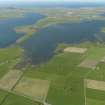
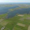
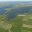
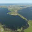
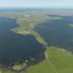
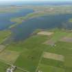
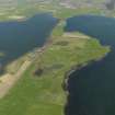
General oblique aerial view centred on the Ring of Brodgar with the Loch of Harray and the Loch of Stenness adjacent, taken from the SE.
View in Canmore
View in Canmore

Oblique aerial view centred on the Ring of Brodgar with the Loch of Harray and the Loch of Stenness adjacent, taken from the SE.
View in Canmore
View in Canmore

Oblique aerial view with Maes Howe in the foreground looking towards the Loch of Harray with the Ring of Brodgar beyond, taken from the NE.
View in Canmore
View in Canmore

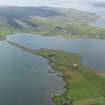
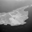
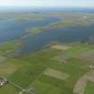
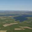
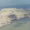
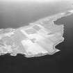
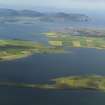
General oblique aerial view of the Loch of Stenness and the Loch of Harray, taken from the NW.
View in Canmore
View in Canmore

Oblique aerial view centred on the Ring of Brodgar, taken from the SE.
View in Canmore
View in Canmore

General oblique view centred on the Ring of Brodgar with Stenness beyond, taken from the N.
View in Canmore
View in Canmore

General view from Salt Knowe.
View in Canmore
View in Canmore

General view from SE.
View in Canmore
View in Canmore

View from West of the Ring of Brodgar, Orkney
View in Canmore
View in Canmore

Oblique aerial view.
View in Canmore
View in Canmore

Ring of Brodgar - general view of the monoliths and ditch.
View in Canmore
View in Canmore

Oblique aerial view.
View in Canmore
View in Canmore

Oblique aerial view.
View in Canmore
View in Canmore

Oblique aerial view.
View in Canmore
View in Canmore

Oblique aerial view.
View in Canmore
View in Canmore

Oblique aerial view.
View in Canmore
View in Canmore

Oblique aerial view.
View in Canmore
View in Canmore

Oblique aerial view.
View in Canmore
View in Canmore

Oblique aerial view.
View in Canmore
View in Canmore

General view.
View in Canmore
View in Canmore

General view from SE.
View in Canmore
View in Canmore

Plan. Photographic copy of a drawing.
View in Canmore
View in Canmore

Oblique aerial view centred on the Ring of Brodgar stone circle and henge, taken from the NNE.
View in Canmore
View in Canmore

General oblique aerial view centred on the Ring of Bordgar, taken from the WNW.
View in Canmore
View in Canmore

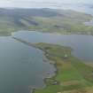
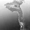
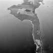
Oblique aerial view across the Loch of Harray with the Ring of Brodgar in the foreground and Hoy beyond, taken from the NE.
View in Canmore
View in Canmore

Oblique aerial view.
View in Canmore
View in Canmore

Photographic copy of Plate VII- The ring of Brodgar.
View in Canmore
View in Canmore

Plans of Ring of Brodgar with notes and measurements; sections through ditch taken at 7 points around circle. Drawn by H Dryden and G Petrie in 1851.
Titled: 'The large circle, Stennis'.
View in Canmore
View in Canmore


You may copy, display, store and make derivative works for personal use or use solely within an educational institution by staff and students, under these conditions: the ScotlandsPlaces website is attributed, there is no commercial use or sale, and no public distribution (for example, by hand, email, or web). Full licence details.
Details
Organisation: Historic Environment Scotland (HES)
Alternative name(s): Ring Of Brogar; Ness Of Brodgar; Circle At Stennis
Canmore ID: 1696
Site type: Henge (neolithic) - (bronze Age), Rune Inscribed Stone (norse), Stone Circle (neolithic) - (bronze Age)
County: Orkney
Parish: Stenness
Council: Orkney Islands