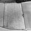
ScotlandsPlaces Home

Scotlands Places

Crailing Tofts


Organisation

The Royal Commission on the Ancient and Historical Monuments of Scotland

Canmore ID

164804

Site Type

SETTLEMENT (POSSIBLE)

County

ROXBURGHSHIRE

Parish

CRAILING

Council

SCOTTISH BORDERS, THE

NGR

NT 7004 2488

Latitude, Longitude

55.516748N, 2.476017W

Images

Archaeological Notes
NT27SW 27 7004 2488.

Information to follow.
RCAHMS (KB) 5 July 2000

Related Material Information - Description of Collections


Photographs

C74471 (25/7/1996)
Crailing Tofts, oblique aerial view, taken from the NNW, centred on the cropmarks of two possible settlements. RCAHMS collection RCAHMS Aerial Photography
C74470 (25/7/1996)
Crailing Tofts, oblique aerial view, taken from the NNE, centred on the cropmarks of two possible settlements. RCAHMS collection RCAHMS Aerial Photography
C74469 (25/7/1996)
Crailing Tofts, oblique aerial view, taken from the ENE, centred on the cropmarks of two possible settlements. RCAHMS collection RCAHMS Aerial Photography
C74468 (25/7/1996)
Crailing Tofts, oblique aerial view, taken from the ESE, centred on the cropmarks of two possible settlements. RCAHMS collection RCAHMS Aerial Photography