
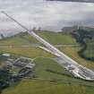
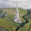
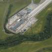
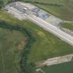
Evanton Airfield


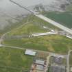
Oblique aerial view of Evanton Airfield and the quay, looking SE.
View in Canmore
View in Canmore

Oblique aerial view of Evanton Airfield and the quay, looking E.
View in Canmore
View in Canmore

Oblique aerial view of Evanton airfield, looking NE.
View in Canmore
View in Canmore

Oblique aerial view of Evanton airfield, looking NNW.
View in Canmore
View in Canmore

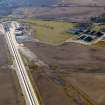
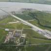
General oblique aerial view looking across the airfield, aircraft hangers, buildings and oil pipeline construction towards the Black Isle, taken from the N.
View in Canmore
View in Canmore

Aerial view of Evanton Airfield, Easter Ross, looking NW.
View in Canmore
View in Canmore

General oblique aerial view looking across the airfield, aircraft hangers, buildings and oil pipeline construction towards the Invergordon and the Cromarty Firth, taken from the WSW.
View in Canmore
View in Canmore

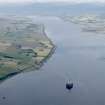
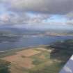
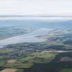
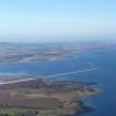
General oblique aerial view of the Cromarty Firth, looking SW.
View in Canmore
View in Canmore

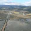
Oblique aerial view of Evanton airfield, looking WSW.
View in Canmore
View in Canmore

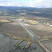
Oblique aerial view of Evanton airfield, looking SSE.
View in Canmore
View in Canmore

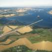
General oblique aerial view centred on the quay with Evanton airfield and the village of Evanton beyond, taken from the E.
View in Canmore
View in Canmore

Aerial view of Cromarty Firth, looking N.
View in Canmore
View in Canmore

General oblique aerial view looking across the airfield, aircraft hangers, buildings and oil pipeline construction towards the Invergordon and the Cromarty Firth, taken from the WSW.
View in Canmore
View in Canmore

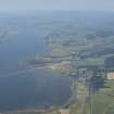
General oblique aerial view of the Cromarty Firth with Alness in the middle distance, looking WSW.
View in Canmore
View in Canmore

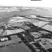
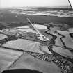
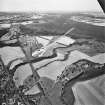
General oblique aerial view of Evanton Village, Evanton Airfield and quay, looking SSW.
View in Canmore
View in Canmore

Oblique aerial view of Evanton Airfield and quay, looking WNW.
View in Canmore
View in Canmore

Oblique aerial view of Evanton airfield, looking SSE.
View in Canmore
View in Canmore

General oblique aerial view looking across the airfield, aircraft hangers, buildings and oil pipeline construction towards the Black Isle, taken from the WNW.
View in Canmore
View in Canmore

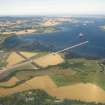
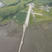
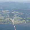
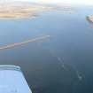
Aerial view of Ard Roy Causeway and Evanton Airfield, Cromarty Firth, looking W.
View in Canmore
View in Canmore

Aerial view of Ard Roy Causeway and Evanton Airfield, Cromarty Firth, looking NW.
View in Canmore
View in Canmore

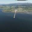
Aerial view of Evanton Airfield and Deephaven Pier, Cromarty Firth, looking NE.
View in Canmore
View in Canmore

Evanton Airfield, NH66NW 34, Ordnance Survey index card, Recto
View in Canmore
View in Canmore

General oblique aerial view looking across the airfield, aircraft hangers, buildings and oil pipeline construction towards the Invergordon and the Cromarty Firth, taken from the WSW.
View in Canmore
View in Canmore

Oblique aerial view of NE part of Cromarty Firth, looking NE.
View in Canmore
View in Canmore
You may copy, display, store and make derivative works for personal use or use solely within an educational institution by staff and students, under these conditions: the ScotlandsPlaces website is attributed, there is no commercial use or sale, and no public distribution (for example, by hand, email, or web). Full licence details.
Details
Organisation: Historic Environment Scotland (HES)
Alternative name(s): Novar Camp
Canmore ID: 13678
Site type: Airfield (20th Century)
County: Ross And Cromarty
Parish: Kiltearn
Council: Highland