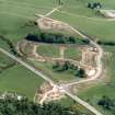
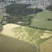
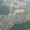
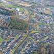
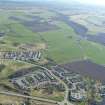
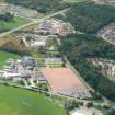
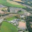
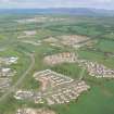
ScotlandsPlaces Home

Scotlands Places

Culduthel


Organisation

The Royal Commission on the Ancient and Historical Monuments of Scotland

Canmore ID

13508

Site Type

RING CAIRN

County

INVERNESS-SHIRE

Parish

INVERNESS AND BONA

Council

HIGHLAND

NGR

NH 6619 4176

Latitude, Longitude

57.446365N, 4.231293W

Images

Archaeological Notes
NH64SE 26 6619 4176.

(NH 66194176) Stone Circle [NR] (Remains of)
OS 6"map, Inverness-shire, 2nd ed., (1906)

Clava-type cairn, Culduthel: 'The cairn has been placed on a small natural rise. It is now at the edge of a patch of thin woodland. It has been so completely robbed that only a few stones of the peristalith remain in situ and a few more stones lie where they have fallen outwards form their original positions. The stones are considerable rounded boulders set on end, four of them contiguous. They vary in height from 1 foot 9 inches to 4 feet, the tallest being in the middle of the existing setting. There can be little doubt that they represent part of the south arc of a cairn kerb though they are not arranged on a true circle. On the OS 6"map of 1871 the site is marked as an almost complete circle lacking only part of the west side'.
A S Henshall 1963, visited 11 April 1957; J Fraser 1884, A Low 1929.

The remains of this cairn are described above.
Visited by OS (J L D) 22 March 1962.

NH 660 417 An evaluation was undertaken in May 2004 prior to housing development. A ring-cairn (NH64SE 26) assumed to be of the Clava type lies immediately NE of the site.
Thirteen trenches (2000m2) were stripped, equivalent to 5% of the development area. Only one archaeological feature was uncovered, at the southern end of the site. This was a pit, circular in plan and filled with a charcoal-rich deposit. It was apparently isolated and no datable finds were recovered from the fill.
Reports lodged with Highland SMR and the NMRS.
Sponsor: Tulloch Homes Ltd.
M Hastie 2004

Related Material Information - Bibliographical References


Fraser, J (1884) 'Descriptive notes on the stone circles of Strathnairn and neighbourhood of Inverness',
Hastie, M (2004) 'Culduthel Mains Farm (Inverness & Bona parish), evaluation',
Henshall, A S (1963) The chambered tombs of Scotland, Edinburgh. Held at RCAHMS: E.7.1.HEN
Low, A (1929) 'A short cist at Culduthel, Inverness',
RCAHMS (1942-3) Emergency Survey 1942-3. Two volumes of typed site descriptions organised by county and parish, with handwritten editorial notes by Angus Graham dated 1960. The majority were written by Graham, some by VG Childe. Occasional references to plans and photographs which are in the manuscript and photographic collections (MS36 and county run respectively). Entries vary from short notes to lengthy multi-descriptions. Held at RCAHMS: A.1.1.SUR
RCAHMS (1979) The Royal Commission on the Ancient and Historical Monuments of Scotland. The archaeological sites and monuments of North-east Inverness, Inverness District, Highland Region, Edinburgh. Held at RCAHMS: A.1.2.ARC(8)

Related Material Information - Description of Collections


Manuscripts

MS5580 (10/2006)
Report on monitoring at Culduthel Phase 6, Inverness. Headland Archaeology Ltd collection Headland Archaeology Ltd