
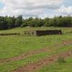
Mugdock Wood, Battery


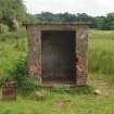
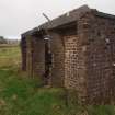
The small telecommunications hut from the WNW
View in Canmore
View in Canmore

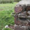
The edifice at the ESE end of the long building platform (NS 54353 77169), which was originally covered with concrete slabs
View in Canmore
View in Canmore

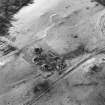
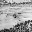
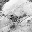
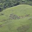
Oblique aerial view centred on the remains of the anti-aircraft battery, taken from the NE.
View in Canmore
View in Canmore

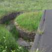
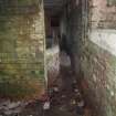
View from the S of the sunken, brick-lined concrete track emerging from the entrance near the NNW corner of the command post
View in Canmore
View in Canmore

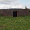
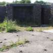
The footings of a cement-skimmed, gable-ended building with a central entrance (NS 54340 77148) on a terrace E of the track
View in Canmore
View in Canmore

An iron loop at the NE corner of the radar block
View in Canmore
View in Canmore

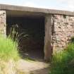
The broad entrance at the NNW corner of the command post from the NW
View in Canmore
View in Canmore

The SSW façade of the radar block with the central entrance
View in Canmore
View in Canmore

Oblique aerial view centred on the remains of the anti-aircraft battery, taken from the SW.
View in Canmore
View in Canmore

Oblique aerial view centred on the remains of the anti-aircraft battery, taken from the SSW.
View in Canmore
View in Canmore

Oblique aerial view centred on the remains of the anti-aircraft battery, taken from the NE.
View in Canmore
View in Canmore

The holdfast in the NNE gun-pit from the ESE with an ammunition locker (behind) and the entrance to the crew shelter (right)
View in Canmore
View in Canmore

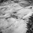
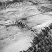
Oblique aerial view of Mugdock Wood anti aircraft battery, looking SW.
View in Canmore
View in Canmore

Oblique aerial view centred on the remains of the anti-aircraft battery, taken from the SW.
View in Canmore
View in Canmore

Oblique aerial view centred on the remains of the anti-aircraft battery, taken from the SSE.
View in Canmore
View in Canmore

The rectangular cistern from the SE
View in Canmore
View in Canmore

The rear of the radar block from the NNE
View in Canmore
View in Canmore

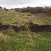
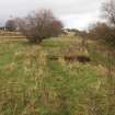
Two heavily grass-grown building platforms (NS 54246 77126, NS 54265 77123) from the W, with the tiers of terraces supporting other buildings rising in the background
View in Canmore
View in Canmore

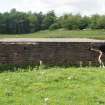
View from the SE of the upstanding brick and concrete structure (NS 54352 77171) bridging a gap between two long Nissen hut platforms
View in Canmore
View in Canmore

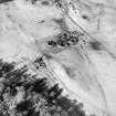
Oblique aerial view centred on the remains of the anti-aircraft battery, taken from the SE.
View in Canmore
View in Canmore

The loops below the flat roof on the ESE side of the radar block
View in Canmore
View in Canmore

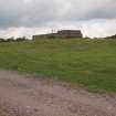
The radar block from the SE
View in Canmore
View in Canmore

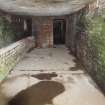
View from the NNE of the plotting room inside the command post, with the later sheep run to the left
View in Canmore
View in Canmore

View from the SSW of the entrance to the sheep run set against the ESE wall of the plotting room
View in Canmore
View in Canmore

You may copy, display, store and make derivative works for personal use or use solely within an educational institution by staff and students, under these conditions: the ScotlandsPlaces website is attributed, there is no commercial use or sale, and no public distribution (for example, by hand, email, or web). Full licence details.
Details
Organisation: Historic Environment Scotland (HES)
Alternative name(s): N14; N9; Clyde Aa Defences; Mugdock Castle
Canmore ID: 105603
Site type: Anti Aircraft Battery (20th Century)
County: Stirlingshire
Parish: Strathblane (stirling)
Council: Stirling