
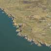
Castle Feather


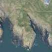
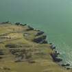
Oblique aerial view.
View in Canmore
View in Canmore

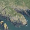
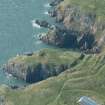
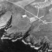
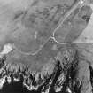
Oblique aerial view centred on the remains of buildings with the remains of the promontory fort adjacent, taken from the NW.
View in Canmore
View in Canmore

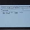
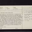
Castle Feather, NX43SW 1, Ordnance Survey index card, Recto
View in Canmore
View in Canmore

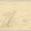
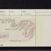
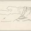
RCAHMS Marginal Land Survey pencil plane table survey drawing,
View in Canmore
View in Canmore

Oblique aerial view.
View in Canmore
View in Canmore

Oblique aerial view.
View in Canmore
View in Canmore

Oblique aerial view.
View in Canmore
View in Canmore

Castle Feather, NX43SW 1, Ordnance Survey index card, page number 2, Verso
View in Canmore
View in Canmore

Castle Feather, NX43SW 1, Ordnance Survey index card, Recto
View in Canmore
View in Canmore

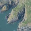
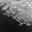
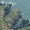
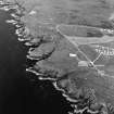
Oblique aerial view centred on the remains of the promontory fort, tower-house, anti-aircraft battery, buildings and huts, taken from the SE.
View in Canmore
View in Canmore

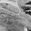
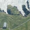
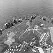
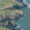
Oblique aerial view centred on the remains of the anti-aircraft battery and buildings with the remains of the promontory fort adjacent, taken from the SE.
View in Canmore
View in Canmore

Oblique aerial view centred on the remains of the anti-aircraft battery and buildings with the remains of the promontory fort adjacent, taken from the NE.
View in Canmore
View in Canmore

Oblique aerial view.
View in Canmore
View in Canmore

Oblique aerial view.
View in Canmore
View in Canmore

Oblique aerial view.
View in Canmore
View in Canmore

Oblique aerial view centred on the remains of the anti-aircraft battery and buildings with the remains of the promontory fort adjacent, taken from the S.
View in Canmore
View in Canmore

Oblique aerial view centred on the remains of the promontory fort, tower-house, anti-aircraft battery, buildings and huts, taken from the NW.
View in Canmore
View in Canmore

Oblique aerial view centred on the remains of the anti-aircraft battery and buildings with the remains of the promontory fort adjacent, taken from the SE.
View in Canmore
View in Canmore

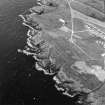
Oblique aerial view centred on the remains of buildings with the remains of the promontory fort adjacent, taken from the SSW.
View in Canmore
View in Canmore

Castle Feather, NX43SW 1, Ordnance Survey index card, page number 1, Recto
View in Canmore
View in Canmore

RCAHMS Marginal Land Survey inked drawing,
View in Canmore
View in Canmore

Oblique aerial view centred on the remains of the anti-aircraft battery and buildings with the remains of the promontory fort adjacent, taken from the ESE.
View in Canmore
View in Canmore

You may copy, display, store and make derivative works for personal use or use solely within an educational institution by staff and students, under these conditions: the ScotlandsPlaces website is attributed, there is no commercial use or sale, and no public distribution (for example, by hand, email, or web). Full licence details.
Details
Organisation: Historic Environment Scotland (HES)
Alternative name(s): Burrow Head
Canmore ID: 63137
Site type: Promontory Fort (period Unassigned), Tower House (medieval)
County: Wigtownshire
Parish: Whithorn
Council: Dumfries And Galloway