
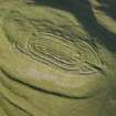
Castle Law, Forgandenny


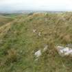
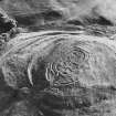
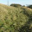
Copy of colour slide showing view of Castle Law,Forgandenny, Tayside, view of fort from east.
NMRS Survey of Private Collection
Digital Image Only
View in Canmore
View in Canmore

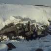
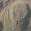
Copy of colour slide showing detail of Castle Law, Forgandenny, Tayside; insc " inner face of inner wall at E end. Note massive stones, looseness of build"
NMRS Survey of Private Collection
Digital Image Only
View in Canmore
View in Canmore

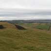
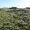
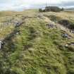
General view from W of the timber-laced walls on the S side of the fort, showing the late 19th century excavation trenches.
View in Canmore
View in Canmore

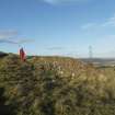
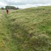
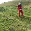
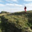
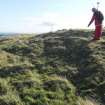
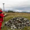
View from S of Mr Ian Parker (RCAHMS) using differential GPS to survey a late 19th century stone dump outside the E end of the timber-laced fort, the result of excavation by Edwin Weston Bell.
View in Canmore
View in Canmore

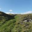
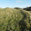
View from E looking along the outer face of the outer timber-laced wall on the S side of the fort.
View in Canmore
View in Canmore

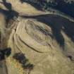
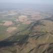
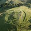
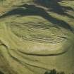
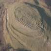
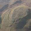
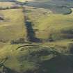
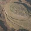
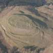
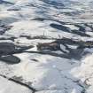
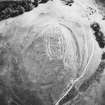
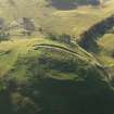
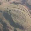
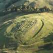
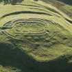
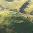
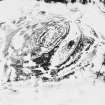
General oblique aerial view of Castle Law fort with Strath Earn and Forgandenny beyond, looking WNW.
View in Canmore
View in Canmore

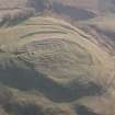
Oblique aerial view of Castle Law fort, looking SSE.
View in Canmore
View in Canmore

Oblique aerial view of Castle Law fort, looking NNE.
View in Canmore
View in Canmore

Oblique aerial view of Castle Law fort, taken from the S.
View in Canmore
View in Canmore

Castle Law, Forgandenny, NO01NE 5, Ordnance Survey index card, page number 1, Recto
View in Canmore
View in Canmore

Castle Law, Forgandenny, NO01NE 5, Ordnance Survey index card, Recto
View in Canmore
View in Canmore

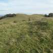
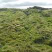
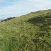
General view looking NW across the terrace on the N side of the fort. The remains of a large circular timber building can be seen in the centre left of the image.
View in Canmore
View in Canmore

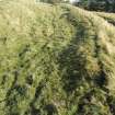
General view looking E of the inner and outer timber-laced walls on the S side of the fort.
View in Canmore
View in Canmore

View from W of Mr Ian Parker (RCAHMS) using differential GPS to survey a late 19th century excavation trench cutting through a circular house platform on the N side of the timber-laced fort.
View in Canmore
View in Canmore

View of Mr Ian Parker (RCAHMS) using differential GPS to survey a late 19th century excavation trench at the W end of the timber-laced fort.
View in Canmore
View in Canmore

View from W of a circular house-platform that overlies the remains of the outer timber-laced wall on the N side of the fort.
View in Canmore
View in Canmore

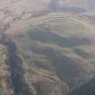
General oblique aerial view of Castle Law fort with Strath Earn beyond, looking E.
View in Canmore
View in Canmore

Oblique aerial view of Castle Law fort, looking SSW.
View in Canmore
View in Canmore

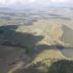
General oblique aerial view of Castle Law, Forgandenny, looking W.
View in Canmore
View in Canmore

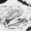
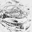
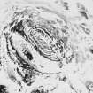
Oblique aerial view.
View in Canmore
View in Canmore

Castle Law, Forgandenny, NO01NE 5, Ordnance Survey index card, Verso
View in Canmore
View in Canmore

Oblique aerial view centred on the remains of Castle Law fort and excavation trenches, taken from the W.
View in Canmore
View in Canmore

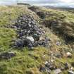
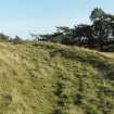
Example of surviving wall-face of one of the timber-laced walls.
View in Canmore
View in Canmore

View from W of a circular house platform on the N side of the timber-laced fort.
View in Canmore
View in Canmore

View from W of a circular house platform on the N side of the timber-laced fort.
View in Canmore
View in Canmore

Oblique aerial view of Castle Law, Forgandenny, fort, taken from the SSW.
View in Canmore
View in Canmore

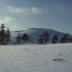
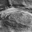
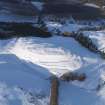
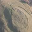
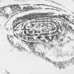
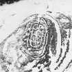
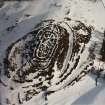
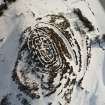
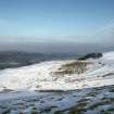
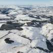
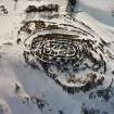
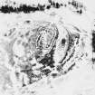
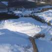
Oblique aerial view of Castle Law fort under snow, looking NNE.
View in Canmore
View in Canmore

Oblique aerial view of Castle Law fort, looking NNW.
View in Canmore
View in Canmore

Oblique aerial view of Castle Law fort, looking WNW.
View in Canmore
View in Canmore

General oblique aerial view of Castle Law fort, looking S.
View in Canmore
View in Canmore

Oblique aerial view of Castle Law fort, looking SSE.
View in Canmore
View in Canmore

Oblique aerial view.
View in Canmore
View in Canmore

Oblique aerial view.
View in Canmore
View in Canmore

Oblique aerial view.
View in Canmore
View in Canmore

Oblique aerial view.
View in Canmore
View in Canmore

Castle Law, Forgandenny, NO01NE 5, Ordnance Survey index card, page number 2, Verso
View in Canmore
View in Canmore

General oblique aerial view centred on the remains of the fort and excavation trenches, taken from the NE.
View in Canmore
View in Canmore

Mr Ian Parker (RCAHMS) using differential GPS to survey a late 19th century excavation trench cutting through a circular house platform on the N side of the timber-laced fort.
View in Canmore
View in Canmore

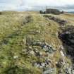
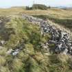
General view from W of the innermost timber-laced wall at the SE corner of the fort.
View in Canmore
View in Canmore

General view from W of the timber-laced walls on the S side of the fort, showing the late 19th century excavation trenches.
View in Canmore
View in Canmore

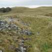
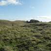
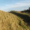
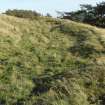
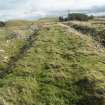
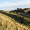
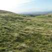
General view from the W of the ramparts and ditches lying immediately S of the timber-laced fort.
View in Canmore
View in Canmore

Oblique aerial view of Castle Law fort, looking N.
View in Canmore
View in Canmore

Oblique aerial view of Castle Law fort, looking N.
View in Canmore
View in Canmore

Oblique aerial view of Castle Law fort, looking WSW.
View in Canmore
View in Canmore

Oblique aerial view of Castle Law fort, looking NW.
View in Canmore
View in Canmore

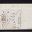
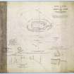
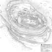
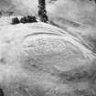
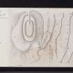
Plan of fort on Castle Law, Forgandenny
View in Canmore
View in Canmore

General oblique aerial view with Castle Law fort in the foreground and Dunning beyond, looking W.
View in Canmore
View in Canmore

Oblique aerial view.
View in Canmore
View in Canmore

Oblique aerial view.
View in Canmore
View in Canmore

Oblique aerial view.
View in Canmore
View in Canmore

Oblique aerial view.
View in Canmore
View in Canmore

Oblique aerial view.
View in Canmore
View in Canmore

Copy of colour slide showing general view of Castle Law, Forgandenny, Tayside, view of fort from SW.
NMRS Survey of Private Collection
Digital Image Only
View in Canmore
View in Canmore

Oblique aerial view centred on the remains of the fort and excavation trenches, with the remains of the framstead adjacent, taken from the NW.
View in Canmore
View in Canmore

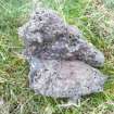
Example of vitrified rock found in the debris below the outermost timber-laced wall on the South side of the fort.
View in Canmore
View in Canmore

General view from W of the timber-laced walls on the S side of the fort, showing the late 19th century excavation trenches.
View in Canmore
View in Canmore

General view from W of the timber-laced walls on the S side of the fort, showing the late 19th century excavation trenches.
View in Canmore
View in Canmore

View from W of Mr Ian Parker (RCAHMS) using differential GPS to survey a circular house platform on the N side of the timber-laced fort.
View in Canmore
View in Canmore

View from W of Mr Ian Parker (RCAHMS) using differential GPS to survey a circular house platform on the N side of the timber-laced fort.
View in Canmore
View in Canmore

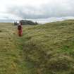
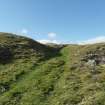
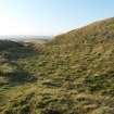
View from W of the row of timber house platforms that are situated between the two sets of ramparts and ditches lying immediately S of the timber-laced fort.
View in Canmore
View in Canmore

View from West of the row of timber house platforms that are situated between the two sets of ramparts and ditches lying immediately S of the timber-laced fort.
View in Canmore
View in Canmore

General view from E of the entrance at the E end of the timber-laced fort.
View in Canmore
View in Canmore

Oblique aerial view of Castle Law, Forgandenny, fort, taken from the SSE.
View in Canmore
View in Canmore

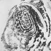
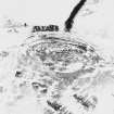
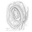
Survey drawing ; fort, Castlelaw, Forgandenny
View in Canmore
View in Canmore

Oblique aerial view of Castle Law fort, looking S.
View in Canmore
View in Canmore

Oblique aerial view of Castle Law fort, looking WSW.
View in Canmore
View in Canmore

General oblique aerial view with Castle Law fort in the foreground and Dunning beyond, looking W.
View in Canmore
View in Canmore

Oblique aerial view.
View in Canmore
View in Canmore

Oblique aerial view.
View in Canmore
View in Canmore

Oblique aerial view.
View in Canmore
View in Canmore

Oblique aerial view.
View in Canmore
View in Canmore

Oblique aerial view.
View in Canmore
View in Canmore

Oblique aerial view centred on the remains of the fort and excavation trenches, taken from the SW.
View in Canmore
View in Canmore

General view from W of the timber-laced walls on the S side of the fort, showing the late 19th century excavation trenches.
View in Canmore
View in Canmore

View from W of one of the circular timber-houses in the enclosure attached to the N side of the timber-laced fort.
View in Canmore
View in Canmore

General view from the W of the ramparts and ditches lying immediately S of the timber-laced fort.
View in Canmore
View in Canmore

View from E of one of the timber house platforms that are situated between the two sets of ramparts and ditches lying immediately S of the timber-laced fort.
View in Canmore
View in Canmore

General view from E of the entrance at the E end of the timber-laced fort.
View in Canmore
View in Canmore

Oblique aerial view of Castle Law, Forgandenny, fort, taken from the NNE.
View in Canmore
View in Canmore

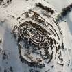
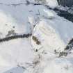
Oblique aerial view of Castle Law fort under snow, looking NE.
View in Canmore
View in Canmore

Oblique aerial view of Castle Law fort, looking NNE.
View in Canmore
View in Canmore

Oblique aerial view of Castle Law fort, looking SSW.
View in Canmore
View in Canmore

Oblique aerial view of Castle Law fort, looking SE.
View in Canmore
View in Canmore

Oblique aerial view of Castle Law fort, looking NW.
View in Canmore
View in Canmore

Oblique aerial view centred on the remains of the fort and excavation trenches, with the remains of the framstead adjacent, taken from the N.
View in Canmore
View in Canmore

View from E of one of the circular timber-houses in the enclosure attached to the N side of the timber-laced fort.
View in Canmore
View in Canmore

View from W of Mr Ian Parker (RCAHMS) using differential GPS to survey a circular house platform on the N side of the timber-laced fort.
View in Canmore
View in Canmore

View from W of Mr Ian Parker (RCAHMS) using differential GPS to survey a circular house platform on the N side of the timber-laced fort.
View in Canmore
View in Canmore

View from W of the row of timber house platforms that are situated between the two sets of ramparts and ditches lying immediately S of the timber-laced fort.
View in Canmore
View in Canmore

View from W of the row of timber house platforms that are situated between the two sets of ramparts and ditches lying immediately S of the timber-laced fort.
View in Canmore
View in Canmore

View from W of the row of timber house platforms that are situated between the two sets of ramparts and ditches lying immediately S of the timber-laced fort.
View in Canmore
View in Canmore

Castlelaw, Forgandenny, Fort, digital publication plan
View in Canmore
View in Canmore

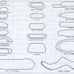
Comparative plans of hillforts with timber-laced walls or ramparts in the NE province from Feachem in Rivet (ed) The Iron Age in N Britain.
View in Canmore
View in Canmore

Oblique aerial view.
View in Canmore
View in Canmore

Oblique aerial view.
View in Canmore
View in Canmore

Oblique aerial view.
View in Canmore
View in Canmore

Castle Law, Forgandenny, NO01NE 5, Ordnance Survey index card, Recto
View in Canmore
View in Canmore

Castle Law, Forgandenny, NO01NE 5, Ordnance Survey index card, Recto
View in Canmore
View in Canmore

Castle Law, Forgandenny, NO01NE 5, Ordnance Survey index card, Recto
View in Canmore
View in Canmore

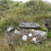
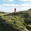
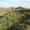
General view of Mr Ian Parker (RCAHMS) using differential GPS to survey a small cairn overlying the inner wall of the timber-laced fort.
View in Canmore
View in Canmore


You may copy, display, store and make derivative works for personal use or use solely within an educational institution by staff and students, under these conditions: the ScotlandsPlaces website is attributed, there is no commercial use or sale, and no public distribution (for example, by hand, email, or web). Full licence details.
Details
Organisation: Historic Environment Scotland (HES)
Alternative name(s): Culteuchar Hill
Canmore ID: 26583
Site type: Bank (earthwork) (period Unassigned), Building (period Unassigned), Fort (period Unassigned), Roundhouse(s) (prehistoric), Vitrified Stone (period Unassigned)
County: Perthshire
Parish: Forgandenny
Council: Perth And Kinross