
St Kilda, Hirta, Village Bay, House Of The Fairies


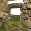
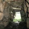
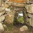
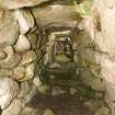
Village Bay, House of the Fairies. The souterrain entrance from within.
View in Canmore
View in Canmore

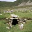
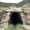
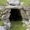
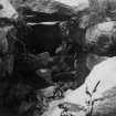
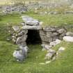
St Kilda, Village Bay. Souterrain entrance.
View in Canmore
View in Canmore

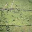
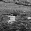
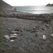
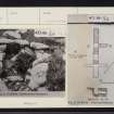
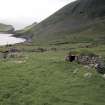
St Kilda, Village Bay. General view of the area of the crofts behind Houses 7-12.
View in Canmore
View in Canmore

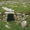
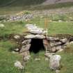
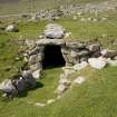
The entrance to the souterrain.
View in Canmore
View in Canmore

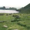
Souterrain, view from NW.
View in Canmore
View in Canmore

View of souterrain from South East.
View in Canmore
View in Canmore

The entrance to the souterrain, St Kilda.
View in Canmore
View in Canmore

St Kilda, Village Bay. Souterrain entrance.
View in Canmore
View in Canmore

The entrance to the souterrain.
View in Canmore
View in Canmore

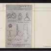
St Kilda. Passage Grave: plan, section, notes.
View in Canmore
View in Canmore

Village Bay, House of the Fairies. View of souterrain from E.
View in Canmore
View in Canmore

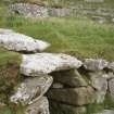
St Kilda, Village Bay. Souterrain entrance.
View in Canmore
View in Canmore

St Kilda, Village Bay. Souterrain. Internal view.
View in Canmore
View in Canmore

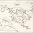
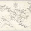
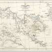
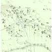
Map of St Kilda or Hirta and adjacent islands and stacs (1963). Annotated with position of antiquities noted on original.
View in Canmore
View in Canmore

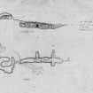
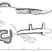
St Kilda Village. Survey drawing of souterrain (Taigh an t-Sithiche) and Cleit 70.
View in Canmore
View in Canmore

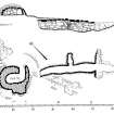
Publication drawing; St Kilda, Souterrain and Cleit 70.
View in Canmore
View in Canmore

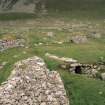
The souterrain on St Kilda looking south-east.
View in Canmore
View in Canmore

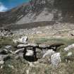
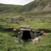
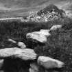
St Kilda, Village Bay. Cleit 70 and souterrain from north.
View in Canmore
View in Canmore

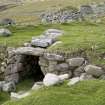
A view of the exterior of the Iron Age souterrain on Hirta, St Kilda, looking over the entrance to cleit 70 beyond. This image was sent to RCAHMS by a Captain Grant c1924.
View in Canmore
View in Canmore

Ordnance Survey Archaeology Division Record Sheet, preparatory map of archaeological sites.
View in Canmore
View in Canmore

Ordnance Survey Archaeology Division Field Sheet. Updated with positions and information of archaeological sites.
View in Canmore
View in Canmore

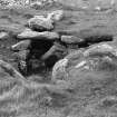
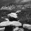
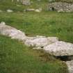
Stone slabs covering the souterrain, St Kilda.
View in Canmore
View in Canmore

Publication Illustration, St Kilda, souterrain and cleit 70. Plan and section. 400dpi copy of GV005690.
View in Canmore
View in Canmore

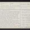
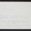
St Kilda, Hirta, Village Bay, House Of The Fairies, NF19NW 7, Ordnance Survey index card, page number 1, Recto
View in Canmore
View in Canmore

St Kilda, Hirta, Village Bay, House Of The Fairies, NF19NW 7, Ordnance Survey index card, Recto
View in Canmore
View in Canmore

St Kilda, Hirta, Village Bay, House Of The Fairies, NF19NW 7, Ordnance Survey index card, Recto
View in Canmore
View in Canmore

St Kilda, Hirta, Village Bay, House Of The Fairies, NF19NW 7, Ordnance Survey index card, page number 1, Recto
View in Canmore
View in Canmore

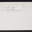
St Kilda, Hirta, Village Bay, House Of The Fairies, NF19NW 7, Ordnance Survey index card, page number 2, Verso
View in Canmore
View in Canmore

Village Bay, House of the Fairies. View from within the souterrain looking towards the entrance.
View in Canmore
View in Canmore

'Entrance to underground dwelling', taken by Cherry Kearton, 1896
View in Canmore
View in Canmore

St Kilda, Village Bay. Souterrain entrance.
View in Canmore
View in Canmore

Village Bay, House of the Fairies. View of souterrain entrance from SE.
View in Canmore
View in Canmore

Village Bay, House of the Fairies. Interior of the souterrain from the entrance.
View in Canmore
View in Canmore

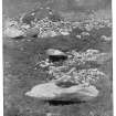
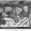
'Antiquities from underground dwelling', taken by Cherry Kearton, 1896
View in Canmore
View in Canmore

A view of the exterior of the Iron Age souterrain on Hirta, St Kilda, looking over the entrance to cleit 70 beyond. This image was sent to RCAHMS by a Captain Grant, 1924.
View in Canmore
View in Canmore

A view into the interior of the Iron Age souterrain on Hirta, St Kilda. This image was sent to RCAHMS by a Captain Grant, 1924.
View in Canmore
View in Canmore

Village Bay, House of the Fairies. View of souterrain from SE.
View in Canmore
View in Canmore

Village Bay, House of the Fairies. View of souterrain from SE.
View in Canmore
View in Canmore

St Kilda, Village Bay. Cleit 70 and souterrain from north east
View in Canmore
View in Canmore

St Kilda, Village Bay. Souterrain, from south.
View in Canmore
View in Canmore

Publication Illustration, St Kilda, Tobar Childa field system. 400dpi copy of GV005719.
View in Canmore
View in Canmore

St Kilda, Hirta, Village Bay, House Of The Fairies, NF19NW 7, Ordnance Survey index card, page number 2, Verso
View in Canmore
View in Canmore
You may copy, display, store and make derivative works for personal use or use solely within an educational institution by staff and students, under these conditions: the ScotlandsPlaces website is attributed, there is no commercial use or sale, and no public distribution (for example, by hand, email, or web). Full licence details.
Details
Organisation: Historic Environment Scotland (HES)
Alternative name(s): Taigh An T-sithiche
Canmore ID: 9697
Site type: Souterrain (prehistoric), Spearhead (iron)(viking)
County: Inverness-shire
Parish: Harris
Council: Western Isles