
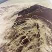
Rubers Law


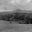
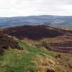
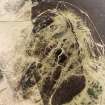
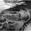
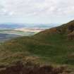
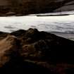
General view.
View in Canmore
View in Canmore

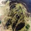
General view from the E
View in Canmore
View in Canmore

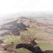
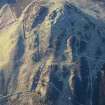
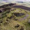
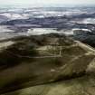
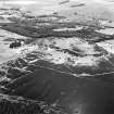
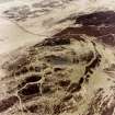
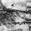
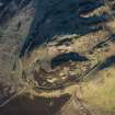
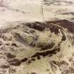
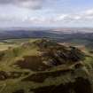
Rubers Law, oblique aerial view, taken from the NE, showing Rubers Law fort and roman signal station in the background of the photograph.
View in Canmore
View in Canmore

Rubers Law, oblique aerial view, taken from the NE, showing Rubers Law fort and roman signal station in the background of the photograph.
View in Canmore
View in Canmore

Rubers Law, oblique aerial view, taken from the NE, showing fort and roman signal station.
View in Canmore
View in Canmore

Rubers Law, oblique aerial view, taken from the NE, showing fort and roman signal station.
View in Canmore
View in Canmore

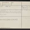
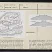
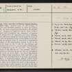
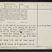
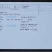
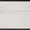
Rubers Law, NT51NE 8, Ordnance Survey index card, page number 4, Verso
View in Canmore
View in Canmore

Rubers Law, NT51NE 8, Ordnance Survey index card, page number 2, Verso
View in Canmore
View in Canmore

Rubers Law, NT51NE 8, Ordnance Survey index card, page number 6, Verso
View in Canmore
View in Canmore

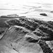
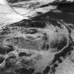
Oblique aerial view.
View in Canmore
View in Canmore

Oblique aerial view.
View in Canmore
View in Canmore

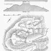
Publication drawing; plan and section of Rubers Law fort.
View in Canmore
View in Canmore

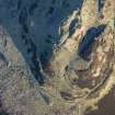
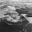
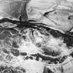
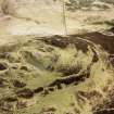
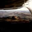
Oblique aerial view centred on the summit area, facing SW
View in Canmore
View in Canmore

Oblique aerial view facing N
View in Canmore
View in Canmore

Oblique aerial view.
View in Canmore
View in Canmore

Oblique aerial view.
View in Canmore
View in Canmore

Oblique aerial view.
View in Canmore
View in Canmore

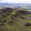
Oblique aerial view of the fort on Rubers Law, looking SW.
View in Canmore
View in Canmore

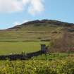
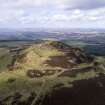
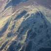
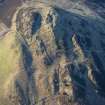
Rubers Law from NE, showing position of fort.
View in Canmore
View in Canmore

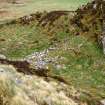
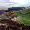
View of the rampart delimiting the E side of the annexe from the S side of the summit
View in Canmore
View in Canmore

Oblique aerial view of the annexe immediately SW of the summit, facing NE. The entrance to the annexe is in the foreground.
View in Canmore
View in Canmore

Oblique aerial view facing NNW
View in Canmore
View in Canmore

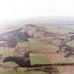
Aerial view of Rubers Law fort and roman signal station, taken from the WSW.
View in Canmore
View in Canmore

Aerial view of Rubers Law fort and roman signal station, taken from the SW.
View in Canmore
View in Canmore

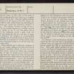
Rubers Law, NT51NE 8, Ordnance Survey index card, page number 3, Recto
View in Canmore
View in Canmore

Oblique aerial view.
View in Canmore
View in Canmore

Oblique aerial view of the fort on Rubers Law, looking SSW.
View in Canmore
View in Canmore

Oblique aerial view.
View in Canmore
View in Canmore

View of the outermost rampart at the SW
View in Canmore
View in Canmore

Rubers Law, oblique aerial view, taken from the NW, showing fort and roman signal station.
View in Canmore
View in Canmore

Aerial view of Rubers Law fort and roman signal station, taken from the E.
View in Canmore
View in Canmore

Oblique aerial view.
View in Canmore
View in Canmore

Oblique aerial view.
View in Canmore
View in Canmore

Oblique aerial view of the fort on Rubers Law, looking S.
View in Canmore
View in Canmore

Oblique aerial view of the fort on Rubers Law, looking SSE.
View in Canmore
View in Canmore

Oblique aerial view.
View in Canmore
View in Canmore

Oblique aerial view.
View in Canmore
View in Canmore

Rubers Law, oblique aerial view, taken from the NW, showing fort and roman signal station.
View in Canmore
View in Canmore

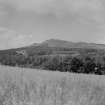
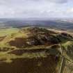
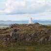
View of summit and triangulation pillar, with the Eildon Hills in the background.
View in Canmore
View in Canmore

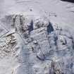
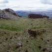
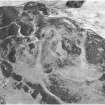
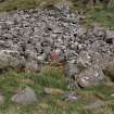
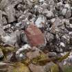
A possibly Roman block of sandstone in the screes on the SW side of the gully N of the summit
View in Canmore
View in Canmore

Rubers Law, oblique aerial view, taken from the NE, showing fort and roman signal station.
View in Canmore
View in Canmore

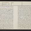
Rubers Law, NT51NE 8, Ordnance Survey index card, page number 1, Recto
View in Canmore
View in Canmore

Rubers Law, NT51NE 8, Ordnance Survey index card, page number 5, Recto
View in Canmore
View in Canmore

Rubers Law, NT51NE 8, Ordnance Survey index card, Recto
View in Canmore
View in Canmore

Oblique aerial view.
View in Canmore
View in Canmore

Oblique aerial view.
View in Canmore
View in Canmore

Oblique aerial view of the fort on Rubers Law, looking S.
View in Canmore
View in Canmore

Oblique aerial view of the fort on Rubers Law, looking ESE.
View in Canmore
View in Canmore

View of entrance
View in Canmore
View in Canmore

Rubers Law, oblique aerial view, taken from the NW, showing fort and roman signal station.
View in Canmore
View in Canmore

Oblique aerial view.
View in Canmore
View in Canmore

Oblique aerial view.
View in Canmore
View in Canmore

Rubers Law, NT51NE 8, Ordnance Survey index card, Recto
View in Canmore
View in Canmore

Oblique aerial view.
View in Canmore
View in Canmore

Oblique aerial view.
View in Canmore
View in Canmore

Rubers Law, oblique aerial view, taken from the NE, showing Rubers Law fort and roman signal station in the background of the photograph.
View in Canmore
View in Canmore

The rampart of the annexe N of the entrance on the W
View in Canmore
View in Canmore

Close-up of a possibly Roman block of sandstone in the screes on the S side of the gully NW of the summit
View in Canmore
View in Canmore

Oblique aerial view centred on the summit area, facing SW
View in Canmore
View in Canmore

Oblique aerial view facing N
View in Canmore
View in Canmore

Oblique aerial view.
View in Canmore
View in Canmore

Rubers Law, NT51NE 8, Ordnance Survey index card, Recto
View in Canmore
View in Canmore
You may copy, display, store and make derivative works for personal use or use solely within an educational institution by staff and students, under these conditions: the ScotlandsPlaces website is attributed, there is no commercial use or sale, and no public distribution (for example, by hand, email, or web). Full licence details.
Details
Organisation: Historic Environment Scotland (HES)
Alternative name(s): Ruberslaw
Canmore ID: 55249
Site type: Fort(s) (prehistoric), Signal Station (roman)
County: Roxburghshire
Parish: Cavers
Council: Scottish Borders, The