
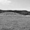
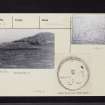
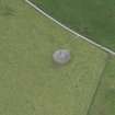
Nether Largie North


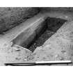
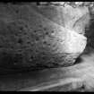
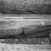
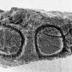
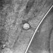
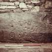
View of capstone from cist.
View in Canmore
View in Canmore

Oblique aerial view centred on the church, churchyard, burial-ground and museum with the remains of the cairns adjacent, taken from the NE.
View in Canmore
View in Canmore

Oblique aerial view centred on the church, churchyard, burial-ground and museum with the remains of the cairns adjacent, taken from the N.
View in Canmore
View in Canmore

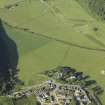
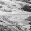
General oblique aerial view centred on the gravel quarry and the site of the excavation of the pit-defined enclosure with the church, churchyard, burial-ground, museum and remains of the cairns adjacent, taken from the NNE.
View in Canmore
View in Canmore

Oblique aerial view.
View in Canmore
View in Canmore

RCAHMS
View in Canmore
View in Canmore

RCAHMS
View in Canmore
View in Canmore

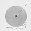
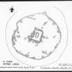
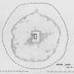
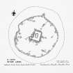
Plan of cairn ink 1:100 RCAHMS
View in Canmore
View in Canmore

GUA/136,135,137 S. Driscoll
View in Canmore
View in Canmore


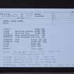
Nether Largie North, NR89NW 4, Ordnance Survey index card, Recto
View in Canmore
View in Canmore

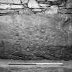
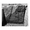
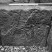
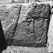
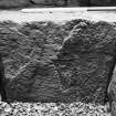
Decorated Slab RCAHMS
View in Canmore
View in Canmore

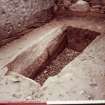
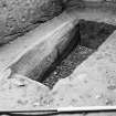
Cist from NW
View in Canmore
View in Canmore

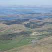
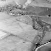
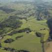
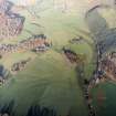
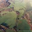
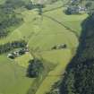
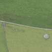
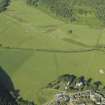
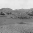
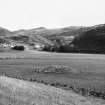
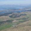
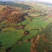
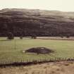
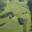
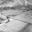
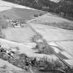
General oblique aerial view of the Kilmartin valley centred on the remains of the chambered cairn, standing stones, stone setting and cairns and the farmstead and school, taken from the SSW.
View in Canmore
View in Canmore

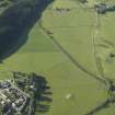
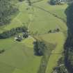
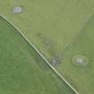
Oblique aerial view centred on the farmstead and school, with the remains of the cairns adjacent, taken from the SSW.
View in Canmore
View in Canmore

RCAHMS
View in Canmore
View in Canmore

Photograph of drawing of flat axes
View in Canmore
View in Canmore

RCAHMS
View in Canmore
View in Canmore

Nether Largie North, NR89NW 4, Ordnance Survey index card, Recto
View in Canmore
View in Canmore

Ministry of Works plan.
View in Canmore
View in Canmore

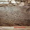
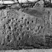
Detail of decorated capstone.
View in Canmore
View in Canmore

Oblique aerial view.
View in Canmore
View in Canmore

Oblique aerial view.
View in Canmore
View in Canmore

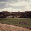
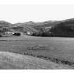
General oblique view of the valley showing the remains of the standing stones and cairns, and the school and farmstead, taken from the SW.
View in Canmore
View in Canmore

General oblique view of the valley showing the remains of the standing stones and cairns, and the school and farmstead, taken from the SSW.
View in Canmore
View in Canmore

RCAHMS
View in Canmore
View in Canmore

GUA/148 S. Driscoll
View in Canmore
View in Canmore

RCAHMS
View in Canmore
View in Canmore

RCAHMS
View in Canmore
View in Canmore

Nether Largie North, NR89NW 4, Ordnance Survey index card, page number 1, Recto
View in Canmore
View in Canmore

View from SW
View in Canmore
View in Canmore

General oblique aerial view of the Kilmartin valley centred on the remains of the chambered cairn, standing stones, stone setting and cairns and the farmstead and school, taken from the S.
View in Canmore
View in Canmore

Oblique aerial view.
View in Canmore
View in Canmore

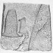
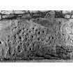
Underside of capstone
View in Canmore
View in Canmore

Decorated Slab RCAHMS
View in Canmore
View in Canmore

RCAHMS
View in Canmore
View in Canmore

Plan Survey SDD
View in Canmore
View in Canmore

Nether Largie North, NR89NW 4, Ordnance Survey index card, page number 2, Recto
View in Canmore
View in Canmore

Oblique aerial view centred on the church, churchyard, burial-ground and museum with the remains of the cairns adjacent, taken from the NE.
View in Canmore
View in Canmore

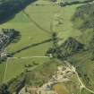
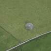
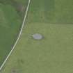
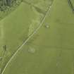
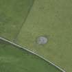
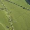
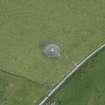
Oblique aerial view centred on the remains of the cairns, taken from the SSE.
View in Canmore
View in Canmore

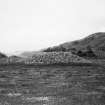
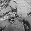
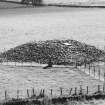
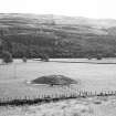
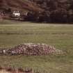
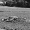
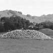
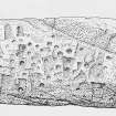
General view of cairn
View in Canmore
View in Canmore

Oblique aerial view.
View in Canmore
View in Canmore

Oblique aerial view.
View in Canmore
View in Canmore

RCAHMS
View in Canmore
View in Canmore

View from SW
View in Canmore
View in Canmore

RCAHMS
View in Canmore
View in Canmore

Plan Survey SDD
View in Canmore
View in Canmore

Nether Largie North, NR89NW 4, Ordnance Survey index card, Recto
View in Canmore
View in Canmore

Underside of capstone
View in Canmore
View in Canmore

Oblique aerial view centred on the remains of the cairns, taken from the SW.
View in Canmore
View in Canmore

General oblique aerial view of the Kilmartin valley centred on the remains of the chambered cairn, standing stones, stone setting and cairns and the farmstead and school, taken from the S.
View in Canmore
View in Canmore

Oblique aerial view.
View in Canmore
View in Canmore

RCAHMS
View in Canmore
View in Canmore

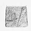
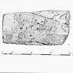
Drawing of cist slab ink 1:10 RCAHMS
View in Canmore
View in Canmore

Plan, Decorated End Slab SDD
View in Canmore
View in Canmore

Cist from NW
View in Canmore
View in Canmore

Nether Largie North, NR89NW 4, Ordnance Survey index card, Recto
View in Canmore
View in Canmore

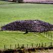
View of cairn from the north-west.
View in Canmore
View in Canmore

General oblique view of the valley showing the remains of the standing stones and cairns at Kilmartin, and the school and farmstead, taken from the SE.
View in Canmore
View in Canmore

Oblique aerial view.
View in Canmore
View in Canmore

Oblique aerial view.
View in Canmore
View in Canmore

Oblique aerial view.
View in Canmore
View in Canmore

RCAHMS
View in Canmore
View in Canmore

Plan, Decorated Side Slab SDD
View in Canmore
View in Canmore

Nether Largie North, NR89NW 4, Ordnance Survey index card, page number 2, Verso
View in Canmore
View in Canmore

Nether Largie North, NR89NW 4, Ordnance Survey index card, Recto
View in Canmore
View in Canmore

Nether Largie North, NR89NW 4, Ordnance Survey index card, Recto
View in Canmore
View in Canmore

Nether Largie North, NR89NW 4, Ordnance Survey index card, Recto
View in Canmore
View in Canmore

General oblique aerial view of the Kilmartin valley centred on the remains of the chambered cairn, standing stones, stone setting and cairns and the farmstead and school, taken from the S.
View in Canmore
View in Canmore

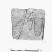
Drawing of cup and ring marked stone.
View in Canmore
View in Canmore

Oblique aerial view.
View in Canmore
View in Canmore

GUA/136,135,137 S. Driscoll
View in Canmore
View in Canmore

RCAHMS
View in Canmore
View in Canmore

RCAHMS
View in Canmore
View in Canmore

Drawing of cist cover ink 1:10 RCAHMS
View in Canmore
View in Canmore

GUA/136,135,137 S. Driscoll
View in Canmore
View in Canmore

View of capstone from cist.
View in Canmore
View in Canmore


You may copy, display, store and make derivative works for personal use or use solely within an educational institution by staff and students, under these conditions: the ScotlandsPlaces website is attributed, there is no commercial use or sale, and no public distribution (for example, by hand, email, or web). Full licence details.
Details
Organisation: Historic Environment Scotland (HES)
Alternative name(s):
Canmore ID: 39482
Site type: Cairn (bronze Age)
County: Argyll
Parish: Kilmartin
Council: Argyll And Bute