
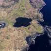
Skye, Rubh' An Dunain


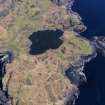
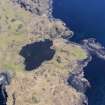
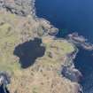
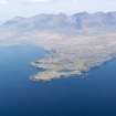
Oblique aerial view centred on Loch na h-Airde, the 'Viking Canal’ and Rubh' an Dunain, taken from the SW.
View in Canmore
View in Canmore

Oblique aerial view centred on Loch na h-Airde, the 'Viking Canal’ and Rubh' an Dunain, taken from the SE.
View in Canmore
View in Canmore

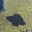
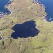
Oblique aerial view centred on Loch na h-Airde, the 'Viking Canal’ and Rubh' an Dunain, taken from the ENE.
View in Canmore
View in Canmore

Oblique aerial view centred on Loch na h-Airde, the 'Viking Canal’ and Rubh' an Dunain, taken from the NE.
View in Canmore
View in Canmore

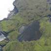
Oblique aerial view centred on Loch na h-Airde, the 'Viking Canal’ and the remains of the dun at Rubh' an Dunain, taken from the SW.
View in Canmore
View in Canmore

Oblique aerial view centred on Loch na h-Airde, the 'Viking Canal’ and Rubh' an Dunain, taken from the WSW.
View in Canmore
View in Canmore

Oblique aerial view centred on Loch na h-Airde, the 'Viking Canal’ and Rubh' an Dunain, taken from the WSW.
View in Canmore
View in Canmore

Skye, Rubh' An Dunain, NG31NE 3, Ordnance Survey index card, Recto
View in Canmore
View in Canmore

Oblique aerial view centred on Loch na h-Airde, the 'Viking Canal’ and the remains of the dun at Rubh' an Dunain, taken from the SSW.
View in Canmore
View in Canmore

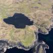
Oblique aerial view centred on Loch na h-Airde, the 'Viking Canal’ and Rubh' an Dunain, taken from the W.
View in Canmore
View in Canmore

Oblique aerial view centred on Loch na h-Airde, the 'Viking Canal’ and Rubh' an Dunain, taken from the SE.
View in Canmore
View in Canmore

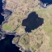
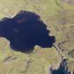
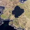
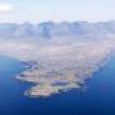
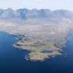
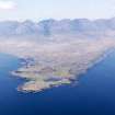
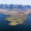
General oblique aerial view centred on Loch na h-Airde, the 'Viking Canal’ and Rubh' an Dunain with the Cuillin Hills in the background, taken from the WSW.
View in Canmore
View in Canmore

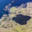
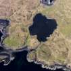
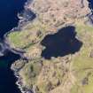
Oblique aerial view centred on the harbour at Loch na h-Airde, the 'Viking Canal’ and Rubh' an Dunain, taken from the S.
View in Canmore
View in Canmore

Oblique aerial view centred on Loch na h-Airde, the 'Viking Canal’ and Rubh' an Dunain, taken from the SSW.
View in Canmore
View in Canmore

Oblique aerial view centred on Loch na h-Airde, the 'Viking Canal’ and Rubh' an Dunain, taken from the SSE.
View in Canmore
View in Canmore

Oblique aerial view centred on Loch na h-Airde, the 'Viking Canal’ and Rubh' an Dunain, taken from the SW.
View in Canmore
View in Canmore

General oblique aerial view centred on Loch na h-Airde, the 'Viking Canal’ and Rubh' an Dunain with the Cuillin Hills in the background, taken from the WSW.
View in Canmore
View in Canmore

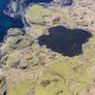
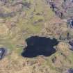
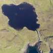
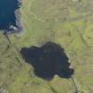
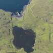
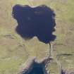
Oblique aerial view centred on Loch na h-Airde, taken from the SSE.
View in Canmore
View in Canmore

Oblique aerial view centred on Loch na h-Airde, the 'Viking Canal’ and Rubh' an Dunain, taken from the WNW.
View in Canmore
View in Canmore

General oblique aerial view centred on Loch na h-Airde, the 'Viking Canal’ and Rubh' an Dunain with the Cuillin Hills in the background, taken from the WSW.
View in Canmore
View in Canmore

General oblique aerial view centred on Loch na h-Airde, the 'Viking Canal’ and Rubh' an Dunain with the Cuillin Hills in the background, taken from the WSW.
View in Canmore
View in Canmore

General oblique aerial view centred on Loch na h-Airde, the 'Viking Canal’ and Rubh' an Dunain with the Cuillin Hills in the background, taken from the SW.
View in Canmore
View in Canmore

Skye, Rubh' An Dunain, NG31NE 3, Ordnance Survey index card, Recto
View in Canmore
View in Canmore

Oblique aerial view centred on Loch na h-Airde, the 'Viking Canal’ and the remains of the dun at Rubh' an Dunain, taken from the E.
View in Canmore
View in Canmore

Oblique aerial view centred on Loch na h-Airde, the 'Viking Canal’ and the remains of the dun at Rubh' an Dunain, taken from the S.
View in Canmore
View in Canmore

Oblique aerial view centred on Loch na h-Airde, the 'Viking Canal’ and Rubh' an Dunain, taken from the E.
View in Canmore
View in Canmore

General oblique aerial view centred on Loch na h-Airde, the 'Viking Canal’ and Rubh' an Dunain with the Cuillin Hills in the background, taken from the SW.
View in Canmore
View in Canmore

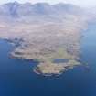
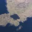
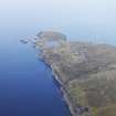
Oblique aerial view of the remains of the township, harbour and cultivation remains at Rubh' an Dunain, Isle of Skye, taken from the S.
View in Canmore
View in Canmore

General oblique aerial view centred on Loch na h-Airde, the 'Viking Canal’ and the remains of the dun at Rubh' an Dunain, taken from the WNW.
View in Canmore
View in Canmore

General oblique aerial view centred on the harbour at Loch na h-Airde, the 'Viking Canal’ and Rubh' an Dunain, looking WSW.
View in Canmore
View in Canmore

General oblique aerial view centred on Loch na h-Airde, the 'Viking Canal’ and Rubh' an Dunain with the Cuillin Hills in the background, taken from the WSW.
View in Canmore
View in Canmore
You may copy, display, store and make derivative works for personal use or use solely within an educational institution by staff and students, under these conditions: the ScotlandsPlaces website is attributed, there is no commercial use or sale, and no public distribution (for example, by hand, email, or web). Full licence details.
Details
Organisation: Historic Environment Scotland (HES)
Alternative name(s): Rudh' An Dunain
Canmore ID: 11023
Site type: Township (period Unassigned)
County: Inverness-shire
Parish: Bracadale
Council: Highland